
Oslov
| Oslov | |||||
|---|---|---|---|---|---|
|
|||||
| Basic data | |||||
| State : |
|
||||
| Region : | Jihočeský kraj | ||||
| District : | Písek | ||||
| Area : | 1937 ha | ||||
| Geographic location : | 49 ° 24 ' N , 14 ° 13' E | ||||
| Height: | 421 m nm | ||||
| Residents : | 337 (Jan. 1, 2019) | ||||
| Postal code : | 398 18 | ||||
| License plate : | C. | ||||
| traffic | |||||
| Street: | Záhoří - Zvíkovské Podhradí | ||||
| Next international airport : | České Budějovice Airport | ||||
| structure | |||||
| Status: | local community | ||||
| Districts: | 3 | ||||
| administration | |||||
| Mayor : | František Hašek (as of 2013) | ||||
| Address: | Oslov 86 398 35 Oslov |
||||
| Municipality number: | 549703 | ||||
| Website : | www.oslov.cz | ||||


Oslov (German Woslau , formerly Woslow ) is a municipality in the Czech Republic . It is located twelve kilometers northeast of Písek and belongs to the Okres Písek .
geography
Oslov is located in the Central Bohemian hill country on a plateau between the valleys of the Vltava and Otava, which are flooded with the Orlík reservoir . To the northwest of the village the Lomnice flows into the Otava, east of the Hrejkovický potok into the Vltava. The Trušovský potok and Strouha brooks have their source in Oslov. State road II / 138 runs through Oslov between Zvíkovské Podhradí and Záhoří . The Otava rises to the south (453 m).
Neighboring towns are Strouha, Dejmov, zvíkovské podhradí , U Moravců and U Kloboučníků in the north, V Dolanech, Kučeř , Květov and Vusi in the Northeast, Zběrov, Červená 2. díl , Branice and Stehlovice the east, Jetětice , Jetětické Samoty, Habr, Truhlařov, Červená , Pazderna, Babák and Struhy in the south-east, Červený Újezdec and Vlastec in the south, Tukleky, Rybárna, Pazderny, Louka and Jistec in the south-west, Doupata, Dědovice and U Chyšáků, in the west, and Dolní Ostrovec, Horní Ostrovec Svatá Anna in the northwest.
history
The village was first mentioned in documents in 1226, when King Přemysl Otakar I acquired the Oslawer Sprengel in exchange for six other villages from the Doksany monastery . Shortly afterwards he had the royal castle Klingenberg built on the rocky spur at the confluence of the Vltava and Otava rivers . There is evidence of a pastor in Oslaw since 1384 . After the Hussites besieged Klingenberg Castle in 1430 , King Sigismund pledged the Klingenberg rule to Ulrich II von Rosenberg in 1431 , because he feared that his burgrave Kunata Kapléř would soon overflow to the rebels. Heinrich V von Rosenberg , who had taken over the indebted rule in 1472, sold a quarter of the properties of the House of Rosenberg on September 28, 1473 , including the Klingenberger Pfand, to his cousin Bohuslav V von Schwanberg . In 1574, Christoph von Schwanberg combined the Klingenberg estate with the Worlik estate he had acquired three years earlier and bought Klingenberg the following year as hereditary property. After the battle of the White Mountain , the estate of Peter von Schwanberg was confiscated and in 1622 the Eggenberg owners of the Worlik and Klingenberg estate. During the Thirty Years' War the parish in Oslaw went out and the church was assigned to the parish of Zahoř as a branch. After the male line of Eggenberg died out in 1717, the Schwarzenberg family inherited their property. In 1787 the church got its own localist.
In 1837 Woslow , also called Wozlow or Woslaw , consisted of 36 houses with 406 inhabitants, including two Israelite families . Under the patronage of the religious fund, the local church of St. Leonardus, the localist house and the school. There was also a farm and a sheep farm. The one-layer Zbirow ( Zběrov ), consisting of three cottagers, was on the side . Woslow was the parish for Podhrad , Roth-Augezd , St. Anna , Lauka ( Louka ), Tuklek ( Tukleky ) and Stiedronin ( Štědronín ). Until the middle of the 19th century, Woslow remained subject to the Fideikommissherrschaft Worlik, including the allodial goods Zalužan, Zbenitz and Bukowan, as part of the rule of Klingenberg.
After the abolition of patrimonial formed oslav / Woslow 1850 a district of the municipality Podhradí in the district administration and the judicial district Písek Mirovice. The village has been called Oslov since 1880. Oslov and Svatá Anna broke away from Zvíkovské Podhradí in 1928 and formed their own community. During the German occupation , Oslov was a center of partisan resistance. In the summer of 1943 the group was discovered by the Gestapo and 21 residents were executed.
Between 1956 and 1963 the Orlík dam was built with which the Vltava valley Červená 1. díl and Červená 3. díl and the Otava valley Cukava, Mošovice, U Urycha and U Vlků were flooded. With the rise of the water level by 35 m, the famous Otava rapids in the area of the Lomnice estuary also disappeared; Some parts of the former Sedláček path are still visible.
In 1964 Tukleky and on January 1, 1980 Zvíkovské Podhradí Oslov were incorporated. On November 24, 1990, Zvíkovské Podhradí broke away from Oslov and formed its own community.
Community structure
The municipality Oslov consists of the districts Oslov ( Woslau ), Svatá Anna ( St. Anna ) and Tukleky ( Tuklek ) and the layers Dejmov, Pazderny, Strouha, U Chyšáků and Zběrov ( Zbirow ).
The earlier settlements of Červená 3. díl, Cukava ( Zukawi ), U Urycha and U Vlků were flooded.
Attractions
.jpg)
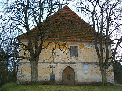
- Filial church of Leonhard, the Gothic building was built in the 14th century and was converted to Baroque style in the 18th century. In the church there is the tomb of a Fraulein von Schwanberg († 1604).
- Wayside shrine at the northern exit of Oslov, it dates from the 17th century and was moved a few meters to the west in 1996
- Memorial stone for the victims of the Second World War, in front of the cemetery, created in 1947
- Memorial to those who died in World War I, opposite the church
- Chapel of St. Anna in Svatá Anna, built 1545–1548
- Center of Tukleky, it was declared a village monument protection zone because of its ensemble of homesteads in folk building style
- Chapel of St. Trinity in Tukleky, built in the second half of the 19th century
- Výří Skály nature reserve , rocky slope at the bend of the Otava, southwest of Oslov. The nature reserve Dědovické stráně is located on the opposite sliding slope
- Krkavčina nature reserve , rocky slope at the bend of the Otava, west of Oslov
- Railway bridge over the Vltava near Červená, the 253 m long structure on two stone pillars 68 m high was built between 1886 and 1889. It was the first railway bridge in Bohemia that was erected in a flying assembly without scaffolding.

Church of St. Leonhard in Oslov
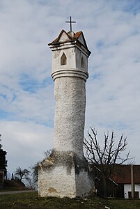
Wayside shrine in Oslov
Chapel of St. Anna in Svatá Anna

.jpg)

Sons and daughters of the church
- Martin Josef Říha (1839–1907), Bishop of Budweis
Web links
Individual evidence
- ↑ Český statistický úřad - The population of the Czech municipalities as of January 1, 2019 (PDF; 0.8 MiB)
- ^ Johann Gottfried Sommer : The Kingdom of Böhmen, Vol. 8 Prachiner Kreis , 1840, pp. 63-64