Paseky
| Paseky | ||||
|---|---|---|---|---|
|
||||
| Basic data | ||||
| State : |
|
|||
| Region : | Jihočeský kraj | |||
| District : | Písek | |||
| Area : | 2518 ha | |||
| Geographic location : | 49 ° 15 ' N , 14 ° 15' E | |||
| Height: | 465 m nm | |||
| Residents : | 180 (Jan. 1, 2019) | |||
| Postal code : | 398 11 | |||
| License plate : | C. | |||
| traffic | ||||
| Street: | Písek - Albrechtice nad Vltavou | |||
| structure | ||||
| Status: | local community | |||
| Districts: | 2 | |||
| administration | ||||
| Mayor : | Václav Kostohryz (as of 2012) | |||
| Address: | Paseky 17 398 11 Protivín |
|||
| Municipality number: | 562254 | |||
| Website : | www.obecpaseky.cz | |||
Paseky , until 1923 Paseka (German Pasek ) is a municipality in the Czech Republic . It is located ten kilometers southeast of Písek in South Bohemia and belongs to the Okres Písek .
geography
Paseky is located in the Písecké Hory ( Písek Mountains ). The village is located on a slope on the right-hand side above the valley of the Pasecký creek. To the north rise the Bytina (609 m) and the Pasecký vrch (625 m), east of the Chlum (571 m), in the southeast the Kloboučký (567 m), the Malý Kamýk (623 m), Vysoký Kamýk (627 m) and the Pecivál (604 m), south of the Nuzovský vrch (497 m) and northwest of the Ostrý vrch (539 m). To the west are the ponds Luh and Úlehle.
Neighboring towns are Mlaka, Březí, Kluky in the north, Jehnědno and Údraž in the north-east, Albrechtice nad Vltavou and Újezd in the east, Spálená, Karlov II, Všeteč, Shon, Kaliště and Temelín in the south-east, Nová Ves u Protivína, Medenice and Nuzovína in the south Žďár in the southwest, Tálín in the west and Nový Dvůr, Kukle and Bytina in the northwest.
history
Archaeological finds show that the area has been inhabited since the Neolithic Age .
Paseky was probably founded around 1560. At that time, the rulers of Frauenberg and Protivín complained about damage caused by excavation in the forests of the Písek Mountains, as well as the fact that the lay judge of the city of Písek used such Pasekaren as guardians. At that time there was a hunter's and a hunter's house on the site of the village. In 1696 the settlement had grown to eight Chaluppen. In 1818 a school for the children from Paseky and Nuzice was set up in Paseky, before lessons took place in Myšenec. In 1840 Pasek consisted of 53 houses with 490 inhabitants, mostly Dominicalists. There was a hunter's house, a school and a mill in the village. The one-layer Kukle, consisting of nine houses, belonged to Pasek . The parish was Mischenetz ( Myšenec ). Until the middle of the 19th century, the village always remained subordinate to the royal district town of Písek.
After the abolition of patrimonial formed Paseka / Pasek after 1850 with the districts Kukle and Nuzov / Nusow a municipality in the district administration and the judicial district Písek. On September 29, 1881 Talina was umgemeindet from the municipality Myšenec to Paseka. In 1884 the two-class classes were started in the school. Due to the poor condition of the school, plans for a new building were submitted to the local council in 1889; construction took place in the years 1891–1892. In 1901 598 people lived in the 92 houses of Paseka. The district of Talina broke up in 1907 and formed its own community. In 1908 the Sokol and the volunteer fire brigade were founded. The official place name Paseky has been used since 1924. In 1927 it was connected to the electricity network. Three years later, the district road between Nový Dvůr and Albrechtice nad Vltavou was built . In 1961 Paseky was incorporated into Tálín. After a referendum, Paseky and Nuzov broke away from Tálín on November 24, 1990 and formed their own community.
Community structure
The municipality of Paseky consists of the districts Nuzov ( Nusow ) and Paseky ( Pasek ).
Attractions
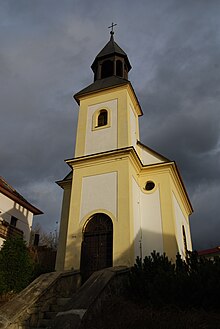
- Chapel of St. Peter and Paul, the first news comes from 1719 when the Pisek Council decided to purchase a bell for the bell tower of St. Peter and Paul in Pasek. In 1926 the chapel received a larger bell.
- Memorial stone for the fallen in World War I, erected in 1920 with the help of compatriots from America
- Memorial stone for František Žák, it was unveiled in 2004
- Crossroads at the southwest exit of the village at the junction of the path to Nuzov, built in 1898
- Crossroads in the southern part of the village, erected in 1894 by the lawyer František Daneš
- Homestead No. 30 in the peasant baroque style
- Chapel in Nuzov
- Lookout tower on Vysoký Kamýk
Sons and daughters of the church
- František Žák, major general and victim of Stalinism
Web links
Individual evidence
- ↑ Český statistický úřad - The population of the Czech municipalities as of January 1, 2019 (PDF; 0.8 MiB)
- ↑ Johann Gottfried Sommer The Kingdom of Bohemia, Vol. 8 Prachiner Circle, 1840, p. 16
- ↑ Sněm království Českého 1878-1882, 3. zasedání, 1. schůze, část 1/2 (from September 24, 1881)


