
Slabčice
| Slabčice | |||||
|---|---|---|---|---|---|
|
|||||
| Basic data | |||||
| State : |
|
||||
| Region : | Jihočeský kraj | ||||
| District : | Písek | ||||
| Area : | 1748 ha | ||||
| Geographic location : | 49 ° 20 ' N , 14 ° 20' E | ||||
| Height: | 439 m nm | ||||
| Residents : | 364 (Jan. 1, 2019) | ||||
| Postal code : | 398 47 | ||||
| License plate : | C. | ||||
| traffic | |||||
| Street: | Podolí I - Dražíč | ||||
| Next international airport : | České Budějovice Airport | ||||
| structure | |||||
| Status: | local community | ||||
| Districts: | 4th | ||||
| administration | |||||
| Mayor : | Jaroslav Bouška (as of 2012) | ||||
| Address: | Slabčice 53 398 43 Bernartice |
||||
| Municipality number: | 549860 | ||||
| Website : | www.slabcice.cz | ||||


.jpg)
Slabčice (German Slabsitz ) is a municipality in the Czech Republic . It is located ten kilometers northwest of Bechyně in South Bohemia and belongs to the Okres Písek .
geography
Slabčice is located in the south of the Milevská pahorkatina belonging to the Central Bohemian hill country. The village is located on the right bank of the Slabčický stream. To the northeast rises the Čepinec (500 m), east of the Na Kopci (498 m), in the southeast of the Tábor (504 m) and northwest of the Dubový vrch (524 m).
Neighboring towns are Široká, Dolní Rastory, Horní Rastory, Kozí Hora and Ovčín in the north, Rakov, Svatkovice and Borovany in the north-east, Nemějice in the east, Drtina, Psohlavec, Smolečské Březí, Dražíčské Březí and Souložnice, Jehnran, Ovovčín and in the south-east and Písecká Smoleč in the southwest, Chřešťovice and Kozín in the west and Strouhy, Hájovna and Olešná in the northwest.
history
_(21).jpg)
Archaeological finds show that the area has been inhabited since the Bronze Age . The most important site is the Tábor hill, on which there was probably a Celtic sanctuary. The thousands of pierced votive objects and remains of stakes found there within a radius of 20 m² suggest that they were hung on sacred trees around a shrine. Barrows from the Hallstatt period were found on the Na Kopci hill .
The first written mention of the village took place in 1379 in a list of all archbishopric lordships commissioned by Archbishop Johann Očko von Wlašim . The register drawn up by the archbishop notary Jindřich Hezlín von Humpolec for the purpose of levying a special tax in support of King Wenceslas IV shows Olešná as one of 33 villages in the Thein domain . On August 20th, 1415 Archbishop Konrad von Vechta had to pledge the rule to Jan von Sobětice as a result of mismanagement. In 1416 the pledge was completely transferred to him.
During the pilgrimages to the mountain ( poutě na hory ) undertaken at the time of the Hussite movement after the restriction of the Hussite church services between Easter 1419 and 1420, sermons were made in the open air on the Tábor. The great meeting with stations on different mountains ended on July 22nd, 1419 on the Tábor with a sermon in front of 42,000 supporters.
After the Battle of White Mountain , the rulership was confiscated and returned as a whole to the Archdiocese of Prague by King Ferdinand II .
In 1840 Slabschitz consisted of 40 houses with 319 inhabitants. Three remote Dominical houses belonged to the village. The parish was Chrashtian . Until the middle of the 19th century, the village always remained subject to the archbishopric Moldau-Thein.
After the abolition of patrimonial formed Slabčice / Slabschitz 1850 a district of the municipality Smoleč in the district administration and the judicial district Písek. In 1920 Slabčice became independent. In 1949 Slabčice was assigned to the Okres Milevsko; after its abolition, it came back to Okres Písek at the end of 1960 , at the same time Nemějice and Písecká Smoleč were incorporated with Březí. The Slavík and Boudy strata to the west of the Vltava Valley were flooded with the Orlík Dam reservoir in the 1960s .
Community structure
The municipality consists of the districts Slabčice Březí, even Smolečské Březí ( birch ), Nemějice ( Nemejitz ) Písecká Smoleč ( Smile sealed ) and Slabčice ( Slabschitz ) well as the stratification of Široká, and Ovčín Souložnice,
Attractions
- Church of St. Joseph, it was built between 1899 and 1900 with donations from American emigrants
- Tábor hill, popularly known as Burkovák, with the remains of a Celtic sanctuary, Tábor was the end point of the Great Assembly of the Hussites in 1419
- Megalithic complex "Kruh" on Tábor near Nemějice, it was created as a modern tourist attraction
- Skály lookout point, northwest of the village on the cliffs above a side bay of the Orlík reservoir . Opposite rises on a spur above the Vltava the Chřešťovice castle stables with the church of John the Baptist from the 14th century
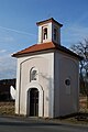
- Chapel in Smolečské Březí
- Chapel of St. John of Nepomuk in Nemějice

St. Joseph Church

Chapel in Smolečské Březí
Chapel of St. John of Nepomuk in Nemějice
.jpg)
_(1.).jpg)
_(29.).jpg)
Web links
Individual evidence
- ↑ Český statistický úřad - The population of the Czech municipalities as of January 1, 2019 (PDF; 0.8 MiB)
- ^ Johann Gottfried Sommer The Kingdom of Bohemia, Vol. 9 Budweiser Kreis, 1840, p. 56