
Kostelec nad Vltavou
| Kostelec nad Vltavou | |||||
|---|---|---|---|---|---|
|
|||||
| Basic data | |||||
| State : |
|
||||
| Region : | Jihočeský kraj | ||||
| District : | Písek | ||||
| Area : | 3281 ha | ||||
| Geographic location : | 49 ° 30 ' N , 14 ° 13' E | ||||
| Height: | 473 m nm | ||||
| Residents : | 392 (Jan. 1, 2019) | ||||
| Postal code : | 398 58 | ||||
| License plate : | C. | ||||
| traffic | |||||
| Street: | Milevsko - Březnice | ||||
| Next international airport : | České Budějovice Airport | ||||
| structure | |||||
| Status: | local community | ||||
| Districts: | 4th | ||||
| administration | |||||
| Mayor : | Pavel Kosík (as of 2012) | ||||
| Address: | Kostelec nad Vltavou 104 398 58 Kostelec nad Vltavou |
||||
| Municipality number: | 549509 | ||||
| Website : | www.kostelecnadvltavou.cz | ||||


Kostelec nad Vltavou , until 1924 Kostelec (German Kosteletz an der Moldau , formerly Kosteletz ) is a municipality in the Czech Republic . It is located twelve kilometers northwest of Milevsko and belongs to the Okres Písek .
geography

Kostelec nad Vltavou is located on a plateau in the west of the Milevská pahorkatina, which is part of the Central Bohemian hill country. The village lies on the right side above the Vltava valley, which is flooded with the Orlík reservoir . To the north, the state road I / 19 runs between Milevsko and Březnice ; in the north-west it runs over the Žďákovský most bridge over the reservoir. The Kostelecký creek rises in the village. The highest point is the Kostelecký vrch ( Kirchberg , 483 m) in the southern part of the village, where the church, the rectory and the cemetery are located. To the southeast is the Silvestr pond, to the south the Horní Oprava and Sobík ponds.
Neighboring towns are Chrást, Ouvary and Žebrákov in the north, Strašná, Radvánov, V Hájku, Pazderna, Slavoňov, Vesec and Kotýřina in the northeast, Kroupov, Přílepov in the east, Novačik, Vlči, Pazdernaky, Zahrádka, Přílepov in the south Les and Jickovice in the south, Na Husárně, Luh, Nevězice , Peklo, Na Pískách in the southwest, Probulov , Višňovka and Staré Sedlo in the west and Hradce, Orlík , Velký Vír and Radava in the northwest.
history
The first documentary mention of Kostelec took place in 1318. In the years 1341 to 1342 the village Kostelec Super Multavia was listed as the property of the Benedictine monastery Břevnov next to Zahrádka, Jickovice, Radvánov and other villages . The Benedictines built a church on the hill behind the village, from which the current name is derived. In addition, the order founded a provost office in Kostelec. In 1406 Andreas Huller acquired the village of Kostelec from Mareš, Jaroslav Litolt and Aleš from Lichtenburg on Bítov and connected it to his rule Worlik . During the Hussite Wars, the monastic properties in Kostelec became extinct and the property became subject to Klingenberg in its entirety . Wenzel Zmrzlík von Schweißing pledged Kostelec and other villages to Christoph von Schwanberg in 1514 . In 1534, he peculiarly acquired the entire Worlik domain. After the Battle of White Mountain , the estate of Peter von Schwanberg was confiscated and in 1621 the Eggenberg owners of the Worlik domain . The Kostelec parish expired in 1623 and was slammed into Kovářov . After the male line of Eggenberg died out in 1717, the Schwarzenberg family inherited their property. The hospital was founded on January 1, 1762 at the instigation of Prince Joseph zu Schwarzenberg by the pastor Johann Adam Swoboda, who also had the rectory and school built on the Kirchberg. In 1837 the village of Kosteletz , located on a hill near the large ponds Sylvester, Woprawa and Sobik, consisted of 40 houses with 213 inhabitants. The parish church of the Nativity of the Virgin Mary, the parish and school were under stately patronage, and there was also a hospital. To the north was a hunter's house ( Hanslovka ). Kosteletz was vicarage for Koste Last shore ( Kostelecké Břehy ) Přilepow ( Prilepov ) Zabrody, Zahradka ( Zahrádka ) Sobědraž, Chomauty ( Sobědražské Břehy ) Schwarzwühr ( Černý Vír ) Itzkowitz and Warta ( Varta ). The parish was Altsattel ( Staré Sedlo ). Until the middle of the 19th century the village remained subject to the Fideikommissherrschaft Worlik, including the allodial estates Zalužan, Zbenitz and Bukowan.
After the abolition of patrimonial Kostelec formed from 1850 with the district Kostelecké Břehy a municipality in the district administration Písek and the judicial district Mirovice. Žďákov was hit by a flood of the Vltava on September 4th and 5th, 1888. The volunteer fire brigade was founded in 1893. From 1919 the community belonged to the Okres Milevsko. In 1921 Kostelec consisted of 61 houses and had 414 inhabitants. Since 1924 the municipality has been using the official name Kostelec nad Vltavou to distinguish it from other communities of the same name . In 1930 411 people lived in the 74 houses in the village. The villages Kostelecké Břehy, Sobědražské Břehy and Žďákov u Starého Sedla in the Vltava Valley were dissolved in 1957 during the construction of the Orlík Dam and later flooded.
In the course of the abolition of the Okres Milevsko, Kostelec nad Vltavou was reassigned to the Okres Písek at the end of 1960 . 1964 Přílepov, Sobědraž (including Sobědražské Břehy), Vesec (with Kotýřina and Slavoňov) and Zahrádka were incorporated. Kotýřina, Slavoňov and Vesec were transferred to Kovářov on March 22, 1990 .
Community structure
The municipality of Kostelec nad Vltavou consists of the districts Kostelec nad Vltavou ( Kosteletz an der Vltava ), Přílepov ( Pschilepow ), Sobědraž ( Sobiedrasch ) and Zahrádka ( Sachradka ) as well as the layers Bohuslavina, Hamersko, Hanslovka, Na Pschilepýskách., , Pazderna, Sádky.
The former districts of Černý Vír ( Schwarzwühr ), Kostelecké Břehy ( Kosteletzer Ufer ), Sobědražské Břehy ( Chomauty ) were flooded after 1957.
Attractions
- Parish Church of the Birth of the Virgin Mary, the former early Gothic building was probably founded at the beginning of the 12th century by the Benedictines of Břevnov and redesigned in baroque style in 1763. The original parish church was closed in 1623 as a branch of the Kovářov parish and later received a local chaplain who was also the hospital chaplain. The oldest and largest bell dates from 1596 and, according to the inscription, was donated by Johann Georg von Schwanberg and his wife Elisabeth Freiin Collona von Fels. In 1787 a parish was set up again in Kostelec. The church is one of the cultural monuments of the Okres Písek.
- Žďákovský most, the bridge of the state road 19 leads at a height of approx. 50 m over the Orlík dam. With a length of 541 m, it is one of the longest single-arch bridges in Europe.
- Local history museum in the former hospital, it was opened in 2008 and is one of the cultural monuments of the Okres Písek.
- Rectory, built in 1762 under pastor Johann Adam Swoboda, cultural monument of the Okres Písek.
- Old school, it was also built in 1762. In 1787 the parish school was rededicated as a public school and expanded in 1876. In 1887 the school building was extended and a kindergarten was opened in 1939. With the other buildings on the Kirchberg, the old school is one of the cultural monuments of the Okres Písek.
- Statue of St. John of Nepomuk, in front of the church. It is one of the cultural monuments of the Okres Písek
- House number 23, birth house of Čeněk Zíbrt
- House number 22, in the peasant baroque style
- Center of Zahrádka, it has been protected as a village monument zone since 1995 because of its baroque farmsteads
- Chapel of St. John of Nepomuk in Sobědraž
- Chapel of the Virgin Mary in Seven Sorrows or Sosnov Chapel on the road between Zahrádka and Hrejkovice
- Chapel in the village square of Zahrádka, built in 1872
- Chapel by the pond near Přílepov, built at the beginning of the 20th century
- Chapel of St. Barbara
- Several wayside crosses
- Attractions
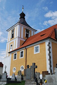
Church of the Birth of Mary

Rectory
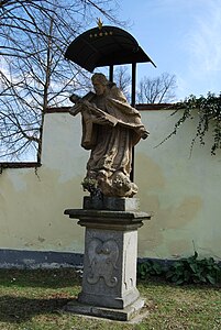
Statue of St. John of Nepomuk

Niche chapel in front of the church
.jpg)
.jpg)
.jpg)
.JPG)
Sons and daughters of the church
- Čeněk Zíbrt (1864–1932), ethnographer, cultural historian and folklorist
Web links
Individual evidence
- ↑ Český statistický úřad - The population of the Czech municipalities as of January 1, 2019 (PDF; 0.8 MiB)
- ^ Johann Gottfried Sommer : The Kingdom of Böhmen, Vol. 8 Prachiner Circle , 1840, p. 62