
Mirovice
| Mirovice | |||||
|---|---|---|---|---|---|
|
|||||
| Basic data | |||||
| State : |
|
||||
| Region : | Jihočeský kraj | ||||
| District : | Písek | ||||
| Area : | 2206 ha | ||||
| Geographic location : | 49 ° 31 ' N , 14 ° 2' E | ||||
| Height: | 433 m nm | ||||
| Residents : | 1,614 (Jan 1, 2019) | ||||
| Postal code : | 398 06 | ||||
| License plate : | C. | ||||
| traffic | |||||
| Street: | Březnice - Milevsko | ||||
| Railway connection: | Zdice – Protivín | ||||
| structure | |||||
| Status: | city | ||||
| Districts: | 9 | ||||
| administration | |||||
| Mayor : | Zdeněk Bárta (as of 2007) | ||||
| Address: | Masarykovo náměstí 38 398 06 Mirovice |
||||
| Municipality number: | 549592 | ||||
| Website : | www.mirovice-mesto.cz | ||||


Mirovice ( pron . [ˈMɪrovɪtsɛ] , Ger . Mirowitz ) is a city in the Czech Republic . It is located 20 kilometers south of Příbram on the Skalice and belongs to the Okres Písek .
geography
Mirovice is located on both sides of the Skalice in the Central Bohemian hill country . In the northeast rises the 515 m high Háj. Through Mirovice for the state road 19 between Březnice and Milevsko and the Rakonitz – Protivín Railway .
Neighboring towns are Myslín and Boješice in the north, Touškov and Zalužany in the northeast, Horosedly and Lety in the east, Dolní Nerestce and Horní Nerestce in the southeast, Kakovice in the south, Slavkovice, Minice and Mišovice in the southwest, Sochovice and Plíškovice in the west and Počaply in the north-west.
history
The settlement was established on the right bank of the Skalice below the early medieval Bozeň castle , nothing of which has survived . The church of St. Kliment was built around 1240 and has been a parish church since 1359.
In 1323 Johann von Luxemburg pledged Mirovice together with the rule of Klingenberg to Peter I. von Rosenberg , who raised Mirovice to market in 1327. Mirovice was temporarily owned by the royal chamber in the 14th and 15th centuries, but was again a pledge of the Rosenbergs. In 1514 Christoph von Schwanberg bought the lordships Worlik and Mirowitz. The existence of Jews in the place has been documented since 1581. During the Thirty Years' War, the market, which had been owned by the Eggenbergers since 1623, suffered several looting and pillage. In 1680 the Jewish community established a cemetery outside the city. After the male line of Eggenberg died out in 1717, the Schwarzenberg family inherited their property in Mirovice. After patrimonial rule was replaced, Mirowitz became an independent town in 1848, with 1,257 people living in 1850.
In 1853 Mirowitz was promoted to town. In 1856 there were 603 Jews living in the Mirowitz district who, in addition to Mirowitz , were also resident in Mirotitz , Warwaschau , Rakowitz , Altsattel and Saluschan . In 1875 operations began on the first section of the Rakonitz – Protivín Railway between Zdice and Protiwin . The railway station was built on the left of the Skalice and a settlement was built around it, which means that Mirovice expanded to the opposite side of the river. In 1900 Mirowitz had 1019 inhabitants.
.jpg)
After the Munich Agreement , the city experienced a strong population increase due to Czechs who had to leave the areas ceded to the German Empire. The Jewish community was wiped out during the Holocaust. German refugees were housed mainly in the school at the beginning of 1945 and at the end of the Second World War more than 2000 people lived in the city. By 1950 this number had fallen back to 1065.
The rabbi's house was demolished in 1950 and the synagogue, which was no longer used after the war, was rebuilt in 1972. The former Jewish quarter fell into disrepair and was demolished or destroyed by renovations.
The Roma children who were murdered in the Lety concentration camp were buried in the Mirovice cemetery; today there is a memorial plaque there.
Local division
The town Mirovice consists of the districts Boješice ( Bojeschitz ) Kakovice ( Kakowitz ) Mirovice ( Mirowitz ) Ohař ( Wohorsch ) Plíškovice ( Plischkowitz ) Ráztely ( Rastel ) retec ( Rech ), Sochovice ( Sochowitz ) and Touškov ( Tauschkow ).
Partner municipality
- Bätterkinden , Switzerland
Attractions
- Church of St. Clement, built around 1240 and 1727 under Joseph Adam zu Schwarzenberg, redesigned in baroque style by the builder Franz Joseph Fortini
- Plague column on the market, created by Johann Georg Schlansowsky in 1717
- Jewish cemetery , one kilometer north of the city, laid out in 1680 and used until the Second World War
- square market place
- Attractions

Mirovice

St. Clement
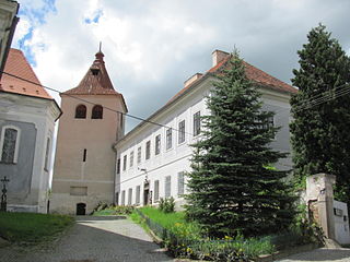
Old church tower and rectory

Jewish Cemetery


.JPG)
.jpg)
sons and daughters of the town
- Antonín Klášterský (1866–1938), Czech poet