
Zalužany
| Zalužany | |||||
|---|---|---|---|---|---|
|
|||||
| Basic data | |||||
| State : |
|
||||
| Region : | Středočeský kraj | ||||
| District : | Příbram | ||||
| Area : | 955 ha | ||||
| Geographic location : | 49 ° 33 ' N , 14 ° 5' E | ||||
| Height: | 466 m nm | ||||
| Residents : | 312 (Jan. 1, 2019) | ||||
| Postal code : | 262 84 | ||||
| License plate : | S. | ||||
| traffic | |||||
| Street: | Prague - Strakonice | ||||
| structure | |||||
| Status: | local community | ||||
| Districts: | 1 | ||||
| administration | |||||
| Mayor : | Zdeněk Soukup (as of 2013) | ||||
| Address: | Zalužany 145 262 84 Zalužany |
||||
| Municipality number: | 541613 | ||||
| Website : | www.obec-zaluzany.cz | ||||


Zalužany (German Saluschan , formerly Zalužan ) is a municipality in the Czech Republic . It is located five kilometers northeast of Mirovice and belongs to the Okres Příbram .
geography
Zalužany is located in the Central Bohemian hill country to the right of the headwaters of the Zalužanský creek. There are numerous smaller ponds in the village and its eastern environs and the Hejný pond to the southeast. To the north rises the Březina (568 m), in the east the Žďár (513 m), southeast the Holý vrch (541 m), in the southwest the Háj (516 m) and the Šibená (484 m) and northwest the Hodijov (518 m) ). State road I / 4 runs on the western outskirts between Prague and Strakonice .
Neighboring towns are Sazka, Kletice, Chraštice , Chraštičky, Vargač and Bukovany in the north, Sedlečko, Holušice, Nová Vachanka, Kozárovice in the northeast, Na Samotě, Anenský Dvůr, Vystrkov and Pukňov in the east, Kožlí , Kubý Vívist, Velkov and Na Zeleném in the south-east, Lety , Pazderna and Dolní Nerestce in the south, Horosedly , Mirovice , Plíškovice, Na Návrší, Podskalí and Myslín in the south-west, Boješice and Touškov in the west and Nestrašovice , Řeteč, Tušovice , Vouškovskéi in the north-west.
history
Archaeological finds show an early settlement of the Zalužany plain. The remains of several round huts with a width of 5 m and a length between 8.25 and 13.5 m from the time after 1000 BC were found on an area of 1000 m². Excavated. In 1926 a silver denarius from the time of Emperor Hadrian was found in a garden .
The present village was probably built by Slavic settlers between the 8th and 10th centuries. The place name is derived from za luhem or za luží ( behind the meadows ). In the 13th century the village was part of the royal castle Vrškamýk .
The first written mention of Zalužany took place in 1291, when Wenceslaus II gave the village together with Tochovice to the Insula Benedictine monastery. From 1313 to 1345 Zalužany again belonged to the Kamýk estates of the Bohemian court chamber. After the renewed separation from the Kamýk goods, Zalužany was divided into two parts. The greater part of Zalužany was sold as a knight's seat. Subsequently, different noble families took turns as owners of the property. A smaller portion was added to the royal castle Worlik as a feudal property and thus enfeoffed various vassals. The creation of a spacious village square in Zalužany has been handed down from 1351. The first written reports about the Zalužan fortress date from the beginning of the 15th century as the seat of Albrecht Schütz von Drahenitz ( Šic z Drahenic ); however, it can be assumed that a wooden noble court had previously stood in their place. At that time, the owner of the Worliker share was the Supreme Mint Master Peter Zmrzlík von Schweißing . Around 1515 Adam Laubsky von Lub ( Loubský z Lub ) acquired the Zalužan fortress. After Messrs. Laubsky von Lub bought the Worliker share from Messrs. Von Schwanberg in 1573, the division of the village was ended. Zalužany was the largest village far and wide at that time.
After the Battle of White Mountain , the Lords of Sternberg bought the estate in 1623. In 1708, Wenzel Adalbert von Sternberg left his heirs a heavily indebted estate, a decrepit village and an uninhabitable fortress. They sold the property to Johann Felix Deym von Střítež in 1715 . In the following twelve years there was strife between the Deym von Střítež and the owners of the Worlik domain . There were disputes over the border and grazing rights, and property infringement lawsuits were also brought. In 1727 the underage Johann Joseph Freiherr Kotz von Dobrz inherited the estate from his aunt Kajetana Valentina Deym, née Kotz. Ten years later he took over the management of the property himself. The barons Kotz von Dobrz had the fortress converted into a renaissance castle. 1767 inherited Johann Joseph's son Franz Dionys Kotz von Dobrz Zalužan. After his death, his widow Marie ran the estate from 1771. In 1775 she married Karl Freiherr Helversen von Helversheim. After 1780, a chalup settlement called Sázky was built north of the village. In 1802, Karl Helversen's son of the same name inherited the estate. Karl Philipp zu Schwarzenberg , who bought the estate in 1804, added it to his Fideikommissherrschaft Worlik .
In 1837 the allodial property Zalužan comprised a usable area of 1805 yoke 330 square fathoms, of which 712 yoke 740 square fathoms belonged to the authorities. The village of the same name and seven houses from Großwühr ( Velký Vír ) and one house each from Kozarowitz and Wystrkow ( Vystrkov ) belonged to the estate . The village of Zalužan , on both sides of Prager Straße, consisted of 88 houses with 148 inhabitants, including six Israelite families. One of Zalužan's houses was directly subordinate to Worlik. In the place there was a stately castle with the closed chapel of the Blessed Virgin Mary, the Augezdetz farm, a sheep farm, a distillery, a potash boiler and the Politschko tavern. To the northwest behind the village was the Israelite cemetery. The parish was Mirowitz . Until the middle of the 19th century, the Zalužan estate formed part of the Worlik Fideikommissherrschaft including the allodial estates of Zalužan, Zbenitz and Bukowan.
After the lifting of patrimonial formed Zalužany t. Zalužany / Zalužan from 1850 with the districts Boješice and Touškov a municipality with 1208 inhabitants in the district administration Březnitz and the judicial district Mirowitz . From 1855 the municipality belonged to the Písek District . In 1869 the municipality of Zalužan requested that it be elevated to a market municipality. Since the village did not have a church, the application was rejected; this then gave rise to the building of the church. In 1880 Zalužany was introduced as an official place name. Between 1880 and 1882 a cemetery was laid north of Zalužany near Sazka. The Jewish community died out in 1890. In 1924, Touškov broke away from Zalužany and formed its own community. In 1932 there were 722 people in Zalužany; in the village there was a post office, a telegraph office, a telephone exchange, a Catholic church, a synagogue , a Jewish cemetery and a poor house. In 1960 the community was assigned to the Okres Příbram.
Community structure
No districts are shown for the municipality of Zalužany. The settlement Sazka ( Sarka ) belongs to Zalužany .
Attractions
- Zalužany Castle, its origins lie in a stone fortress built for Albrecht Schütz von Drahenitz. This was expanded in the 16th century by the Laubsky von Lub. Between 1650 and 1660, the Lords of Sternberg had the eastern wing of the building facing the village, including the gate and drawbridge, removed and the moat filled. A farm yard was built in its place. At that time only the south wing was inhabited, the brewery was in the north wing. Later the fortress was no longer inhabited. After 1727 the Kotz von Dobrz rebuilt the abandoned single-storey fortress as a family seat into a two-story renaissance castle. The castle chapel of the Virgin Mary, which was later dedicated to St. Anthony of Padua was consecrated. From 1775 the castle was modified in the Rococo style under Karl Helversen von Helversheim. From 1804 the castle belonged to the Prince of Schwarzenberg , who owned it until 1922. Until 1889 a chaplain was appointed to the chapel , who had his residence in the castle. The castle was renovated between 1920 and 1924. In the course of the land reform in 1924 Václav Biskup from Žbonín acquired the estate. In 1948 the chateau was nationalized and in 1974 transferred to the legal ownership of the Příbram District Cultural Center. An exhibition of the Muzeum středního Povltaví was set up on the first floor . The second floor was used by the National Gallery and the Prague City Museums for their two-year art exhibitions, České výtvarné umění 19. století . After the Velvet Revolution , the Biskup family got the castle back. After the restoration, the castle was leased to Carl Albrecht Waldstein between 1997 and 2005 as his family seat. Since 2009 it has also been used publicly for weddings and concerts. The castle, which is surrounded by an English landscape park, is protected as a cultural monument.
- Church of St. Karl Borromeo, the classicist building was built in the years 1872–1874. It is currently not open to the public.
- Statues of St. Anna and Johannes von Nepomuk, in front of the church, created in the middle of the 18th century
- Cemetery chapel of St. Exaltation of the cross, built in the 19th century
- Jewish cemetery at the northern exit of the village, it was built before 1724. 70 gravestones have been preserved on the 1597 m² area. After the Jewish community of Zalužany died out in 1890, the cemetery was maintained by the Jewish community of Březnice until the German occupation . The cemetery wall and the ceremonial hall were demolished around 1980. The cemetery is a national cultural monument.
- Former synagogue , now used as a storage room
- Attractions
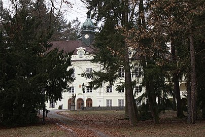
Zalužany Castle
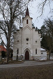
Church of St. Karl Boromäus
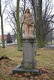
Statue of St. Anna

Former synagogue


_(6).jpg)

Individual evidence
- ↑ Český statistický úřad - The population of the Czech municipalities as of January 1, 2019 (PDF; 7.4 MiB)
- ^ Johann Gottfried Sommer The Kingdom of Bohemia, Vol. 9 Budweiser Kreis, 1840, pp. 46–48
- ^ Johann Gottfried Sommer The Kingdom of Bohemia, Vol. 9 Budweiser Kreis, 1840, p. 66