Pičín
| Pičín | ||||
|---|---|---|---|---|
|
||||
| Basic data | ||||
| State : |
|
|||
| Region : | Středočeský kraj | |||
| District : | Příbram | |||
| Area : | 1425.5966 ha | |||
| Geographic location : | 49 ° 45 ' N , 14 ° 3' E | |||
| Height: | 472 m nm | |||
| Residents : | 662 (Jan. 1, 2019) | |||
| Postal code : | 262 25 | |||
| License plate : | S. | |||
| traffic | ||||
| Street: | Hluboš - Obořiště | |||
| structure | ||||
| Status: | local community | |||
| Districts: | 1 | |||
| administration | ||||
| Mayor : | Lenka Kupková (as of 2015) | |||
| Address: | Pičín 154 262 25 Pičín |
|||
| Municipality number: | 541052 | |||
| Website : | www.picin.cz | |||
Pičín (German Pitschin ) is a municipality in the Czech Republic . It is located seven kilometers northeast of the city center of Příbram and belongs to the Okres Příbram .
geography
Pičín is located at the southern foot of the Hřebeny ( Brdykamm ) in the Dobříšská pahorkatina ( Dobrischer hill country ). The village is located on the upper reaches of the Kotenčický creek, which is dammed in Pičín in the Příkop and Antonín ponds. To the north rise the Lhotka (543 m nm), the Holý vrch (632 m nm), the Provazec (639 m nm), the Písek (691 m nm) and the Malý vrch (628 m nm), in the northeast the Kuchyňka ( 636 m nm) and the Kouty (507 m nm), east of the Kamenný vrch (486 m nm) and the Sedlo (471 m nm), in the southeast of the Katov (487 m nm), south of the Kosovec (505 m nm), in the southwest the Dráska (527 m nm) and northwest of the Malý Chlum (591 m nm). In the north is the Lhotka game reserve.
Neighboring towns are Chlum and Vršek in the north, Buková u Příbramě , Vršek and Rosovice in the north-east, Kamenný Dvůr and Obořiště in the east, U Kostinků, Kotenčice , Dlouhá Lhota and Suchodol in the south-east, Líha , Občov and U Budských, in the south, Skorotín, in the south. Trhové Dušníky and Kardavec in the south-west, Loudilka, Zděný Mlýn, Bratkovice and Hluboš in the west and Velcí, Jince , Čenkov , Běřín, Komorsko and Náves in the north-west.
history
The Pičín estate once belonged to the royal estates and was given to the Bavor von Strakonitz by King Ottokar II. Přemysl . The first written mention of the village Pičín with church and parish was made in 1289 as the property of Bavor II von Strakonitz. His son Wilhelm von Strakonitz renounced the church patronage in 1320 and left it to the Maltese Strakonitz . Later, the Bavor von Strakonitz also donated the Pičín estate to the Order of Malta, who owned it until 1373. At that time the fortress became a mansion; from 1373 it belonged to the Slavimír of Pičín, the subsequent owner was from 1393 Albert von Pičín. From 1410 Beneš von Hořovice and Rabštejn owned the Pičín estate. The Pičín Fortress was first mentioned in writing in 1473 as the property of Peter Kořenský of Terešov. Before 1493 he sold Pičín to Ulrich Bechinie von Lazan . This founded the Pitschiner family line, which held the estate for several generations. In the course of the division of the estate under Ulrich's numerous sons, Dlouhá Lhota was separated from Pičín in 1515 as a country estate. From 1537 Pičín belonged to the Oberstlandschreiber Johann Bechinie von Lazan († 1547) and from 1554 to the royal chamberlain Peter Bechinie von Lazan († 1561). In 1571, the captain of the New Town of Prague, Adam Mucha von Buková, bought the Pičín estate. Pičín later returned to Messrs Bechinie von Lazan. In 1592 Juliane Borowska von Lazan bequeathed her goods Bukowa , Wobecnitz , Deutsch Lhota , Pitschin, Rosowitz and Kotentschitz to her daughter Ludmilla. The captain of the Podbrder district, David Bechinie von Lazan († 1611) and Nikolaus Bechinie von Lazan belonged to the following owners. After the Battle of the White Mountain in 1623, the property of Nikolaus Bechinie von Lazan was confiscated because of his participation in the class uprising . He was later pardoned and his property returned. In 1627 he sold the rule to Wenzel Dubsky von Wittenau ( Václav Dubský z Vitiněvsi ). Between 1689 and 1691 Johann Ferdinand Dubsky von Wittenau founded a monastery with a chapel of St. Anthony of Padua. Pitschin belonged to the Podbrder Kreis until 1714, after which it became part of the Berauner Kreis . The Dubsky von Wittenau family held the Pitschin estate until 1740. Karl Bechinie von Lazan auf Hlubosch then bought the estate, which he sold to the barons Hochberg von Hennersdorf in 1741 . They also acquired the Hlubosch estate in the 1770s and merged both estates to form the Hlubosch rule. Pitschin Monastery was closed in 1786 as part of the Josephine reforms , and its buildings were later demolished. With imperial approval, Anton Hochberg von Hennersdorf had the rule played out in a lottery on November 30, 1816 . The big ticket was drawn by a Viennese citizen, who then sold the rule to Otto Victor I von Schönburg-Waldenburg . In 1826 Prince Otto Victor sold the rule to his sister-in-law Louise Princess zu Schönburg-Hartenstein , née von Schwarzenberg , the wife of his brother Eduard. In 1835 Princess Louise sold the rule of Hlubosch to the former governor of the Prussian principality of Neuchâtel , Ludwig von Pourtalès .
In 1846 the Pitschin estate comprised a usable area of 3,052 yoke 309 square fathoms. The village of Pitschin or Pičjn consisted of 67 houses with 569 inhabitants, including a Jewish family. The parish church of the Birth of Mary, the parish and the school were under the patronage of the Maltese Grand Priory. There was also an inn in the village. The old lock had been converted into a bulk floor. On the other side was the Nawes ( Náves ) magistrate's farm with a sheep farm. In Pitschin was one of the dominion's three forest districts, which cultivated an area of 797 yoke 521 square fathoms. Pitschin was the pastor for Teutsch-Pasek , Bukowa , Kotentschitz , Lyha , Občow , Dubenetz , Suchodol , Skalka and 43 houses in Rossowitz . Until the middle of the 19th century, Pitschin remained subject to the rule of Hlubosch.
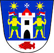
After the abolition of patrimonial formed Pičín / Pitschin 1850 with the hamlet Žírovy a municipality in the judicial district Příbram. From 1868 the municipality belonged to the Příbram District . In 1932 there were 454 people living in Pičín (with Žirovy). The community has had a coat of arms and a banner since 2011.
Community structure
No districts are shown for the municipality of Pičín. Basic settlement units are Pičín ( Pitschin ), Vršek and Žírovy ( Schirow ). The settlement of Chlum and the single-layer Hřebeny also belong to Pičín .
Attractions
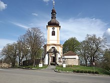
- The Church of the Assumption of the Virgin was probably built in the middle of the village on a hill in the 13th century and in 1320 was given to Strakonice, who came from Malta . In the 18th century the tower and the choir gallery were added to the west side. In the presbytery there are remains of Gothic wall paintings from the 1340s depicting the flagellation of Christ and hell. The church was the final resting place of numerous members of the Pitschiner line of the Bechinie von Lazan. The cemetery was around the church.
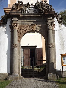
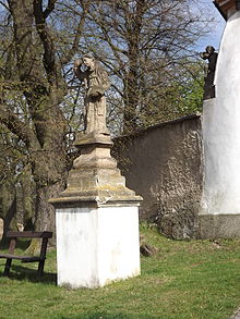
- Old cemetery, it's surrounded by a wall. The entrance to the cemetery was through a baroque columned portal from 1691 with the coat of arms of the Dubsky von Wittenau, which was originally located in the Pičín monastery and was moved to the cemetery entrance after its abolition. On the side of the entrance to the church are the statues of St. John of Nepomuk and Anthony of Padua, who originally stood in the monastery.
- Fortress Pičín, opposite the church on the bank of the Příkop pond on the farm area. It was probably built in the 13th century and was first mentioned in writing in 1473. In the 16th century, the Lazan Bechinie had the fortress rebuilt in the Renaissance style and raised to two floors. After the renovation, the fortress was also called a castle. The square complex with an asymmetrically arranged passage lost its importance as a manor house after the union of the Pičín Manor with the Hluboš Manor and was converted into a granary in the 18th century.
- Rectory, next to the fortress
- Kuchyňka nature reserve with the remains of the original rubble forest on the mountain of the same name in Brdy
- Exhibition Pohádková země ( Fairy Tale Land ) with characters by Vítězslava Klimková
Web links
Individual evidence
- ↑ http://www.uir.cz/obec/541052/Picin
- ↑ Český statistický úřad - The population of the Czech municipalities as of January 1, 2019 (PDF; 7.4 MiB)
- ^ Johann Gottfried Sommer The Kingdom of Bohemia, vol. 16 Berauner Kreis, 1849, pp. 247-252
- ↑ http://picin.cz/detail.php?ID=4&anketa_nazev=&anketa_ukonceni=ano
- ↑ http://www.uir.cz/zsj-obec/541052/Obec-Picin
- ↑ http://pohadkovazeme.cz/PZ/picin/picin.htm


