
Dražíč
| Dražíč | |||||
|---|---|---|---|---|---|
|
|||||
| Basic data | |||||
| State : |
|
||||
| Region : | Jihočeský kraj | ||||
| District : | České Budějovice | ||||
| Area : | 1135 ha | ||||
| Geographic location : | 49 ° 18 ' N , 14 ° 23' E | ||||
| Height: | 447 m nm | ||||
| Residents : | 237 (Jan 1, 2019) | ||||
| Postal code : | 373 04 | ||||
| License plate : | C. | ||||
| traffic | |||||
| Street: | Bernartice - Bechyně | ||||
| Next international airport : | České Budějovice Airport | ||||
| structure | |||||
| Status: | local community | ||||
| Districts: | 4th | ||||
| administration | |||||
| Mayor : | Alena Dědičová (as of 2018) | ||||
| Address: | Dražíč 57 375 01 Týn nad Vltavou |
||||
| Municipality number: | 549371 | ||||
| Website : | www.drazic.cz | ||||
| Location of Dražíč in the České Budějovice district | |||||

|
|||||


Dražíč (German Draschitz ) is a municipality in the Czech Republic . It is located seven kilometers west of Bechyně in South Bohemia and belongs to the Okres České Budějovice .
geography
Dražíč is located in the south of the Milevská pahorkatina belonging to the Central Bohemian hill country. The village is located in the basin of a small stream on a terrace on the right-hand side above the Bílinský potok valley. The Babina (467 m) rises to the southeast, the Chrášťanská hůrka (479 m) to the south, the Chlum (509 m) to the southwest and the Tábor (504 m) to the northwest. The Plziny Nature Park extends to the east. To the southeast is the Šternberský rybník pond, to the west is the Vltava valley flooded with the Orlík dam . The road II / 105 between Bernartice and Týn nad Vltavou leads through Dražíč , from which the road II / 135 branches off to Bechyně in the village.
Neighboring towns are Karlov, Nepomuk and Borovany in the north, Rataje , Soví, Haškovcova Lhota and Radětice in the northeast, Senožaty, Hutě and Bechyně in the east, Koudelka, Hemera, U Bártů, Šternberk, U Kutišů, Hvožďany and Nuziceť in the southeast, Chrášťany in the southeast, south , Doubravka in the southwest, Chlum, Vranov and Dražíčské Březí in the west and Smolečské Březí, Drtina and Nemějice in the northwest.
history
Evidence of an early settlement of the area is a Middle Bronze Age barrow southwest of the village on the slope of the Chlum in the Karlovka forest.
The first written mention of Drazicz was in 1379 in the episcopal land register . At that time the village between the episcopal manor was Thein and the Lords of Sternberg associated Castle Bechyně shared. The Theiner part comprised six properties. In the 15th century the rule of Týn nad Vltavou and with it the part belonging to it from Drazicz fell to the Čabelický von Soutice, who united it with the Bechiner part and had a fortress built in the 16th century. After the Battle of the White Mountain , the Draschitz estate was confiscated because the owner Johann Swatowský had participated in the class uprising of 1618. On February 25, 1623 the Hofkammer sold the estate to Adam Lipowsky for 5220 shock. Theresia Countess von Pötting from 1720 and the Barons von Tam from 1729 belonged to the subsequent owners of the estate. In 1751 the Bechiner Gau was divided between the Tabor and Budweiser districts, with Draschitz belonging to the former. After Johann Wenzel von Tam's death, his brother Prokop inherited the estate before 1789. He sold it to Captain Anton von Klem in 1802. During the Napoleonic Wars, French troops left damage in Týn nad Vltavou, Chrášťany and Dražíč. In 1804 the Prague citizen Michael Pentzsch bought the estate and two years later sold it to the Imperial and Royal Major General and Colonel Hereditary Land postmaster Karl Reichsfürst von Paar , who connected Draschitz with his rule Bechin . The brewery belonging to the Allodialgut Draschitz was closed after the union with Bechin. After the death of Karl von Paars, his son of the same name, the Imperial Chamberlain and Colonel Hereditary Country Postmaster Karl Fürst von Paar inherited the goods on December 30, 1819. In 1825 the estate covered an area of 1543 yoke and 1466 square fathoms. The Good Draschitz had in the year 1840 725 Czech-speaking subjects, including an Israelite family Draschitz, and included the villages Draschitz, Nepomuk, Wranow and the stratification of Zelena and Lipowsko. The village of Draschitz / Dražice at that time consisted of 53 houses with 428 inhabitants. Ten of the houses were subject to the archbishopric of Thein . In Draschitz there was a castle with an apartment for the economic clerk, the public castle chapel St. Nikolaus, a manorial farm with sheep, a manorial distillery and a dominical potash boiler. The former Bruna inn and a stately hunter's house on the Chlum were situated apart. The parish was Chrashtian .
Up until the middle of the 19th century, Draschitz always formed a country table allodial property, which was administered with the allodial rule of Bechin as an overall dominium. After the abolition of patrimonial formed Dražice / Draschitz with the districts Březí / Březy , Nepomuk and Vranov / Wranow 1850 a municipality in the district administration and the judicial district Milevsko / Mulhouse. At the beginning of the 20th century, Dražič was used as the Czech place name and Dražíč since 1924 .
In 1948 the municipality was assigned to the Okres Týn nad Vltavou after the Okres Milevsko was abolished. This was dissolved in 1960, with Dražíč part of the Okres Písek . The municipality Dražíč changed on January 1, 2007 in the Okres České Budějovice . In 2011 Dražíč was the winner of the national village of the year competition .
Community structure
The municipality Dražíč consists of the districts Březí, also Dražíčské Březí ( Bries ), Dražíč ( Draschitz ), Karlov-Nepomuk ( Nepomuk ) and Vranov ( Wranow ) as well as the settlement Chlum and the single layer U Pitrů.
Attractions
- Baroque Dražíč Castle, the single-storey building with a rectangular floor plan was created at the beginning of the 18th century from the renaissance festivals of Lords Čabelický from Soutice. The baroque palace chapel of St. Nikolaus was built on the west side under Theresia Countess von Pötting. After the Second World War, the castle served as a warehouse. Today it is privately owned again and is not accessible.
- Baroque chapel of St. John of Nepomuk, south of the village on the road to Chrášťany, built in the first half of the 18th century
- Niche chapel of St. Guardian angel on the road to Nemějice, erected at the transition from the 19th to the 20th century.
- The Lipan Brewery ( Pivovarský dvůe Lipan ), the microbrewery with an attached restaurant, distillery and guesthouse opened in autumn 1995 in the restored building of the former manorial distillery. The light and dark Lipan lager brewed here is tapped directly from the brewery tanks in the restaurant.
- Tábor hill, popularly known as Burkovák, with the remains of a Celtic sanctuary, Tábor was the end point of the Great Assembly of the Hussites in 1419
- Attractions
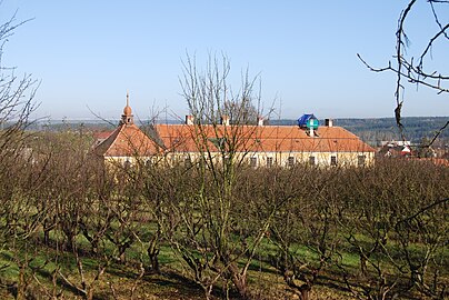
Dražíč Castle
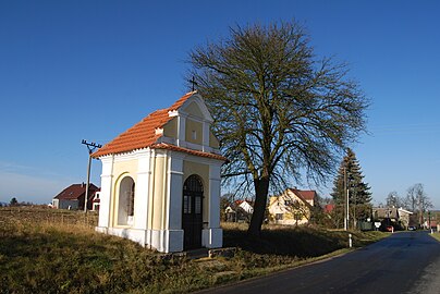
Chapel of St. John of Nepomuk

Lipan Brewery Farm
.JPG)
.JPG)
.JPG)
Individual evidence
- ↑ http://www.uir.cz/obec/549371/Drazic
- ↑ Český statistický úřad - The population of the Czech municipalities as of January 1, 2019 (PDF; 0.8 MiB)
- ↑ Johann Gottfried Sommer The Kingdom of Bohemia, Vol. 10 Taborer Kreis, 1842, pp. 26, 35-37
- ↑ http://www.uir.cz/casti-obce-obec/549371/Obec-Drazic