Čejkovice u Hluboké nad Vltavou
| Čejkovice | ||||
|---|---|---|---|---|
|
||||
| Basic data | ||||
| State : |
|
|||
| Region : | Jihočeský kraj | |||
| District : | České Budějovice | |||
| Area : | 956 ha | |||
| Geographic location : | 49 ° 1 ' N , 14 ° 23' E | |||
| Height: | 389 m nm | |||
| Residents : | 380 (Jan. 1, 2019) | |||
| Postal code : | 373 41 | |||
| License plate : | C. | |||
| traffic | ||||
| Street: | Dasný - Břehov | |||
| Next international airport : | České Budějovice Airport | |||
| structure | ||||
| Status: | local community | |||
| Districts: | 1 | |||
| administration | ||||
| Mayor : | Pavel Chaloupek (as of 2018) | |||
| Address: | Čejkovice 64 373 41 Hluboká nad Vltavou |
|||
| Municipality number: | 544329 | |||
| Website : | www.cejkovice-cb.cz | |||
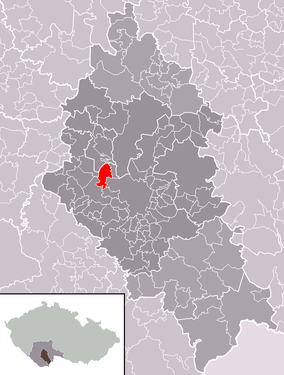
| Location of Čejkovice in the České Budějovice district | ||||

|
||||
Čejkovice (German Tschejkowitz ) is a municipality in the Czech Republic . It is located eight kilometers northwest of Budweis in South Bohemia and belongs to the Okres České Budějovice .
geography
Čejkovice is located on the left side of the Dehtářský creek in the Zbudovská Blata region in the Budweiser Basin. There are numerous ponds in the vicinity of the village; the Bezdrev stretches to the north , the Čejkovický rybník to the southeast, the Blatec and Dolní Mlýnský rybník to the south, the Picinka and the Dehtář to the southwest . The E 49 / I / 20 runs north of Čejkovice between Budweis and Vodňany .
Neighboring towns are Češnovice, Zálužice and Bezdrev in the north, Vondrov, Ohrada , Hluboká nad Vltavou and Podskalí in the north-east, Dasný , Trögrův Dvůr and České Vrbné in the east, Hvízdal, Nové Dvory and Haklošta, Dvoryjar Ba-east in the east Branišov , Jednoty, Dubné and Křenovice in the south, Jaronice and Žabovřesky in the south-west, Na Drahách, Dehtáře and Břehov in the west and Picina, Suchá, Malé Chrášťany and Pištín in the north-west.
history
The first written mention of the village of Czeykowycz was in the Český Krumlov land register in 1400 . The robber Jakoubek from Čejkovice is listed in the Rosenberg execution book in 1423. The owners of most of the village were the Vladiken Kunasch von Maclowitz ( Kunášové z Machovic ) on Machowitz ( Machovice ). A small proportion belonged to Budweiser citizens. Owners of this part were u. a. at the beginning of the 15th century Nikolaus Faulfisch ( Mikuláš Faulfiš ) and at the transition to the 16th century the Puklitz von Wstuch family ( Puklice ze Vstuh ), who bequeathed him to Johann Eckhard von Urtinowitz ( Jan Ekhard z Urtvinovic ). Urtinowitz sold this part to the city of Budweis before 1545, from then on the income was used to pay the clergy at the three parish churches of St. Prokop, St. Nicholas and St. Wenzel.
Between 1585 and 1589 Heinrich Kunasch von Maclowitz ( Jindřich Kunáš z Machovic ) had the renaissance fortress Wildstein ( Vildštejn ) built in Čejkovice . Georg Jaroslaw Kunasch von Maclowitz ( Jiří Jaroslav Kunáš z Machovic ) sold the Machowitz estate in 1687 to Ferdinand Prince zu Schwarzenberg , who added the associated goods, including most of Čejkovice, to his dominion in Frauenberg . In 1840 Čeykowitz or Čegkowitz / Čeykowice consisted of 36 houses with 315 German and Bohemian-speaking inhabitants. Six houses in the village were subject to the city of Budweis . In the village there was a private school, a manorial farm, a sheep farm and an inn. The parish was Pishtin . Until the middle of the 19th century, the village was always subject to the Frauenberg rule.
After the abolition of patrimonial formed Čejkovice / Čeykowitz 1850 a municipality in the district of Budweis and the judicial district of Frauenberg . In 1910 there were 377 Czech-speaking residents in the village. On April 1, 1943 the incorporation to Dasný took place, it was repealed on August 1, 1945 after the end of the Second World War .
Community structure
No districts are shown for the municipality of Čejkovice.
Attractions
- Baroque Meierhof from the 17th century
- Timbered barn at the southern exit of the village
- Chapel of St. John of Nepomuk in the village square, built in the first half of the 19th century
- Farmsteads in the South Bohemian peasant baroque
- Wayside shrine on the dirt road to Pištína
- Memorial stone for the fallen of World War I, unveiled in 1921
- Memorial stone for Bohuslav Tvrdý , north of the village on the E 49 between Dasný and Češnovice; At this point the conductor and composer died on July 29, 1946 in a traffic accident
- Machovice Castle , one and a half kilometers south of the village by the Motovidlo pond
Individual evidence
- ↑ http://www.uir.cz/obec/544329/Cejkovice
- ↑ Český statistický úřad - The population of the Czech municipalities as of January 1, 2019 (PDF; 0.8 MiB)
- ^ Johann Gottfried Sommer : The Kingdom of Bohemia; Represented statistically and topographically. Ninth volume. Budweiser district. Verlag Friedrich Ehrlich, Prague 1841, p. 48, limited preview in the Google book search.
- ↑ http://rodopisna-revue-online.tode.cz/jihogen/c_soubory/jih_cejkovice.jpg
- ↑ http://rodopisna-revue-online.tode.cz/jihogen/c.htm


