
Římov
| Římov | |||||
|---|---|---|---|---|---|
|
|||||
| Basic data | |||||
| State : |
|
||||
| Region : | Jihočeský kraj | ||||
| District : | České Budějovice | ||||
| Area : | 1528 ha | ||||
| Geographic location : | 48 ° 51 ' N , 14 ° 29' E | ||||
| Height: | 471 m nm | ||||
| Residents : | 918 (Jan 1, 2019) | ||||
| Postal code : | 373 24 | ||||
| License plate : | C. | ||||
| traffic | |||||
| Street: | Český Krumlov - Ledenice | ||||
| structure | |||||
| Status: | local community | ||||
| Districts: | 6th | ||||
| administration | |||||
| Mayor : | Miroslav Slinták (as of 2018) | ||||
| Address: | Náměstí J. Gurreho 2 373 24 Římov |
||||
| Municipality number: | 545007 | ||||
| Website : | www.rimov.cz | ||||
| Location of Římov in the České Budějovice district | |||||

|
|||||


Římov (German Rimau ) is a municipality in the Czech Republic . It is located 14 km south of České Budějovice and belongs to the Okres České Budějovice .
geography
Římov is located below the Římov reservoir on the Malsch . Neighboring towns are Borek and Hamr in the north, Dolní Stropnice and Pašinovice in the northeast, Dolni Řimov and Branišovice in the east, Mokrý Lom in the southeast, Kladiny and Hrachovy Hory in the south, Velešín , Holkov and Horní Vesce in the southwest, Dolní Vesce and Horní Římovice in the west as well as Krasejovka, Bartochov and Otmanka in the northwest.
history
The Římov settlement was probably founded in the 13th century and belonged to families from the lower nobility. The first written mentions of Římov come from the years 1383 (Oberrimau) and 1395 (fortress in Unterrimau). In 1626 Římov passed to Ulrich von Eggenberg on Krumau . Eggenberg donated the Římov estate to the Krumlov Jesuit College . The Jesuits made Římov a pilgrimage center and in 1648 built a Way of the Cross with 25 stations.
Community structure
The municipality of Římov consists of the districts Branišovice ( Branschowitz ), Dolní Stropnice ( Stropnitz ), Dolní Vesce ( Lower Wesce ), Horní Vesce ( Upper Wesce ), Kladiny ( Kladenin ) and Římov ( Rimau ) as well as the residential areas Betlém, Hamr, Klady, Mlejnek, U Mareše, Větrník and Želivy. The core village consists of the localities Dolní Římov ( Lower Rimau ) and Horní Římov ( Upper Rimau ). Basic settlement units are Betlém, Branišovice, Dolní Stropnice, Dolní Vesce, Horní Vesce, Kladiny and Římov.
The municipality is divided into the cadastral districts Branišovice u Římova, Dolní Stropnice and Římov.
Attractions
- Holy Spirit Church
- Listed, around 650 year old linden tree in front of the church
- Castle in Dolní Římov, residence of the Jesuits
Way of the Cross
The baroque Way of the Cross is north of the village. It consists of 25 stations on a circular route of around 4 km in length. He recreates the Passion of Christ in Jerusalem. The sacred small buildings fit into the landscape around Římov. Every Palm Sunday afternoon, believers and pilgrims gather in front of the church to walk the traditional Way of the Cross together. Some of the otherwise closed chapels are unlocked and crossed by the procession participants, so that this is the only day of the year on which the interior of these chapels can also be seen. On the other days of the year, too, the Way of the Cross invites you to take a nice walk through partly open, partly wooded terrain.
Maltsch reservoir
The dam Římov was built in the years 1971-1978 and dams the river Malše (Maltsch) to a storage lake. This is mainly used as a drinking water reservoir for the water supply to South Bohemia, especially from České Budějovice (Budweis). The minimum continuous flow in the run under the dam is 650 l / s. The reservoir is 13 km long and the flood area is 210 ha. In the event of flooding, however, priority must be given to draining the water gently through the drainage device so that the dam body is not damaged. Therefore, the Římov water reservoir cannot do much to limit the flooding on the Malše.
Partner communities
- Albrechtsberg on the Great Krems , Austria
Web links

Market square in Římov

Castle in Dolní Římov

Entrance gate to the church area

Listed linden tree in front of the church
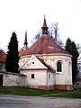
Loretto Chapel at the Heiliggeist Church

Station of the Cross Loučení Panny Marie s Ježíšem ( Mary's Farewell to Jesus )

Station of the Cross Popravní brána ( Court Gate )

Way of the Cross to the Holy Sepulcher

Ímov dam

Reservoir with tower for drinking water extraction

Overflow of the dam


Individual evidence
- ↑ http://www.uir.cz/obec/545007/Rimov
- ↑ Český statistický úřad - The population of the Czech municipalities as of January 1, 2019 (PDF; 0.8 MiB)
- ↑ http://www.uir.cz/casti-obce-obec/545007/Obec-Rimov
- ↑ http://www.uir.cz/zsj-obec/545007/Obec-Rimov
- ↑ http://www.uir.cz/katastralni-uzemi-obec/545007/Obec-Rimov