
Litvínovice
| Litvínovice | |||||
|---|---|---|---|---|---|
|
|||||
| Basic data | |||||
| State : |
|
||||
| Region : | Jihočeský kraj | ||||
| District : | České Budějovice | ||||
| Area : | 582 ha | ||||
| Geographic location : | 48 ° 58 ' N , 14 ° 27' E | ||||
| Height: | 389 m nm | ||||
| Residents : | 2,526 (Jan 1, 2019) | ||||
| Postal code : | 370 01 | ||||
| License plate : | C. | ||||
| traffic | |||||
| Street: | Ceske Budejovice - Velešín | ||||
| Next international airport : | Budweis airport | ||||
| structure | |||||
| Status: | local community | ||||
| Districts: | 3 | ||||
| administration | |||||
| Mayor : | Alena Nováková (as of 2018) | ||||
| Address: | Litvínovice 39 370 01 České Budějovice |
||||
| Municipality number: | 544795 | ||||
| Website : | www.litvinovice.cz | ||||
| Location of Litvínovice in the České Budějovice district | |||||

|
|||||


Litvínovice (German Leitnowitz ) is a municipality in the Czech Republic . It is located two and a half kilometers southwest of the city center of Budweis in South Bohemia and belongs to the Okres České Budějovice .
geography
Litvínovice is located on the left side of the Vltava in the Budweiser Basin . The village extends in the basin of the Vltava tributary Litvínovický potok, which is dammed west of the place in the ponds Horní litvínovický rybník, Prostřední litvínovický rybník and Dolní litvínovický rybník. The hill Švábův hrádek (428 m) rises to the northwest. Road I / 3 / E 55 runs on the eastern edge of the village between České Budějovice and Velešín . The area of the České Budějovice airport extends to the south and south-west .
Neighboring places are Čtyří Dvory and sídliště Šumava in the north, Budweis - Vnitřní město and Stromovka in the north-east, České Budějovice-Linecké předměstí in the east, Stecherův Mlýn and Rožnov in the south-east, Planá in the south, Homole and Novory- west in the west U Cihelny, U Lesa and Branišov in the northwest.
history
Lutwinouich was first mentioned in writing in 1259 in a Wok von Rosenberg document about the transfer of the tithe from several villages to the newly founded Hohenfurth monastery . Later the city of Budweis acquired the village. In 1498, King Vladislav II Jagiello confirmed the town's "longstanding ownership" of the villages of Wrata , Wesce ( Vesce ), Pucharky ( Pohůrka ), Dubiczen , Lince ( Hlinsko ), Mlade ( Mladé ), Wrben německá or Suchowrbnj ( Suché Vrbné ) , Rožnow ( Rožnov ), Litwinowice, Ssindlowy Dwory ( Šindlovy Dvory ), Haklowy Dwory ( Haklovy Dvory ) and Wrben česká ( České Vrbné ). The villages were entered in the land table in 1543 as the property of the royal city of Budweis. In 1840 Leitnowitz / Litwinowice or Litmanice consisted of 29 houses with 201 inhabitants. The rustic mill Fürstenmühle ( Stecherův Mlýn ) , located southeast on the Vltava, belonged to the place . The village was parish to the Budweiser Domkirche St. Nikolaus. Until the middle of the 19th century the village was always subject to the city of Budweis.
After the abolition of patrimonial formed Leitnowitz / Litvínovice 1850 Town of Rožnov / Strodenitz in the district administration and the judicial district Budějovice / Budweis. In 1867 the village broke away from Rožnov and forms its own municipality with the single-layer Lannas sawmill ( Stecherův Mlýn ). In 1910 there were 453 residents in Leitnowitz / Litvínovice , 345 of whom were Germans and 108 Czechs. The village belonged to the German language island around the city of Budweis. At the beginning of 1952 Litvínovice was incorporated into České Budějovice, from May 17, 1954, the village became independent again. On June 12, 1960 the incorporation of Šindlovy Dvory and Mokré took place. Since April 5, 2007, the community has had a coat of arms and a banner.
Meteorological station
In the first half of the 20th century, there was a weather station at the settlement of Stecherův Mlýn. On February 11, 1929, the high school professor and amateur meteorologist Jaroslav Maňák from Budweis measured a new cold record of −42.2 ° C in Czechoslovakia, which is still there. The extreme cold value was measured in an inversion weather situation and a high snow cover, and the measuring station was located near the water.
Community structure
The municipality Litvínovice consists of the districts Litvínovice ( Leitnowitz ), Mokré ( Gauendorf ) and Šindlovy Dvory ( Schindelhöf ) and the settlement of Stecherův Mlýn. Basic settlement units are Litvínovice, Mokré, Mokré-východ and Šindlovy Dvory.
Attractions
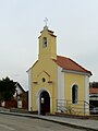
- Chapel in Litvínovice, built in 1861. In 2004, the outer skin was renovated with the support of former German residents.
- Chapel in Šindlovy Dvory
- Chapel in Mokré
- Farmsteads with decorative elements of the peasant baroque

Chapel in Litvínovice
Chapel in Šindlovy Dvory

Chapel in Mokré

Primary school and kindergarten in Šindlovy Dvory

Municipal Office


.jpg)
Individual evidence
- ↑ http://uir.cz/katastralni-uzemi/68620/Litvinovice
- ↑ Český statistický úřad - The population of the Czech municipalities as of January 1, 2019 (PDF; 0.8 MiB)
- ^ Johann Gottfried Sommer : The Kingdom of Bohemia; Represented statistically and topographically. Ninth volume. Budweiser district. JG Calve'sche Buchhandlung, Prague 1841, p. 26 ( limited preview in the Google book search).
- ↑ http://rodopisna-revue-online.tode.cz/jihogen/litvinovice_chytil.jpg
- ↑ http://rodopisna-revue-online.tode.cz/jihogen/l.htm#litvinovice
- ↑ http://www.litvinovice.cz/index.php?nid=783&lid=cs&oid=2502341
- ↑ http://www.uir.cz/casti-obce-obec/544795/Obec-Litvinovice
- ↑ http://www.uir.cz/zsj-obec/544795/Obec-Litvinovice
- ↑ Exterior renovation of the chapel in Leitnowitz / Litvínovice