Srubec
| Srubec | ||||
|---|---|---|---|---|
|
||||
| Basic data | ||||
| State : |
|
|||
| Region : | Jihočeský kraj | |||
| District : | České Budějovice | |||
| Area : | 600 ha | |||
| Geographic location : | 48 ° 57 ' N , 14 ° 32' E | |||
| Height: | 515 m nm | |||
| Residents : | 2,650 (Jan 1, 2019) | |||
| Postal code : | 370 06 | |||
| License plate : | C. | |||
| traffic | ||||
| Street: | Budweis - Ledenice | |||
| structure | ||||
| Status: | local community | |||
| Districts: | 2 | |||
| administration | ||||
| Mayor : | Lenka Malá (as of 2018) | |||
| Address: | Ledenická-Škarda 92 370 06 Srubec |
|||
| Municipality number: | 545066 | |||
| Website : | www.srubec.cz | |||
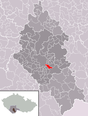
| Location of Srubec in the České Budějovice district | ||||

|
||||
Srubec , until 1924 Strubec (German Strups ) is a municipality in the Czech Republic . It is located six kilometers south-east of the city center of Budweis in South Bohemia and belongs to the Okres České Budějovice .
geography
Srubec is located in the Lišovský práh ( Lišovský práh ). The village is situated above the valleys of the rivers Dobrovodská stoka and Hodějovický creek on the hill Srubecký kopec ( Silver Mountain ). In the north lies the České Švýcarsko pond. The Na Pazderně (552 m) rises to the east, the Chlumek (536 m) and the Hůrecký kopec (541.7 m) to the south and the Větrná (493 m) to the west. Road II / 157 leads through Srubec from České Budějovice to Ledenice .
Neighboring towns are Dobrá Voda u Českých Budějovic , Na Chalupách, České Švýcary, Nové Třebotovice and Malé Dubičné in the north, Třebotovice in the north-east, U Votavů and Ohrazení in the east, U Čápa, Ohrazeníčko, U Šoupnýtila in the south-east, Naborátila and Hůrka in the south, Doubravice in the south-west, Staré Hodějovice and Nové Hodějovice in the west and U Veselských, Stará Pohůrka and Na Škardě in the north-west.
history
The village was probably formed at the transition from the 14th to the 15th century. The first written mention of the place took place in 1439 as the property of the Budweiser merchant Andreas Sowa ( Ondřej Sova ). He pledged the village, consisting of 24 subordinate properties, to Peter Vlasák. Sowa later released the pledge and acquired the Strubec ( Sova ze Strubce ) rating . His daughter and heiress Dorothea ( Dorota ) transferred the property to her husband Johann Puklitz von Wstuch ( Jan Puklice ze Vstuh ) in 1478 , who died in autumn 1482 and left the property to his older brother Wenzel. Since Wenzel Puklitz von Wstuch had no descendants, in 1494 he appointed his niece Johanna as heiress of Strubec in his will. In 1500 she left the estate to her husband Leonhard Eckhard von Urtinowitz ( Linhart Ekhart z Urtvinovic ). After the Eckhard von Urtinowitz family briefly pledged the estate to the Vladiken Bejšovec von Bejšov in 1522 , they later sold it to the Budweiser Nikolaus Straboch ( Mikuláš Štraboch ), who sold it to the city of Budweis before 1539. Johanna's son Johann Eckhard von Urtinowitz protested against this purchase in 1540 and was able to successfully enforce his claims to the property against the city. At that time , abundant silver ore deposits were discovered on the Strubecer Berg, later called Silberberg . In 1541 the Pauli Conversion ( Obrácení svatého Pavla ) and Old Bock ( U starého kozla ) silver mines were opened. In 1548 four mines were added with the poor council ( Chudá rada ), grandfather ( Na Pradědu ), wild man ( Divoký muž ) and the Divine Assistance ( Boží pomoc ) and in 1565 three more. In 1557 Johann's son Abraham Eckhard von Urtinowitz inherited the estate, followed by his brother Jakob. He sold Strubec in 1565 to Mikuláš Humpolec von Tuchoraz, an official in the service of Wilhelm von Rosenberg . Mikuláš's daughter Katharina and her husband Friedrich Schefflinger von Rirsdorff occasionally used the predicate of Strubetz ( z Strubce ). In 1600 Katharina sold the estate to Melchior Kolichrayther von Kolichreit , who sold it to the city of Budweis in 1602 for 5000 shock Meissnian groschen. Silver mining, which had come to a standstill due to the Thirty Years' War, was resumed at the end of the 18th century. In 1817 the St. Johannes Nepomuk ( Svatý Jan Nepomucký ) coal mine went into operation. In 1840 Strups / Strubec consisted of 43 houses with 210 inhabitants. The village included four scattered Dominical houses to the east, which had been built on the grounds of the emphyteutized Strups Meierhof, as well as a rustic sloop located there. The parish was Gutwasser . Until the middle of the 19th century the village was always subject to the city of Budweis.
After the abolition of patrimonial Strubec / Strups formed from 1850 with the district České Ohrazení / Böhmisch Baumgarten a municipality in the district administration Budějovice / Budweis. The Strups silver mines were finally closed in 1852. In 1903 Josef Lenc founded a tree nursery in Strups, which in 1908 became the property of Vojtěch Bendík. In 1910 the community had 715 Czech-speaking residents. 530 people lived in the Strubec district and 185 in České Ohrazení . Between 1910 and 1914 attempts were made to resume silver mining. In 1920 České Ohrazení broke up and formed its own municipality. In 1922 a public library was created. On September 1, 1923, the primary school started teaching. In 1924 the official Czech place name was changed to Srubec . In 1929 Srubec was electrified. The local branch of the Sokol gymnastics club was established in 1937. During the German occupation between 1941 and 1943, all clubs in the town, with the exception of the fire department, were dissolved. In 1954, the regular bus service to České Budějovice was taken up, but this was stopped after four months of operation and resumed in November 1956. After discussions had been held since 1960 about dividing the České Budějovice district of Pohůrka into an urban and rural part, this was carried out in 1963. The border was the intersection of Ledenice Street with the new road from Mladé to Dobrá Voda. So Nová Pohůrka remained at České Budějovice and formed the district Pohůrka, while the old village Pohůrka was renamed to Srubec under the name Stará Pohůrka . A local water supply was built between 1988 and 1993. Since October 8, 2003, the community has had a coat of arms and a banner. Today Srubec is connected to the public transport of the city of České Budějovice.
Community structure
The municipality of Srubec consists of the districts Stará Pohůrka ( Bucharten ) and Srubec ( Strups ), the settlement Na Štětkách and the layers of České Švýcary, Na Škardě, U Šoupných and U Veselských. Basic settlement units are Na Škardě, Na Štětkách, Srubec and Stará Pohůrka.
Attractions
- Chapel of the Virgin Mary on the village square of Srubec, built in 1908. After its renovation, it was consecrated in 2002.
- Chapel in the Stará Pohůrka village square
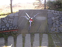
- Memorial stone for the Canadian pilot Robert W. Whitehead who was shot down on April 11, 1945, unveiled on October 28, 1945
- Memorial for the fallen of the First World War, created in 1919 by the sculptor Erwin Schopenhauer from Gutwasser
- Source České Švýcarsko, north of the village in the valley of Dobrovodská stoka
- Farmsteads in the South Bohemian peasant baroque style
Web links
Individual evidence
- ↑ http://www.uir.cz/obec/545066/Srubec
- ↑ Český statistický úřad - The population of the Czech municipalities as of January 1, 2019 (PDF; 0.8 MiB)
- ^ Johann Gottfried Sommer : The Kingdom of Bohemia; Represented statistically and topographically. Ninth volume. Budweiser district. JG Calve'sche Buchhandlung, Prague 1841, p. 28 ( limited preview in the Google book search).
- ↑ http://rodopisna-revue-online.tode.cz/jihogen/srubec.jpg
- ↑ http://rodopisna-revue-online.tode.cz/jihogen/s.htm#srubec
- ↑ http://www.uir.cz/casti-obce-obec/545066/Obec-Srubec
- ↑ http://www.uir.cz/zsj-obec/545066/Obec-Srubec


