Kamenný Újezd
| Kamenný Újezd | ||||
|---|---|---|---|---|
|
||||
| Basic data | ||||
| State : |
|
|||
| Region : | Jihočeský kraj | |||
| District : | České Budějovice | |||
| Area : | 2897 ha | |||
| Geographic location : | 48 ° 54 ' N , 14 ° 27' E | |||
| Height: | 493 m nm | |||
| Residents : | 2,393 (Jan 1, 2019) | |||
| Postal code : | 373 81 | |||
| License plate : | C. | |||
| traffic | ||||
| Street: | Ceske Budejovice - Velešín | |||
| Railway connection: | Linz Hbf – České Budějovice | |||
| Next international airport : | České Budějovice Airport | |||
| structure | ||||
| Status: | local community | |||
| Districts: | 9 | |||
| administration | ||||
| Mayor : | Jitka Šebelková (as of 2018) | |||
| Address: | Náměstí 220 373 81 Kamenný Újezd |
|||
| Municipality number: | 544663 | |||
| Website : | www.kamenny-ujezd.cz | |||
| Location of Kamenný Újezd in the České Budějovice district | ||||

|
||||
Kamenný Újezd (German stone churches ) is a municipality in the Czech Republic . It is nine kilometers south of the city center of Budweis (České Budějovice) on the Summerauerbahn on a plateau between the Vltava and Maltsch valleys .
history
The place was probably the seat of the knights de Wgezt ( Ujezd ), who were settled between Moldau and March at the beginning of the 13th century. The place was first documented in 1263, when Wernherus de Steynchirchen was mentioned as a witness at the foundation of the Goldenkron monastery . In the same year Michael de Wgezt also appeared as a seller of the place Záhoří to the Hohenfurth monastery .
Steinkirchen was created at the intersection of an old trade route between Bohemia and Austria with a ford route through the Maltsch and the Moldau. An elongated village green, the church and an adjacent fortress formed the center of the village. In the middle of the 14th century, the old fortress in the village no longer met the demands of the de Wgezt, and they built the Maškovec castle west of the village in the rocks above the Vltava, which became their seat. The rulership was split up through inheritance divisions, which came into the possession of the Rosenbergs in 1455 . In the 15th century, the neighboring towns of Češnovice and Libský completely merged with Újezd. A brisk commercial life developed in Steinkirchen and it enjoyed the privileges of a noble media town. The place had 5 malt houses , 24 taverns and licensed houses as well as at least 5 inns. In 1464 it lost this unfounded status after disputes with the city of Budweis and fell under the city's ban mile . The Rosenbergs ignored this and continued to facilitate the settlement of various trades; the Steinkirchen beer was secretly introduced to Budweis and sold in the cityscape. In 1552 Steinkirchen finally received city rights.
To bypass the ban mile, Jakob Krčín von Jelčany received the concession in 1564 to build a brewery in Plavnice to the south-east, whose beer was now sold in Steinkirchen. In 1579 a mill with a pond was built in Plavnice.
Because of over-indebtedness, the last Rosenberg, Peter Wok, had to sell the Krumau rule , which also included Steinkirchen, to Emperor Rudolf II in 1602 . The Thirty Years War brought the city into decline and the city charter expired. The trade route to Austria was now used for the passage of troops, Steinkirchen was sacked and over half of the buildings fell in desolation. In 1622 Hans Ulrich von Eggenberg became the new landlord, after the family died out, the property passed to the Schwarzenbergs in 1719 .
With the replacement of the manorial power in Bohemia, Steinkirchen formed an independent municipality since 1849. In 1913 there were 1,507 inhabitants in the municipality of Steinkirchen, 1,499 of them Czechs and 7 Germans. The place Steinkirchen had 1,317 inhabitants, of which 1,312 were Czech and 4 German nationality, in Freiles of the 190 inhabitants 187 were Czechs and 3 Germans.
On November 1st, 1975 the places Březí, Bukovec, Radostice, Rančice, Opalice, Kosov, Krasejovka and Milíkovice were incorporated into Kamenný Újezd.
Lake Štilec is located southwest of the village of Kamenný Újezd, and there is a car campsite on it from May to September.
Community structure
The municipality of Kamenný Újezd consists of the following districts:
- Březí ( Freiles )
- Bukovec
- Kamenný Újezd
- Kosov ( Kossau )
- Krasejovka ( Krassau )
- Milíkovice ( Millikowitz )
- Opalice ( Oppalitz )
- Radostice ( Radostitz ) and
- Rančice ( Rantschitz )
Kamenný Újezd also includes Adam, Bartochov, Bednářství, Borek ( Bourek ), Hevel, Houška, Hvízdalka, Mašek, Na Dolech, Otmanka ( Ottmanka ), Ovčín, Plavnice, Strnad, U Burdurm ( Burda ), U Kotka and V . Basic settlement units are Březí, Bukovec, Kamenný Újezd, Kosov, Krasejovka, Milíkovice, Na Dolech, Opalice, Otmanka, Plavnice, Radostice and Rančice.
The municipality is divided into the cadastral districts of Kamenný Újezd, Kosov u Opalic, Krasejovka, Opalice and Otmanka.
coat of arms
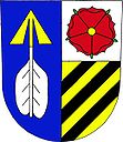
Description : Blue with a golden arrow , the point upwards, and silver plumage is split in silver with a red rose with a golden lug split in gold with three black oblique bars .
Partner municipality
- Krauchthal , Switzerland
Attractions
- The parish church of All Saints already existed as a stone building in 1263; from her the German name Steinkirchen is derived . There have been written records of patronage since 1383. The sacristy and presbytery were built around 1500 in the Gothic style. The bells, altars and statues date from the 16th and 17th centuries. The tower was built from 1690 and at the beginning of the 18th century the church was given its baroque appearance. Restoration work took place in 1995 and 1999.
- The rectory next to the church can be traced back to 1290.
- The column of St. John of Nepomuk in Plavnice was restored in 2005
Sons and daughters of the church
- Václav Reischl (* 1947), Czech photographer and documentary filmmaker
Web links
Individual evidence
- ↑ http://www.uir.cz/obec/544663/Kamenny-Ujezd
- ↑ Český statistický úřad - The population of the Czech municipalities as of January 1, 2019 (PDF; 0.8 MiB)
- ↑ http://www.uir.cz/casti-obce-obec/544663/Obec-Kamenny-Ujezd
- ↑ http://www.uir.cz/zsj-obec/544663/Obec-Kamenny-Ujezd
- ↑ http://www.uir.cz/katastralni-uzemi-obec/544663/Obec-Kamenny-Ujezd


