Dubné
| Dubné | ||||
|---|---|---|---|---|
|
||||
| Basic data | ||||
| State : |
|
|||
| Region : | Jihočeský kraj | |||
| District : | České Budějovice | |||
| Area : | 1677 ha | |||
| Geographic location : | 48 ° 59 ' N , 14 ° 22' E | |||
| Height: | 410 m nm | |||
| Residents : | 1,577 (Jan 1, 2019) | |||
| Postal code : | 373 84 | |||
| License plate : | C. | |||
| traffic | ||||
| Street: | České Budějovice - Lhenice | |||
| Next international airport : | České Budějovice Airport | |||
| structure | ||||
| Status: | local community | |||
| Districts: | 4th | |||
| administration | ||||
| Mayor : | Božena Kudláčková (as of 2018) | |||
| Address: | Dubné 60 373 84 Dubné |
|||
| Municipality number: | 544442 | |||
| Website : | www.dubne.cz | |||
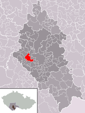
| Location of Dubné in the České Budějovice district | ||||

|
||||
Dubné (German Duben ) is a municipality in the Czech Republic . It is located eight kilometers west of České Budějovice in South Bohemia and belongs to the Okres České Budějovice .
geography
Dubné is located north of the Blanský les in the Budweiser Basin ( Českobudějovická pánev ). There are numerous ponds in the vicinity of the village; the largest are the Nuzov, Vitín and Dubeňák northeast of Dubné. In the west rises the Vráže ( Wraz , 480 m nm).
Neighboring towns are Křenovice in the north, Jednoty and Hluchá Basta in the Northeast, Branišov and Mokré the east, Třebín, Na Hradišti, U Hradišťáků and Kaliště u Lipí the southeast, Lipí and Habří in the south, Kvítkovice in the southwest, Pláně, Čakovec Čakov in the West and Holubovská Bašta and Žabovřesky in the northwest.
history
The first written mention of Dubné took place in 1263 as the seat of the Vladikem Zvzlab de Dvdem ( Sudslav z Dubného ). The Church of the Assumption is documented since 1390. Duben was a common good. After the battle of the White Mountain , the property belonging to Adam Chwal Kunasch von Machowitz was confiscated for participating in the uprising of 1618 and sold to the royal city of Budweis in 1623 . The first single-class village school was established in 1659.
In 1840 Duben or Dubny consisted of 31 houses with 218 inhabitants. The parish church of the Assumption of Mary, the parish and the school were under the patronage of the authorities. To the west were two Dominikal houses and a rustic chalet on emphyteutized meierhof grounds. Duben was the parish for Třebin (Třebín), Branischen , Křenowitz (Křenovice), Jaronitz (Jaronice), Habřj , Slavtsch (Slavče), Zabowřesk , Lipen , Hratzen and Kwitkowitz . And two each to the dominions Frauenberg and Krumau . Until the middle of the 19th century the village was always subject to the city of Budweis.
After the abolition of patrimonial Dubné / Duben formed a community in the judicial district of Budweis from 1849 . From 1868 the municipality belonged to the Budweis district . In 1888 a new school building for four-class classes was completed. On March 25, 1943 Branišov , Křenovice and Třebín were incorporated, this was repealed in 1945 after the end of the Second World War. In 1949 the community was assigned to the Okres České Budějovice-okolí. In the course of the territorial reform Branišov, Jaronice, Křenovice and Třebín were incorporated on June 12, 1960. On September 1, 1963, a new nine-grade elementary school was inaugurated. The old school house was redesigned as a community office and community hall. After a referendum, the Branišov district broke away from Dubné at the beginning of 1994.
Community structure
The municipality Dubné consists of the districts Dubné ( Duben ), Jaronice ( Jaronitz ), Křenovice ( Kschenowitz ) and Třebín ( Trebin ), which also form cadastral districts. Dubné also includes the Jednoty ( Four Thieves ) gang as well as the layers Na Hradišti, Pláně, U Hradišťáků, U Matoušů and U Šindelářů. Basic settlement units are Dubné, Jaronice, Křenovice, Třebín and U Dubného.
Attractions
- Church of the Assumption
- Rectory, with remains of walls from the Dubné fortress
- several folk style farms
- Memorial stone for the fallen of World War I on the village square, unveiled in 1922
- prehistoric barrows in the Kotlová forest
Web links
Individual evidence
- ↑ http://www.uir.cz/obec/544442/Dubne
- ↑ Český statistický úřad - The population of the Czech municipalities as of January 1, 2019 (PDF; 0.8 MiB)
- ↑ Johann Gottfried Sommer The Kingdom of Bohemia, Vol. 9 Budweiser Kreis, 1840, p. 28
- ↑ http://www.uir.cz/casti-obce-obec/544442/Obec-Dubne
- ↑ http://www.uir.cz/katastralni-uzemi-obec/544442/Obec-Dubne
- ↑ http://www.uir.cz/zsj-obec/544442/Obec-Dubne


