
Hosin
| Hosin | |||||
|---|---|---|---|---|---|
|
|||||
| Basic data | |||||
| State : |
|
||||
| Region : | Jihočeský kraj | ||||
| District : | České Budějovice | ||||
| Area : | 3097 ha | ||||
| Geographic location : | 49 ° 2 ' N , 14 ° 29' E | ||||
| Height: | 486 m nm | ||||
| Residents : | 879 (Jan 1, 2019) | ||||
| Postal code : | 373 41 | ||||
| License plate : | C. | ||||
| traffic | |||||
| Street: | Borek - Hluboká nad Vltavou | ||||
| Railway connection: | České Budějovice – Veselí nad Lužnicí | ||||
| Next international airport : | České Budějovice Airport | ||||
| structure | |||||
| Status: | local community | ||||
| Districts: | 2 | ||||
| administration | |||||
| Mayor : | Jan Řičánek (as of 2018) | ||||
| Address: | Hosín 116 373 41 Hluboká nad Vltavou |
||||
| Municipality number: | 544523 | ||||
| Website : | www.hosin.cz | ||||
| Location of Hosín in the České Budějovice district | |||||

|
|||||


Hosín (German Hosin , formerly Hosyn ) is a municipality in the Czech Republic . It is located seven kilometers north of České Budějovice in South Bohemia and belongs to the Okres České Budějovice . The landmark of the place is the three-tower church of St. Peter and Paul, towering over the Vltava valley at the highest point of the village.
geography
Hosín is located on the right-hand side above the Vltava valley at the slope of the Lischau threshold to the Budweiser Basin. The village extends on the southern slope of the Račice (508 m) on both sides of the valley of the Hosínský potok, which flows into the Opatovická stoka to the west. The Jalovcový vrch (454 m) rises to the east. The town is bypassed to the west and north by the České Budějovice – Veselí nad Lužnicí railway line ; the Hluboká nad Vltavou-Zámostí station and the Hosín stop are in the vicinity of Hosin. To the east of the village, the České Budějovice Aeroclub operates the Hosín airfield.
Neighboring towns are Nová Obora and Dobřejovice in the north, Chotýčany and Lhotice in the Northeast, Chyňava, Jednota and Červený Újezdec in the east, Jelmno, Libníč and Borek in the southeast, Hrdějovice and Trögrův Dvůr in the South, Bavorovice in the southwest, Opatovice, Ohrada and Vondrov in the West as well as Podskalí, Hluboká nad Vltavou and Zámostí in the northwest.
history

Evidence of an early settlement is provided by several Bronze Age barrows from the time of the Slavic castle hill culture in the vicinity of the place. Structural studies of the oldest part of the church showed that it was built between 1050 and 1200 and in the 13th century by a new larger building in the Gothic style had been replaced.
In 1262 the Hosyn forest was first mentioned in a document . The first written evidence of the village of Hossing and the church belonging to Froburg was made in 1330 in connection with the pleban Ulrich. Hosín formed the spiritual center for the villages in the heights east of the Vltava and was always subject to the Frauenburg, which maintained a stately court here. King Vladislav II Jagiello granted the overseer Jiřík special privileges in 1489 and, in return for overseeing the sovereign forests, exempted him from paying taxes to the women's castle and the church of Hosyn . The registers have been kept since 1599. In 1684 the rulers appointed a chaplain in Hosyn to support the pastor. In 1699, the Schwarzenberg Hosyn Hunting Association was the first hunting association in the Kingdom of Bohemia. After financial speculation and participation in the class uprising of 1618, the goods of the Malovec of Malovice were confiscated and in 1623 the rule was transferred to Baltasar of Marradas , who had them recatholized.
The owners included the Bohemian Crown, the lords of Lobkowicz , von Pernstein , von Neuhaus , Malovec von Malovice, von Marradas and finally from 1661 the princes Schwarzenberg .
In the course of the Josephine reforms in 1781, the old cemetery at the church was closed and moved outside the village. On the occasion of a visit to Prince Johann Joseph zu Schwarzenberg , the Russian Tsar Alexander I paid a visit to the Hosyn farm on October 19, 1815 . On the way to Frauenberg, the tsar saw the cottage trader Lorenz Vajtl working in the fields in a potato field in the Dobřejovice forest. The Tsar asked to take over the plow, dug a furrow and thanked Vajtl with six Louisdors . In 1840 Hosin / Hosyn consisted of 39 houses with 350 inhabitants. In the village there was a parish church, rectory, school and an inn. Hosin was vicarage for Dobřegitz ( Dobřejovice ) Schmiedtberger trench , Lhotitz ( Lhotice ) Hartowitz and Opatowitz ( Opatovice ) as well as several to Zamost ( Zámostí associated) monolayer . In 1854 the whole village burned down. Until the middle of the 19th century, the village was always subject to the Frauenberg rule.

After the abolition of patrimonial formed Hosin / HOSYN 1850 with the hamlet Bida a municipality in the district of Budweis . The Koh-i-Noor Hardtmuth company had been operating kaolin tunnels in Orty since the 1870s . In 1910 there were 681 Czech-speaking residents in the community, while the district of Hosín had 522 residents. After the Munich Agreement in 1938, Czech refugees from the Sudetenland settled in the community ; At the end of the Second World War, the place also served numerous Budweiser families as a refuge from the Allied bombings. On May 16, 1954, Borek was separated and formed its own community. The newly created Borek cadastre was also formed from parts of the Hrdějovice and Úsilné corridors. On June 14, 1964 the incorporation of Dobřejovice took place. The sports airfield, which was laid out in 1957, hosted the world championships in aerobatics in 1978.
Community structure
The municipality Hosín consists of the districts Dobřejovice ( Dobschejowitz ) and Hosín ( Hosin ), which also form cadastral districts. The residential areas Chyňava ( Chiniawa ), Jednota, Nová Obora and Těšín also belong to Hosín .
Attractions
- Neo-Romanesque parish church of St. Peter and Paul, built 1898–1900 in place of a Romanesque church from the 12th century, which was preserved as a side chapel. The Gothic wall paintings preserved in it were restored in 1901.
- Baroque rectory from the 18th century
- Wayside shrine with the coat of arms of Baltasar of Marradas from 1636
- Orty natural monument, system of kaolin tunnels on the border with Borek and Hrdějovice, it is considered a bat retreat
- Gabled courtyards in the South Bohemian peasant baroque
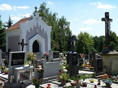
graveyard

St. Peter and Paul

Homestead No. 42


Web links
Individual evidence
- ↑ http://www.uir.cz/obec/544523/Hosin
- ↑ Český statistický úřad - The population of the Czech municipalities as of January 1, 2019 (PDF; 0.8 MiB)
- ↑ Johann Gottfried Sommer The Kingdom of Bohemia, Vol. 9 Budweiser Kreis, 1840, p. 44
- ↑ Archive link ( Memento of the original from August 18, 2007 in the Internet Archive ) Info: The archive link was inserted automatically and not yet checked. Please check the original and archive link according to the instructions and then remove this notice.
- ↑ http://www.uir.cz/casti-obce-obec/544523/Obec-Hosin
- ↑ http://www.uir.cz/katastralni-uzemi-obec/544523/Obec-Hosin