Dříteň
| Dříteň | ||||
|---|---|---|---|---|
|
||||
| Basic data | ||||
| State : |
|
|||
| Region : | Jihočeský kraj | |||
| District : | České Budějovice | |||
| Area : | 4608 ha | |||
| Geographic location : | 49 ° 9 ' N , 14 ° 21' E | |||
| Height: | 450 m nm | |||
| Residents : | 1,687 (Jan 1, 2019) | |||
| Postal code : | 373 48 - 373 51 | |||
| License plate : | C. | |||
| traffic | ||||
| Street: | Netolice - Týn nad Vltavou | |||
| structure | ||||
| Status: | local community | |||
| Districts: | 10 | |||
| administration | ||||
| Mayor : | Josef Kudrle (as of 2018) | |||
| Address: | Dříteň 152 373 51 Dříteň |
|||
| Municipality number: | 544426 | |||
| Website : | www.obecdriten.cz | |||
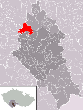
| Location of Dříteň in the České Budějovice district | ||||

|
||||
Dříteň (German Zirnau ) is a municipality in the Czech Republic . It is located 21 kilometers northwest of České Budějovice and belongs to the Okres České Budějovice .
history
The first documentary mention of Dříteň comes from 1432. Until the abolition of patrimonial rule in 1850, the place belonged to the Hluboká nad Vltavou manor . During the Thirty Years' War the Battle of Sablat took place on June 10, 1619 between Záblatí and Záblatíčko . Under Johann Adolf von Schwarzenberg, Antonio de Maggi converted the fortress into a castle between 1669 and 1674 . In 1691 the Church of St. Dismas was built, which is a branch church of Bílá Hůrka. From 1850 the municipality was part of the Budweis district .
coat of arms
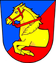
Description : Divided in blue and red diagonally to the left and a red bridled, jumping horse's front in gold, which is borrowed from the coat of arms of the Lords of Malowetz .
Community structure
The municipality consists of the districts Dříteň ( Zirnau ) Chvalešovice ( Chwalschowitz ) Libív ( libiw ) Malešice ( Maleschitz ) Radomilice ( Radomilitz ) Strachovice ( Strachowitz ) Velice ( Welitz ) Záblatí ( Großsablat ) and, Záblatíčko ( Kleinsablat ) and the settlements of Bílá Hůrka ( Weißhurka ), Na Překážce, Ovčín and Pazderna ( Pazderny ). Basic settlement units are Bílá Hůrka, Dříteň, Chvalešovice, Libív, Malešice, Pazderna, Radomilice, Strachovice, Velice, Záblatí and Záblatíčko.
The municipality is divided into the cadastral districts Dříteň, Chvalešovice and Záblatí.
Attractions
- Dříteň Castle
- Branch church of St. Dismas in Dříteň
- Marterl columns in Strachovice, Radomilice and Záblatíčko
- Statue of St. John of Nepomuk in Dříteň
- Chapels of St. Anne and St. Wenceslas in Bílá Hůrka
- Chapels in the village squares of Velice, Malešice, Dříteň, Záblatí, Chvalešovice and Strachovice
- Farmhouses in the South Bohemian peasant baroque
- Cross on the battlefield from 1619
Sons and daughters of the church
- Rudolf Dvořák (1860–1920), orientalist
Web links
Individual evidence
- ↑ http://www.uir.cz/obec/544426/Driten
- ↑ Český statistický úřad - The population of the Czech municipalities as of January 1, 2019 (PDF; 0.8 MiB)
- ↑ http://www.uir.cz/casti-obce-obec/544426/Obec-Driten
- ↑ http://www.uir.cz/zsj-obec/544426/Obec-Driten
- ↑ http://www.uir.cz/katastralni-uzemi-obec/544426/Obec-Driten

