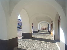
Netolice
| Netolice | ||||
|---|---|---|---|---|
|
||||
| Basic data | ||||
| State : |
|
|||
| Region : | Jihočeský kraj | |||
| District : | Prachatice | |||
| Area : | 2635 ha | |||
| Geographic location : | 49 ° 3 ' N , 14 ° 12' E | |||
| Height: | 432 m nm | |||
| Residents : | 2,587 (Jan 1, 2019) | |||
| Postal code : | 384 11 | |||
| License plate : | C. | |||
| traffic | ||||
| Street: | Ceske Budejovice - Vimperk | |||
| Railway connection: | Dívčice – Netolice | |||
| structure | ||||
| Status: | city | |||
| Districts: | 2 | |||
| administration | ||||
| Mayor : | Vladimír Pešek (as of 2018) | |||
| Address: | Mírové Náměstí 208 384 11 Netolice |
|||
| Municipality number: | 550442 | |||
| Website : | www.netolice.cz | |||
| Location of Netolice in the Prachatice district | ||||

|
||||
Netolice (German Nettolitz , also Netolitz ) is a city in the Czech Republic . It is located 23 kilometers northwest of the center of Budweis and belongs to the Okres Prachatice .
geography
location
Netolice is located in the northern foothills of the Blanský les on the Bezdrevský potok , known as the Nettolitzer hill country , which is also called Netolický potok here. There are several larger ponds to the south and west of the city. Netolice is the intersection of the state roads 145 between Budweis and Vimperk with the 122 between Smědeč and Týn nad Vltavou and the starting point of the 142 to Volyně .
Neighboring towns are Krtely and Hradiště in the north, Hláska and Podeřiště in the Northeast, Mahouš and Olšovice the east, Hlodačky and Babice in the southeast, Lužice and Grejnarov in the south, Peklo, Podroužek, Švarcenberk and Hrbov in the southwest, Petrův Dvůr and Kratochvíle in the west and Velký Boron in the northwest.
Neighboring communities
| Strunkovice | Malovice | Olšovice |
| Hracholusky |

|
Mahouš |
| Lhenice | Lužice , Babice |
history
According to the Chronica Boemorum , Netolice is said to have been one of the frontier forts of Prince Slavník in 981 . After the Slavnikids were destroyed by the Přemyslids , they took over the castle, which went down in the 13th century.
Below the castle was the outer bailey with the church of St. Wenceslas, the existence of which has been considered secure since 1167 and around which a town was built. An earlier document about this, dated 1088, was probably also created at this time. 1253 is found in a document of Ottokar II Přemysl the last mention of a castellan from Netolice. After the establishment of the Goldenkron monastery in 1263 by Ottokar II, the latter left Netolice to the monastery. In 1284 the Church of the Assumption of Mary was consecrated.
From the founding of the city up to the 14th century, Netolice had a predominantly German population, whose share later fell to an insignificant minority. Netolice was located on the Goldener Steig and gained importance in the Middle Ages through the cattle markets.
After the destruction of the Goldenkron monastery by the Hussites , Ulrich II von Rosenberg appropriated its possessions. After Peter Wok von Rosenberg had to sell Netolice to Rudolf II in 1601 due to excessive indebtedness , Ferdinand II left the city to his favorite Hans Ulrich von Eggenberg in 1621 . After the victory in the Battle of Sablat , the imperial troops under Heinrich von Dampierre burned the city down in 1619.
After the Eggenbergs died out , Netolice passed to the Schwarzenbergs in 1719 . In the 18th century the horse markets gave Netolice importance. The rural area, which was made up of only a few houses, became a center for horse breeding.
After patrimonial was replaced, Netolice became an independent town in 1848. The city was the seat of a district court and in 1930 had 2272 inhabitants.
Community structure
The town of Netolice consists of the districts Netolice (Nettolitz) and Petrův Dvůr (Peterhof) and the localities Kratochvíle ( Kurzweil ), Grejnarov ( Greinerhof ), Podroužek, Švarcenberk ( Schwarzenberg ) and Peklo. Basic settlement units are Kratochvíle, Netolice, Petrův Dvůr and Podroužský mlýn.
Partner municipality
- Ringelai , Germany - since 2010
Culture and sights
Museums
- Muzeum JUDr. Otakara Kudrny, Mírové náměstí 248
Buildings
- Archeopark Netolice on Janský vrch, excavation site of the castle stables from the 10th-13th centuries century
- St. Wenceslas Church, built in the 13th century in place of a previous Romanesque building and redesigned in Baroque style in the 18th century
- Church of the Assumption of Mary, built in 1284, after a reconstruction in 1625 it received its baroque appearance in 1770
- Kratochvíle Castle , two kilometers northwest of the city on the Kratochvílský rybník, was built between 1583 and 1589 in the corridors of the desolate Rohn monastery for Wilhelm von Rosenberg .
- Group of statues of St. John of Nepomuk in the market
- Town hall, neo-renaissance building, built in 1869 with Josef Niklas
- Rosenberg houses on the market, in the Renaissance buildings there is the Otakar Kudrna Museum.
- Building of the former town brewery in Petrův Dvůr, founded in 1663 and rebuilt in the second half of the 19th century
- Market fountain, created in 1677 by the sculptor Jiří Plánský
- Krčín Canal, the eight kilometer long canal built in the 16th century by Jakob Krčín von Jelčany , carries water from the Melhutka brook from Hrbova over several ponds to the fountains in the Kratochvíle chateau park
sons and daughters of the town
- Franz Andreas Holly (1747–1783), composer
Web links
- Archeopark
- History (czech)


