Bušanovice
| Bušanovice | ||||
|---|---|---|---|---|
|
||||
| Basic data | ||||
| State : |
|
|||
| Region : | Jihočeský kraj | |||
| District : | Prachatice | |||
| Area : | 973 ha | |||
| Geographic location : | 49 ° 7 ' N , 13 ° 57' E | |||
| Height: | 540 m nm | |||
| Residents : | 265 (Jan. 1, 2019) | |||
| Postal code : | 384 22 | |||
| License plate : | C. | |||
| traffic | ||||
| Street: | Předslavice - Vlachovo Březí | |||
| Next international airport : | České Budějovice Airport | |||
| structure | ||||
| Status: | local community | |||
| Districts: | 1 | |||
| administration | ||||
| Mayor : | Miroslav Beránek (as of 2018) | |||
| Address: | Bušanovice 47 384 22 Vlachovo Březí |
|||
| Municipality number: | 550159 | |||
| Website : | www.busanovice.cz | |||
| Location of Bušanovice in the Prachatice district | ||||

|
||||
Bušanovice (German Buschanowitz ) is a municipality in the Czech Republic . It is located 12 kilometers northwest of Prachatice and belongs to the Okres Prachatice .
geography
location
Bušanovice is located in the valley basin of the Bušanovický potok in the hilly landscape of the Bohemian Forest foreland .
Neighboring towns are Předslavice in the north, Všechlapy and Bohunice in the northeast, Tvrzice and Ovčín in the east, Újezdec in the southeast, Dolní Nakvasovice in the south, Beneda in the southwest, Želibořice in the west and Úlehle in the northwest.
Community structure
The municipality Bušanovice consists of the districts Beneda, Bušanovice (Buschanowitz) , Dolní Nakvasovice (Lower Nakvasowitz) , Horní Nakvasovice (Upper Nakwasowitz) and Želibořice (Scheliborschitz) . Basic settlement units are Beneda, Bušanovice, Dolní Nakvasovice and Horní Nakvasovice.
The municipality is divided into the cadastral districts of Bušanovice, Dolní Nakvasovice and Horní Nakvasovice.
Neighboring communities
| Předslavice | Tvrzice | |
| Zálezly |

|
Újezdec |
| Vlachovo Březí |
history
Bušanovice was first mentioned in a document in 1315. Until the middle of the 19th century, the village belonged to the Vlachovo Březí domain .
After the abolition of patrimonial Bušanovice formed from 1850 a district of the municipality Předslavice in the Strakonice district . In 1880 Bušanovice consisted of 56 houses and had 308 inhabitants. In 1900 the place became an independent municipality, which was reclassified in 1950 to Okres Prachatice. On July 1, 1985 it was incorporated into Vlachovo Březí; since November 24, 1990 the municipality Bušanovice exists again.
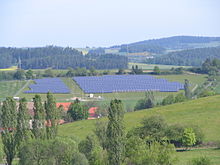
On January 29, 2007, near Bušanovice, the largest solar power plant in the Czech Republic, operated by Korowatt sro and until the plant in Ostrožská Lhota (1500 kW) went into operation, started operations. The photovoltaic system has a maximum output of 600 kW.
Attractions
- Memory of the earlier Želibořice fortresses, which can be verified as the seat of Vladiken Bohuslaus miles de Zeliboricz since 1329 ,
- Chapels in Beneda, Bušanovice, Dolní and Horní Nakvasovice and Želibořice
- Courtyards created by master mason Jakub Bursa in the Bohemian peasant baroque
Web links
Individual evidence
- ↑ http://www.uir.cz/obec/550159/Busanovice
- ↑ Český statistický úřad - The population of the Czech municipalities as of January 1, 2019 (PDF; 0.8 MiB)
- ↑ http://www.uir.cz/casti-obce-obec/550159/Obec-Busanovice
- ↑ http://www.uir.cz/zsj-obec/550159/Obec-Busanovice
- ↑ http://www.uir.cz/katastralni-uzemi-obec/550159/Obec-Busanovice


