
Kratušín
| Kratušín | |||||
|---|---|---|---|---|---|
|
|||||
| Basic data | |||||
| State : |
|
||||
| Region : | Jihočeský kraj | ||||
| District : | Prachatice | ||||
| Area : | 395 ha | ||||
| Geographic location : | 49 ° 1 ' N , 13 ° 54' E | ||||
| Height: | 613 m nm | ||||
| Residents : | 49 (Jan. 1, 2019) | ||||
| Postal code : | 384 21 | ||||
| License plate : | C. | ||||
| traffic | |||||
| Street: | Buk - Prachatice | ||||
| Next international airport : | České Budějovice Airport | ||||
| structure | |||||
| Status: | local community | ||||
| Districts: | 2 | ||||
| administration | |||||
| Mayor : | František Hodina (as of 2018) | ||||
| Address: | Kratušín 10 384 21 Husinec |
||||
| Municipality number: | 537136 | ||||
| Website : | www.kratusin.cz | ||||


Kratušín (German Kratusin , formerly Kratosin ) is a municipality in the Czech Republic . It is located five kilometers west of Prachatice in South Bohemia and belongs to the Okres Prachatice .
geography
Kratušín is located on the left side above the Blanice valley on a pass in the foreland of the Bohemian Forest . To the north rises the Stráž (701 m), east of the Dehetník (802 m), in the southeast of the Křepelický vrch (932 m), south of the Drslavický Kopec (679 m) and in the west of the Vrch (754 m).
Neighboring towns are Milešín and Lažiště in the north, Zábrdí and Oseky in the north-east, Zábrdský Mlýn, Podolí and Třemšín in the east, Křeplice and Stádla in the south-east, Horní Záblatí, Záblatí and Saladín in the south, Řepešín, Hamvr and Dýnšín in the south-east Mlýnšín, U Bartlůnšín Chlístov and Chválov in the west and Studená and Drslavice in the northwest.
history
Kratosin was first mentioned in writing in 1389 under the property of Hus Castle . After its destruction in 1441, the village became part of the Drslavice domain . In 1551 Wilhelm von Rosenberg , who had just been declared of legal age, bought the rule. His brother Peter Wok von Rosenberg sold the property to Wolf Nowohradsky von Kolowrat in 1603 . Hans Ulrich von Eggenberg united Drslavice with the Winterberg rule after 1630 . In the berní rula of 1654 ten farms are shown for the village. Johann Christian von Eggenberg bequeathed the goods to his wife Marie Ernestine von Schwarzenberg in 1710 , who left them to her brother Adam Franz Fürst von Schwarzenberg in 1719. He was followed in 1732 by his son Joseph Adam Prince von Schwarzenberg , from 1782 Johann I. Nepomuk Anton von Schwarzenberg and from 1789 Joseph II Prince von Schwarzenberg , whom his son Johann Adolf II Prince von Schwarzenberg inherited in 1833. In 1840 Kratosin / Kratusyn consisted of 16 houses with 132 Czech-speaking residents; this was also the highest number of inhabitants in the village. The parish was in Laschitz . Until the middle of the 19th century, the village was always subject to the allodial rule of Winterberg .
After the abolition of patrimonial Kratušín formed from 1850 a district of the municipality Zábrdí in the district administration Prachatice . In 1890 the village had grown to 26 houses. The Kratušín Volunteer Fire Brigade was formed in 1909, the one in Chlístov eight years earlier. In 1927 Kratušín broke away from Zábrdí and formed its own community. In 1930 the village had 109 inhabitants. As a result of the Munich Agreement , it had to be ceded to the German Reich in 1938. In 1939 there were 110 people living in Kratusin. Until the end of the Second World War, the village was part of the German district of Prachatitz . After the end of the Second World War, the community came back to Czechoslovakia. Chlístov was incorporated in 1949. In 1961 it was incorporated into Lažiště . After a referendum, Kratušín and Chlístov broke away from Lažiště on November 24, 1990 and formed their own community. Today only twelve houses are permanently inhabited in Kratušín, nine chalets are used as holiday homes.
Community structure
The municipality Kratušín consists of the districts Chlístov (Klistau) and Kratušín (Kratusin) , which also form cadastral districts. The residential areas Hamr, Na Šuferajnu and U Bartlů also belong to Kratušín.
Attractions
- Baroque chapel of St. Leonhard with a hexagonal floor plan and onion dome on the Kratušín village square, built in the 18th century
- Cross in front of the chapel of St. Leonhard, built in 1887
- large stone signpost next to the municipal office on the village square
- Chapel of St. Wenceslas in Chlístov
- Hus lime tree in Chlístov, the approximately 670-year-old mighty tree under which Jan Hus is said to have preached, is a listed building
- V polích natural monument , meadow with orchid population , northeast of the village
- Zábrdská skála natural monument , rocky slope on the Blanice, southeast of Kratušín, Uhubrutplatz
- Gold soaps on the Blanice, monument
- Attractions

Chapel in Kratušín
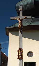
Cross in front of the chapel

Hus linden tree in Chlístov (photo by Jan Vilím, 1908)
.JPG)

.jpg)
Web links
Individual evidence
- ↑ http://www.uir.cz/obec/537136/Kratusin
- ↑ Český statistický úřad - The population of the Czech municipalities as of January 1, 2019 (PDF; 0.8 MiB)
- ↑ Johann Gottfried Sommer : The Kingdom of Bohemia, Bd. 8 Prachiner circle. 1840, p. 352
- ↑ Michael Rademacher: German administrative history from the unification of the empire in 1871 to the reunification in 1990. Prachatitz district (Czech. Prachatice). (Online material for the dissertation, Osnabrück 2006).
- ↑ http://www.uir.cz/casti-obce-obec/537136/Obec-Kratusin
- ↑ http://www.uir.cz/katastralni-uzemi-obec/537136/Obec-Kratusin