Vitějovice
| Vitějovice | ||||
|---|---|---|---|---|
|
||||
| Basic data | ||||
| State : |
|
|||
| Region : | Jihočeský kraj | |||
| District : | Prachatice | |||
| Area : | 1181 ha | |||
| Geographic location : | 49 ° 3 ' N , 14 ° 4' E | |||
| Height: | 509 m nm | |||
| Residents : | 517 (Jan. 1, 2019) | |||
| Postal code : | 384 27 | |||
| License plate : | C. | |||
| traffic | ||||
| Street: | Prachatice - Netolice | |||
| structure | ||||
| Status: | local community | |||
| Districts: | 1 | |||
| administration | ||||
| Mayor : | Lenka Tůmová (as of 2018) | |||
| Address: | Vitějovice 32 384 27 Vitějovice |
|||
| Municipality number: | 550655 | |||
| Website : | www.vitejovice.cz | |||
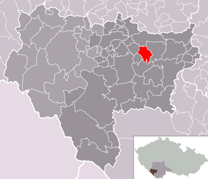
| Location of Vitějovice in the Prachatice district | ||||

|
||||
Vitějovice (German Witjejitz , formerly Witiegitz ) is a municipality in the Czech Republic . It is located seven kilometers northeast of Prachatice and belongs to the Okres Prachatice .
geography
location
Vitějovice is located in the foothills of the Bohemian Forest. The village lies at the eastern foot of the Osule ( Wittegize , 646 m) in the valley of the Zlátý potok . To the north rises the Ostrá (527 m), in the east the Vystroužek (598 m) and south of the Nebahov (788 m).
Neighboring towns are Svojnice and Protivec in the north, Hracholusky in the northeast, Obora and Žitná in the east, Paseky, Kamýky, Hrbov, Třebanice and Vrbice in the southeast, Brdová, Kralovice and Nebahovy in the south, Zdenice, Žernovice and Lkaěa Lhotskáhot South-west, Na Osuli and Běleč in the west and Budkov and Žíchovec in the north-west.
Community structure
No districts are shown for the municipality of Vitějovice. Vitějovice includes the settlements Na Osulí (Wosule) , Paseky and Kamýky as well as the one-layer Brdová. The basic settlement units are Kamýky, Na Osulí and Vitějovice.
Neighboring communities
| Strunkovice nad Blanicí | ||
| Těšovice |

|
Hracholusky |
| Žernovice | Nebahovy |
history
Slavs settled in the area in the 8th century; Barrows have been preserved in the forest southwest of the village.
The first written mention of Vitějovice was in a deed of donation to Wenceslas II from August 28, 1283, in which the king left the rule to Johann von Michelsberg (Jan z Michalovic) . His successors, who called themselves von Vitějovice, had a castle built over the village and took part in the colonization of the country and the expansion of the town of Prachatitz . In 1312 Werner von Vitějovice received the right to protect the Golden Path from Prachatitz to Passau . Werner and Přibík von Vitějovice exchanged rule with Bawor III in 1317. von Strakonitz against Pořešín . The gold fever that broke out at the same time gave rise to numerous gold soaps along the Goldbach and led to the town's economic boom. Wilhelm von Strakonitz sold the Vitějovice and Bavorov dominions in 1351 to the brothers Peter , Jobst , Johann and Ulrich von Rosenberg , who had the Helfenburg built in 1355 as the new manor . The decayed Vitějovice castle was described as desolate in 1380. Because of the long distances to the church services in Blanice, the St. Margaret's Chapel was built in 1369. Wilhelm von Rosenberg joined Vitějovice to the Libějovice rule in 1559 . After the death of Peter Wok von Rosenberg in 1611, his nephew Johann Zrinski von Seryn inherited the dominions of Libějovice and Rosenberg . When he died in 1612, the inheritance fell to Johann Georg von Schwanberg . After the Battle of the White Mountain , the goods of Peter von Schwanberg were confiscated by Emperor Ferdinand II , who left them to his Field Marshal Charles Bonaventure de Longueval in 1620 .
Between 1743 and 1746 the ailing chapel was replaced by the branch church of St. Margaret belonging to the parish of Chelčice . After its completion, the church was raised to the parish church for the villages of Wittiegitz, Wosule (Na Osulí) , Hracholusk , Swonitz (Svojnice) , Thiergarten (Obora) and Felbern (Vrbice) in 1747 . There is evidence of a school since 1782; the cemetery was laid out in 1786. In 1801 Johann Joseph von Buquoy sold the allodial rule Libějovice with all accessories to the imperial prince Joseph II of Schwarzenberg . This placed the estate under the Peterhof . In 1835 Witiegitz consisted of 86 houses with 604 Czech-speaking residents. The village comprised the parish church, a school, two inns, a mill with a board saw and oil press and the single-layer Nebahauer hunter's house with a chalet (Brdová) . Until the middle of the 19th century, Hracholusk remained subservient to the allodial rule of Libiegowitz .
After the abolition of patrimonial formed Vítějice / Witějitz 1850 with the settlements Kamýky and Vosule a municipality in the district administration Prachatice / Prachatice. The volunteer fire brigade was founded in 1891. In 1908 the waterworks and a post office were built. The connection to the electricity network took place in 1919. Vitějovice has been used as an official place name since 1924 . In 1930 a bus connection to Prachatice was started, which was operated twice a day. After the Munich Agreement and the resulting separation of the Prachatitz district, Vitějovice remained with the "remaining Czech Republic" in 1938 and was added to the Písek district. In May 1945, five armies met at Vitějovice. After the 5th US Infantry Division under Major General A. E. Brown captured parts of the Wehrmacht and the Hungarian Army on the run to the west at the crossroads, they handed the approximately 1000 prisoners over to the guard of the Czechoslovak Army. The POW camp was closed on May 13 when the prisoners were handed over to the 100th Guards Rifle Division of the Red Army under Major General A. I. Makarenko. After the end of the Second World War, the place became part of the Okres Prachatice again. In 1967 a new bridge was built over the Zlatý potok. The stream was regulated in 1977. The new kindergarten building was built in 1979. Two years later the new road to Prachatice was built. Vitějovice was declared a rural conservation area in 1995 because of the preserved folk architecture.
Attractions
- Remains of the Vitějovice castle , also Osule or Vítějice on the Osule; it was built at the end of the 13th century and has been considered desolate since 1380. The walls and remains of two towers and the palace are preserved.
- Baroque parish church of St. Margarethen; it was built between 1743 and 1746 instead of the dilapidated Margaret Chapel from 1369
- 18 Slavic barrows in the forest southwest of the village
- Memorial to the meeting of five armies on May 13, 1945, at the crossroads north of the village. The original simple memorial stone was removed in the course of a new road and the monument called "Stopařka" was erected at the intersection to commemorate the fight against fascism. In the 1990s, the original memorial stone was also re-erected near its old location.
- Baroque water mill Bürgrův mlýn or Panský mlýn from the 16th century; It received its current appearance during the renovation in 1877
- Old school, baroque building from the 18th century
- Former brewery on the road to Žernovice
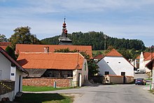
- Folk style homesteads
Sons and daughters of the church
- Vít Fučík (1733–1804), legendary Bohemian aviation pioneer
Individual evidence
- ↑ http://www.uir.cz/obec/550655/Vitejovice
- ↑ Český statistický úřad - The population of the Czech municipalities as of January 1, 2019 (PDF; 0.8 MiB)
- ↑ http://www.uir.cz/zsj-obec/550655/Obec-Vitejovice
- ↑ Johann Gottfried Sommer : The Kingdom of Bohemia, Bd. 8 Prachiner circle. 1840, p. 397


