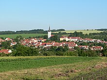
Ostrožská Lhota
| Ostrožská Lhota | ||||
|---|---|---|---|---|
|
||||
| Basic data | ||||
| State : |
|
|||
| Region : | Zlínský kraj | |||
| District : | Uherské Hradiště | |||
| Area : | 635 ha | |||
| Geographic location : | 48 ° 59 ' N , 17 ° 28' E | |||
| Height: | 207 m nm | |||
| Residents : | 1,481 (Jan 1, 2019) | |||
| Postal code : | 687 23 | |||
| License plate : | Z | |||
| traffic | ||||
| Street: | Uherský Ostroh - Hluk | |||
| structure | ||||
| Status: | local community | |||
| Districts: | 1 | |||
| administration | ||||
| Mayor : | Antonín Jelének (as of 2010) | |||
| Address: | Ostrožská Lhota 148 687 23 Ostrožská Lhota |
|||
| Municipality number: | 592455 | |||
| Website : | www.ostrozskalhota.cz | |||
Ostrožská Lhota (German Ostralhota , formerly Ostralhotta ) is a municipality in the Czech Republic . It is located seven kilometers northeast of Veselí nad Moravou and belongs to the Okres Uherské Hradiště .
geography
Ostrožská Lhota is located at the western foot of the White Carpathians in the valley of the Okluky brook . To the northeast rises the Koruny (274 m), in the southeast the Kobylí hlava (358 m), south of the Střečkův kopec (360 m) and Antonínský kopec (350 m) and to the west of the Oborský kopec (240 m).
Neighboring towns are Kunovice and Míkovice in the north, Vlčnov in the northeast, Hluk and Dolní Němčí in the east, Babí Hora, Slavkov , Boršice u Blatnice and Blatnička in the southeast, Blatnice pod Svatým Antonínkem in the south, Veselí nad Moravou and Milokestenora in the south. Ostrožské Předměstí and Kvačice in the west and Chylice and Ostrožská Nová Ves in the northwest.
history
The village was probably created at the beginning of the 13th century in the course of the settlement of the margravial Provincia Lucensis in the Lhot system. The first written mention of Majori Lhota took place on March 26, 1371, when Margrave Johann Heinrich bequeathed the village to his son Johann Sobieslaus in his will . The settlement of Smíchov, which became extinct after the Thirty Years' War, was also mentioned. In Smíchov the toll was collected on the trade route to Nové Mesto . Today's Ostrožská Lhota was later referred to as Lhota Kamenna , Ostrowska Lhota , Lhota Ostroh , Lhota Ostrovská , Lhota Ostro and Lhota Ostra . In 1421 the landlord Hašek von Waldstein , who had owned the property since 1415, got the Catholic parish to accept the Moravian Brothers as a religious community. In 1511 Jan von Kunowitz acquired the Ostroh dominion . After his death in 1549, the inheritance fell to his second son, Jan Jetřich. In 1592 the village consisted of 72 properties. In 1593 Jan Jetřich von Kunowitz inherited the rule of the eponymous grandson. On May 11, 1605, the village was burned down by the troops of the rebellious Transylvanian Prince Stephan Bocskai . In 1617 Jan Bernhard von Kunowitz inherited the rule from his father. Because of his participation in the class uprising of 1618, his possessions were confiscated by Ferdinand II after the battle of the White Mountain and he fled to Transylvania . Between 1620 and 1623 the rule was alternately occupied by the troops of Gábor Bethlens and Karl von Liechtenstein . In 1625 Ferdinand II sold the Ostroh-Kunowitz estate for 30,000 Rhineland guilders to his henchman Gundaker von Liechtenstein . In the course of the recatholicization, the missionary Adalbert Martinides ( Vojtěch Martinides ) worked here , on whose initiative the first church was built around 1655. In 1657 there were ten half-hooves and the mill was desolate. Two quarter hoppers and one cottager were relocated. At the same time, the vineyards on Hradišťskó and Lysina were also mentioned. On September 4, 1663 Ostrožská Lhota was again burned down by troops of the Grand Vizier Ahmed Kiupril under the leadership of the Duke of Saarus (Solnohrad), Michael Apaffy . In 1671 the village consisted of 29 half-farmers, 10 quarter-farmers, 15 gardeners and ten cottagers. In 1674 and 1699 the village was again ravaged by the Turks. In 1705 the Kurucs devastated Ostro Lhota . On November 21, 1765 a locality of the parish Blatnice was established in Ostra Lhota ; this was raised to trustee in 1785. In 1843 the village had 896 inhabitants. Lhota always remained submissive to Ostroh until the middle of the 19th century.
After the replacement of patrimonial Ostrá Lhota / Ostralhotta formed from 1850 a municipality in the district administration Hradisch . During the German War , the Austrian troops brought cholera in 1866 , from which 31 residents died. In 1867 a separate parish was established in Ostrá Lhota . Since 1995 the community has had a coat of arms and a banner. Ostrožská Lhota is the largest of the more than 500 villages that bear the name Lhota .
Community structure
No districts are designated for the municipality of Ostrožská Lhota.
Attractions
- Church of St. James the Elder, built in 1908 in place of a previous building from 1832. The tower is a relic of the old church, which collapsed in 1830
- Statue of John the Baptist, created 1747
- Monument to the victims of the First World War, in front of the church
- Antonínský Kopec, south of the village, with the pilgrimage chapel of St. Anthony of Padua and the Way of the Cross, built after 1650
Sons and daughters of the church
- Antonín Šuránek (1902–1982), Catholic theologian


