Osvětimany
| Osvětimany | ||||
|---|---|---|---|---|
|
||||
| Basic data | ||||
| State : |
|
|||
| Region : | Zlínský kraj | |||
| District : | Uherské Hradiště | |||
| Area : | 1939.16 ha | |||
| Geographic location : | 49 ° 3 ' N , 17 ° 15' E | |||
| Height: | 278 m nm | |||
| Residents : | 876 (Jan. 1, 2019) | |||
| Postal code : | 687 42 | |||
| traffic | ||||
| Street: |
|
|||
| structure | ||||
| Status: | Městys | |||
| Districts: | 1 | |||
| administration | ||||
| Mayor : | Aleš Pfeffer (as of 2018) | |||
| Address: | Osvětimany 350 68742 Osvětimany |
|||
| Municipality number: | 592471 | |||
| Website : | www.osvetimany.cz | |||
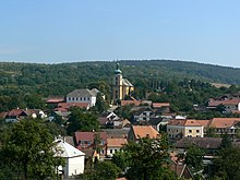
Osvětimany is a minor town in the Okres Uherské Hradiště (German district Hungarian Hradiště ) with about 870 inhabitants in the mountains of the Chřiby (Mars Mountains) about 12 km west of Uherské Hradiště in the Czech Republic .
history
The first written mention of the village comes from 1350. From 1437 it was owned by the Knights Smetana. After their extinction, it passed to the Lords of Zástřizl . From 1550 was Osvětimany part of the rule Buchlov ( Buchlau ).
In 2007 Osvětimany was elevated to Městys ( Minor Town ).
Attractions
- Church sv. Havel (Church of St. Gall )
- Landmarks near Troják
- Fortress of St. Clement , an important archaeological site with the remains of a Slavic-Great Moravian castle from the 9th / 10th centuries. Century, a national historical landmark and a place of pilgrimage dedicated to St. Clement
Web links
Commons : Osvětimany - collection of pictures, videos and audio files


