Břestek
| Břestek | ||||
|---|---|---|---|---|
|
||||
| Basic data | ||||
| State : |
|
|||
| Region : | Zlínský kraj | |||
| District : | Uherské Hradiště | |||
| Area : | 1418 ha | |||
| Geographic location : | 49 ° 6 ' N , 17 ° 21' E | |||
| Height: | 238 m nm | |||
| Residents : | 829 (Jan. 1, 2019) | |||
| Postal code : | 687 07 - 687 08 | |||
| traffic | ||||
| Street: | Buchlovice - Tupesy | |||
| structure | ||||
| Status: | local community | |||
| Districts: | 1 | |||
| administration | ||||
| Mayor : | RNDr. Jindřich Krušina (as of 2020) | |||
| Address: | Břestek 300 687 08 Buchlovice |
|||
| Municipality number: | 592072 | |||
| Website : | www.brestek.cz | |||
Břestek (German Brzestek , older also Prißeck ) is a municipality in the Czech Republic . It is located nine kilometers northwest of Uherské Hradiště and belongs to the Okres Uherské Hradiště .
geography
Břestek is located at the eastern foot of the Mars Mountains in Moravian Slovakia . The village is located in the valley of the Zlechovský potok. The Komínek rises to the north (455 m).
Neighboring towns are Chabaně in the north, Velehrad in the northeast, Tupesy in the southeast, Boršice in the south, Buchlovice in the southwest, Chrastě and Zahrady in the west and Buchlov and Staré Hutě in the northwest.
history
The first written mention of Přestat took place in 1141 as the property of the church in Spytihněv . In 1389 Bohuš from Sazovice was named as the owner. In 1408 the property passed from his daughter Anna to her husband Václav von Morkovice. His son Milota sold the village in 1464 to Mikuláš von Žákov and Jindřich von Buchlovice. Other owners included from 1538 Hynek Podstatský from Prusinovice , who sold the village to the city of Hradiště . In 1549 Nicholas the Elder bought Buchlovický from Domamyslice Brzestek . He died in 1551. His sons left the village to Jan Dánský of Domamyslice, who attached it to the Buchlovice rule . The land register from 1611 shows 44 properties for Brzestek. During the Thirty Years War, the village was burned down in 1643. In the hoof register of 1656 only 20 settler sites were named as cultivated, the remaining 24 were desolate. In 1663 a fire destroyed parts of the village. Until the 18th century Brzestek grew again. In 1843 the grand distillery was built.
After the abolition of patrimonial political community Brzestek originated in 1848 in the district of Uherske Hradiste . In the second half of the 19th century the settlement of Chabaně was created by clearing the bottom of the Chabaňský potok. In 1866, Prussian troops dragged in cholera on their passage , from which 17 residents died and were buried in the cholera cemetery. The current name Břestek has been in use since 1872. In 1880, 800 people lived in Břestek. In 1890 Chabaně consisted of 30 houses and had 119 inhabitants. The Buchlov farm and the Berchtold farm ( Zikmundov ), owned by the May brothers, who also leased the Velehrad estate, also belonged to the cadastre of the municipality at that time . By parceling the estates, 43 smallholdings were created in Břestek in 1923. 1980 Břestek was incorporated into Buchlovice. The municipality of Břestek has existed again since 1990. Břestek is one of the Moravian wine-growing towns .
coat of arms
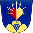
Description: In blue, a heart set with seven gold-emblazoned swords , split in red and gold, over a golden three-mountain topped with a bunch of blue grapes.
Community structure
No districts are shown for the municipality of Břestek. The settlement of Chabaně belongs to Břestek.
Attractions
- Břestecká skála , the rock formation on the western slope of Komínek, is a natural monument
- Giant sequoia from Chabaně , the 32 m high tree was probably planted in the time of Sigmund II von Berchtold and declared a tree monument in 2001
- Chapel of the Seven Sorrows in Břestek, consecrated in 1752
- Bell tower, built in 1888
- Statue of St. John of Nepomuk
- Buchlov Castle and Chapel of St. Barbara, northwest of the village


