Kyjov
| Kyjov | ||||
|---|---|---|---|---|
|
||||
| Basic data | ||||
| State : |
|
|||
| Region : | Jihomoravský kraj | |||
| District : | Hodonín | |||
| Area : | 2988 ha | |||
| Geographic location : | 49 ° 1 ' N , 17 ° 8' E | |||
| Height: | 192 m nm | |||
| Residents : | 11,218 (Jan 1, 2019) | |||
| Postal code : | 697 01 | |||
| License plate : | B. | |||
| traffic | ||||
| Railway connection: | Brno – Vlárský průsmyk | |||
| structure | ||||
| Status: | city | |||
| Districts: | 4th | |||
| administration | ||||
| Mayor : | František Lukl (as of 2006) | |||
| Address: | Masarykovo náměstí 30 697 01 Kyjov 1 |
|||
| Municipality number: | 586307 | |||
| Website : | www.mestokyjov.cz | |||
Kyjov (German Gaya , older also Geyen ) is a town with 11,448 inhabitants (January 1, 2014) in the Czech Republic .
geography
The city is 192 m above sea level. M. southwest of the Martian Mountains on the Kyjovka and belongs to the Okres Hodonín . The long-distance railway connection from Brno to Veselí nad Moravou runs through Kyjov .
Districts
The districts Bohuslavice ( Bohuslawitz ), Boršov ( Borschau ) and Nětčice ( Nietschitz ) belong to the city of Kyjov .
history
The urban area has been inhabited by archaeological finds since the Paleolithic.
In 2010, during construction work on the south-western outskirts of the city, a burial ground with 240 partially richly furnished Longobard graves from the second half of the 6th century was discovered, which must have belonged to a presumed settlement. The find has so far only been partially scientifically developed and provides new insights into the culture and history of the Lombards .
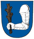
Kyjov was first mentioned in 1126 and belonged to the Hradisko monastery near Olomouc until 1539 . From 1201 the place was named as a town and in 1284 King Wenceslas II allowed the construction of a town fortification. In 1515, Vladislav II granted city rights and the privilege of using a red wax seal.

In 1539 the monastery sold the town together with the village of Bukovany to the Moravian governor Jan Kuna von Kunstadt . Jan Kropáč from Nevědomí on Litenčice later acquired the Kyjov estate. In 1548 the city of Kyjov and Bukovany bought themselves free from subjection and became a royal city . The Kropáč remained the owners of the estate for a long time, followed by the Liechtenstein-Kastelkorn and the Salm-Reifferscheidt . In 1577 the town bought the village of Vřesovice and in 1666 the desert Kelčany was added.
In 1701 Capuchins settled in the town and between 1713 and 1720 built a new church on the market square, which in 1723 was dedicated to the Patronage of the Assumption ( Marian fresco above the portal) and the Moravian patron saints. Cyril and Methodius was consecrated. After the abolition of the monastery in 1784, the Capuchins were expelled from the city.
After the Josephine Tolerance Patent was issued, a significant number of Jews settled there , who lived mainly from trade and commerce and soon played a decisive role in it (see also Synagogue (Kyjov) ). During this time Gaya grew and new streets and buildings were built.
A lignite mine was opened in 1844 under Hugo Karl Eduard Salm-Reifferscheidt . After the abolition of patrimonial Gaya was raised to a district town in 1848 and was also the seat of a judicial district. In 1858 the Salm-Reifferscheidt founded a glassworks that still exists today. In the second half of the 19th century the railway from Austerlitz via Gaya to Bisenz was built and in 1899 the Brno Local Railway Company built the branch line to Mutěnice . During the German occupation, the Jewish residents were deported to concentration camps and only a few survived this period. The synagogue not far from the town hall was damaged by vandalism during this time (it was only demolished in 1962 as part of a city renovation). Today a memorial stone commemorates them. On April 28, 1945 Romanian units of the Red Army occupied the city.
After the Second World War, the city experienced a significant expansion. New industrial and service companies settled here, the hospital was expanded and new settlement areas with the appropriate infrastructure were created. The most important state-owned operations included the glass factory, a large grain mill and a screw factory. The intensive agriculture in the urban area with wine, fruit and vegetable cultivation was also significant. During the territorial reform of 1960, Kyjov lost the status of a district town, but the town remains the economic and cultural center of the surrounding region. After the end of the 40-year planned and state economy in 1989, there was a renewal of private entrepreneurship.
Attractions
- Kyjov Castle, built in 1548 and rebuilt in the 18th century, has housed the town museum with archaeological, historical, natural and folkloric collections in the Renaissance building since 1928
- St. Martin's castle chapel stands on a hill above the town center, its bell tower comes from the parish church that was used until 1786 and later burned out
- Baroque church of the Assumption on the market with an altarpiece by Anton Maulpertsch, originally the Capuchin monastery church with a crypt
- St. Roch Chapel on the highest point of the city on the road to Vlkoš
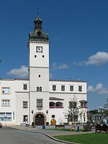
- Town hall on the market square, built in the years 1561/62 in Renaissance style by Italian architects
- Baroque Marian column from 1620 in front of the town hall
- St. Philippius and James in Bohuslavice
Town twinning
Kyjov lists the following six twin cities :
| city | country | since |
|---|---|---|
| Biograd na Moru |
|
2011 |
|
Hollabrunn |
|
2005 |
|
Lutsk |
|
2011 |
|
Prizren |
|
2014 |
|
Seravezza |
|
2011 |
|
Yvetot |
|
1998 |
sons and daughters of the town
- Otto Molitor (1889–1965), Czech painter and sculptor
- Hugo Sonnenschein (1889–1953), German-speaking writer
- Rudolf Adalbert Brachtel (1909–1988), German SS-Hauptsturmführer and concentration camp doctor in the Dachau concentration camp
- Miroslav Tichý (1926–2011), Czech photographer and painter
- Ivo Knoflíček (* 1962), Czech football player
- Jan Vlasák (* 1965), German-Czech writer
- Silvia Saint (* 1976), Czech porn actress and erotic model
- Martin Lejsal (* 1982), football player
- Jiří Koubský (* 1982), Czech football player
- Jan Bárta (* 1984), Czech racing cyclist
Web links
Individual evidence
- ↑ Český statistický úřad - The population of the Czech municipalities as of January 1, 2019 (PDF; 7.4 MiB)
- ↑ Display of the historical map “Regni Bohemiae, Ducatus Silesiae, Marchionatus”. gauss.suub.uni-bremen.de, accessed on December 30, 2014 .
- ↑ statistical information from the Ministry of Interior of the Czech Republic ( memento from September 15, 2009 in the Internet Archive )
- ^ Report from January 18, 2013 at radio.cz
- ↑ Partnerska města Kyjova: Partnerska města: Kyjov. Retrieved April 21, 2019 .
- ↑ www.incotech.cz: Aukce obrazů, Otto Molitor. In: www.galerie-narodni.cz. Retrieved June 20, 2016 .


