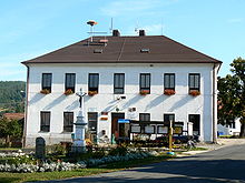
Vřesovice
| Vřesovice | ||||
|---|---|---|---|---|
|
||||
| Basic data | ||||
| State : |
|
|||
| Region : | Jihomoravský kraj | |||
| District : | Hodonín | |||
| Area : | 653 ha | |||
| Geographic location : | 49 ° 4 ' N , 17 ° 13' E | |||
| Height: | 281 m nm | |||
| Residents : | 585 (Jan. 1, 2019) | |||
| Postal code : | 697 01 | |||
| License plate : | B. | |||
| traffic | ||||
| Street: | Koryčany - Osvětimany | |||
| structure | ||||
| Status: | local community | |||
| Districts: | 1 | |||
| administration | ||||
| Mayor : | Hana Výstupová (as of 2010) | |||
| Address: | Vřesovice 72 696 48 Ježov |
|||
| Municipality number: | 586773 | |||
| Website : | www.obecvresovice.cz | |||
Vřesovice , until 1924 Březovice (German Wresowitz , formerly Brzesowitz , Bresowitz ) is a municipality in the Czech Republic . It is located nine kilometers northeast of Kyjov and belongs to the Okres Hodonín .
geography
Vřesovice is located at the southern foot of the Mars Mountains in the Kyjovská pahorkatina hills . The village extends in the valley of the Vřesovický creek up to its confluence with the Skalecký creek. To the north rises the Holý kopec (458 m), in the northeast the Čertova skála (504 m), southeast the Hačky (346 m), in the west the Paní háj (410 m) and to the northwest the Malá Ostrá (480 m), Velká Ostrá (531 m) and the Bradlo (543 m). To the northeast are the Klimentské rybníky ponds, and to the east is the Osvětimany reservoir.
Neighboring towns are Kobylí Doly, Vršava, Lískovec and Střílky in the north, Paseky, Skelná Huť, Stupava , Jantar and Vranovy Žleby in the Northeast, Osvětimany in the east, Hruškovice, Hostějov and Syrovín the southeast, Labuty in the south, Dolní Moštěnice and Moravany in the southwest, Josefinský Dvůr in the west and Podhoří, Zavadilka, Haluzice, Jestřabice, Mouchnice and Koryčany in the northwest.
history
Vřesovice was first mentioned in writing in 1358 when a donation from Margrave Johann Heinrich was recorded for the village of Vřesovice, St. Clement's chapel on the Klemensberg and the Ransberg deserted area to the Augustinian monastery of St. Thomas in Brno . The donation actually took place around 1350, because it was at this time that the Augustinians began to build the monastery on St. Klemensberg. Subsequently, the order established a provost's office in Vřesovice, to which the goods in Vřesovice and the property of the monastery were subordinate. There was a festival in the village. In the 14th and 15th centuries there was also a Freihof in Vřesovice. When the Hussites sacked the monastery in 1421, some of the Augustinians fled to the fortress. Between 1541 and 1549, the Vřesovice order pledged 300 groschen to Georg Puzmann von Perstorf. After the repression of the class uprising of 1548, King Ferdinand I confiscated his goods and initially gave Vřesovice back to the Augustinians. After Vřesovice fell to the king again in 1550, he immediately passed the goods on to Přemek von Víckov. In 1564 Vřesovice fell to the royal town of Kyjov as pledge , which the village bought on July 5, 1577. Since then, Vřesovice has always remained subservient to Kyjov. Until 1748 the village was also under the embarrassing jurisdiction of the Lowczowe prawo (hunting court) on Buchlov . The inhabitants of Vřesovice lived mainly from fruit growing.
After the abolition of patrimonial Březovice / Brzesowitz formed from 1850 a community in the district administration Gaya . In 1874 a village school was established in Březovice. In 1901 the volunteer fire brigade was founded . The municipality has had the official name Vřesovice / Wresowitz since 1924 . After the Okres Kyjov was abolished, Vřesovice was assigned to the Okres Hodonín in 1960.
Community structure
No districts are shown for the municipality of Vřesovice. The settlements Josefinský Dvůr ( Josephshof ), Kobylí Doly, Paseky and Podhoří belong to Vřesovice .
Attractions
- chapel
- Wayside shrine at the crossroads to Osvětimany
- Memorial to those who died in war
- Hora svatého Klimenta ( St. Klemensberg ) with the chapel of St. Klemens, foundation walls of the church and ramparts, archaeological site, three kilometers north in the Mars Mountains, a fortress had been on the mountain since the 9th century, which probably went out in the 12th century. In 1350 the Augustinian hermits built a monastery on St. Klemensberg, which was destroyed by the Hussites in 1421.
- Korichan Chapel (Koryčanská kaple), three kilometers north in the Martian Mountains
- Ruins of Cimburk Castle , five kilometers north in the Martian Mountains
- Osvětimany reservoir, east of the village, recreational area
Web links
Individual evidence
- ↑ Český statistický úřad - The population of the Czech municipalities as of January 1, 2019 (PDF; 7.4 MiB)
- ↑ L. Hošák, R. Šrámek, Místní jména na Moravě a ve Slezsku I, Academia, Praha 1970, II, Academia, Praha 1980th


