Moravany u Kyjova
| Moravany | ||||
|---|---|---|---|---|
|
||||
| Basic data | ||||
| State : |
|
|||
| Region : | Jihomoravský kraj | |||
| District : | Hodonín | |||
| Area : | 1088 ha | |||
| Geographic location : | 49 ° 2 ' N , 17 ° 10' E | |||
| Height: | 248 m nm | |||
| Residents : | 724 (Jan. 1, 2019) | |||
| Postal code : | 696 50 | |||
| License plate : | B. | |||
| traffic | ||||
| Street: | Kostelec - Moravany | |||
| structure | ||||
| Status: | local community | |||
| Districts: | 1 | |||
| administration | ||||
| Mayor : | Petr Kostiha (as of 2010) | |||
| Address: | Moravany 73 696 50 Moravany u Kyjova |
|||
| Municipality number: | 586391 | |||
| Website : | www.obecmoravany.cz | |||
Moravany (German Morawan , formerly Morawann ) is a municipality in the Czech Republic . It is located five kilometers northeast of Kyjov and belongs to the Okres Hodonín .
geography
Moravany is located at the southwestern foot of the Mars Mountains at the confluence of the Moravanský creek in the Čeložnický potok. The Paní háj (410 m) rises to the north, the Šepruny (303 m) to the northeast, the Bohuslavická Nová hora (295 m) to the west and the Zelená hora (305 m) and the Lenivá hora (486 m) to the northwest.
Neighboring towns are Koryčany , Kameňák and Zavadilka in the north, Josefinský Dvůr in the northeast, Labuty and Skalka in the east, Dolní Moštěnice and Ježov in the southeast, Hýsly and Kelčany in the south, Kostelec in the southwest, Bukovany in the west and Bohuslavice and Česteneložnice in the north-west.
history
The first written mention of Moravany took place in 1324, when Vladike Štěpán of Moravany drew as a witness in a comparison between Protivec of Buchlov and the Velehrad Monastery . In the course of the 14th century the property was divided between different members of the widespread Vladiken family, all of whom lived in Moravany. At that time there were three farms and two taverns in Moravany. It is assumed that there was also a fortress, the location of which is assumed to be on the site of today's town hall. Lime has been quarried and lime kilns operated near Moravany since the Middle Ages. In addition, Moravany was home to one of the two iron ore mines in the Mars Mountains, which had been in operation since the 8th century.
Successive sales of individual shares to landlords in the area, such as Zdenko von Sternberg , Mikuláš and Boček from Labuty, Bartoš from Tučapy and Arkle from Zástřizl . Anna von Moravany married Smil von Landstein , who had the predicate “von Morawan” ( z Moravan ) and died in 1381. Their son Johann von Landstein and Morawan († around 1423) first tried to unite the family property in his hands. After buying Milotice in 1412 , he moved his headquarters there and sold Moravany to his stepbrother Protivec von Zástřizl. In 1414 Johann was one of the companions of Jan Hus on the way to Constance. In 1542 Jan Ždánský of Zástřizl Moravany struck the Buchlov rule . Before the 16th century, the inhabitants of the village belonged to the Moravian Brothers. The Buchlov reign refused to give the Brethren land to build a cemetery. In the Buchlauer Urbar from 1611 there is the first evidence of the Morawan quarries. The fractures were in the Mars Mountains on the border of the rulership near the chapel of St. Klemens in the Klimentský potok valley and near Brusnice. In 1624 the preacher Matěj Černý worked in Moravany. When in 1644 the Prakšický von Zástřizl line of Buchlovers became extinct, the rule fell to the lords of Peterswald. After the end of the Thirty Years War, Moravany was re-Catholicized between 1650 and 1651. A little later the cemetery was built. In 1720 there was a wooden town hall in Moravany, in whose vaulted cellars Morawan wine was served. There was also a stately beer tavern, a distillery, two meat banks and a fish pond. The town hall went out in the 18th century. From 1763, the Counts of Berchtold owned the estate, the seat of which was now Buchlovice Castle . A good sandstone was extracted from the quarries of Moravany. Moravany always remained submissive to Buchlovice until the middle of the 19th century.
After the abolition of patrimonial Moravany / Moravan formed from 1850 a community in the district administration Gaya . After the Okres Kyjov was abolished, the place was assigned to the Okres Hodonín in 1960.
Community structure
No districts are shown for the municipality of Moravany. The Kameňák settlement belongs to Moravany.
Attractions
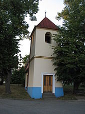
- Bell tower on the village green, built in the 17th century during the time of Matěj Černý
- Chapel of St. Trinity, built 1994-2000, the consecration took place on May 25, 2000 by Archbishop Jan Graubner
- Statue of St. John of Nepomuk, from the middle of the 18th century
- Pardusy, the largest limestone quarries in the Martian Mountains, between Zavadilka and the Korichan Chapel
- Castle stable Paní háj
- Nature reserve Moravanské lúky in the Martian Mountains near Brusnice


