Dehtářský potok
|
Dehtářský potok Dechtern brook |
||
|
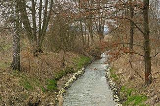
The Dehtářský potok between the ponds Černiš and Dasenský rybník |
||
| Data | ||
| Water code | CZ : 1-06-03-013 | |
| location | Czech Republic | |
| River system | Elbe | |
| Drain over | Vltava → Elbe → North Sea | |
| source | at Vrábče station , Blanský les 48 ° 55 ′ 7 ″ N , 14 ° 21 ′ 29 ″ E |
|
| Source height | 509 m nm | |
| muzzle | east of Bavorovice in the Moldau Coordinates: 49 ° 1 '24 " N , 14 ° 26' 41" E 49 ° 1 '24 " N , 14 ° 26' 41" E |
|
| Mouth height | 374 m nm | |
| Height difference | 135 m | |
| Bottom slope | 5.5 ‰ | |
| length | 24.5 km | |
| Catchment area | 143.8 km² | |
| Drain |
MQ |
610 l / s |
The Dehtářský potok (German Dechtern Bach ) is a left tributary of the Moldau / Vltava in the Czech Republic .
course
The Dehtářský potok rises in the eastern foothills of the Blanský les . Its source is located 100 m northeast of the Vrábče train station in the Zastávka settlement. The upper course of the stream leads north past the places Zahrádka, Slavče ( Slavtsch ), U Veverků ( Wewerka ), U Konopí, Hradce , Lipí , Habří , Bedlan, U Zedníků, Kvítkovice and Na Kotlovech into the Budweiser Basin. At Kvítkovice, the brook is dammed in Kvítkovický rybník, the pond is the first large pond on Dehtářský potok. The villages of Nový Mlýn ( Neumühle ), Čakovec ( Klein Čekau ), Dubné and Podvrážský Mlýn ( Karlmühle ) follow along the stream . At Vráže ( Wraz , 480 m nm) near Čakov , the Dehtářský potok takes a north-westerly direction and flows into the seventh largest pond in the Czech Republic, the Dehtář , at Holubovská Bašta ( Baschten ) . At Dehtáře the stream leaves the pond to the east.
Its further course leads past Žabovřesky , Žabovřeský Mlýn, Na Drahách, Břehov , Jaronice and Čejkovice into the Blata, where the Dehtářský potok at the Mlýnský rybník pond is connected to the Dubenský potok via a system of ditches. After that, along the stream, the towns of Nové Dvory ( Neuhof ), Vodal and Dasný are located . At its lower reaches, the Dehtářský potok at the Vrbenské rybníky ponds heads northeast and is bridged between České Vrbné ( Bohemian Fellern ) and Bavorovice ( Baurowitz ) by the state road I / 20 / E49 and the railway line České Budějovice – Veselí nad Lužnicí . After 24.5 kilometers, the Dehtářský potok joins the Vltava east of Bavorovice .
The Dehtářský potok is regulated and straightened for most of its course.
Tributaries
- Čakovecký potok (l), near Čakovec below the Dlouhý u Čakova pond
- Jankovský potok (l), near Čakov
- Kamenný potok (l), above Holubovská Bašta in the Dehtář
- Babický potok (l), near Strýčice in the Dehtář
- Jaronický odpad (r), near Jaronice
- Dubenský potok (r), near Vodal
- Blatec (r), by the Černiš pond
Flowing ponds
- Kvítkovický rybník ( Kwitkowice Pond ), 25 ha, near Kvítkovice
- Dlouhý u Čakova ( Long Pond ), 13 ha, near Čakovec
- Podvrážský rybník ( mill pond ), 5.12 hectares, near Čakov
- Dehtář ( Dechtern pond ), 246 ha, near Dehtáře
In the Blata pond landscape, there are numerous other ponds on both sides of the stream, which are fed by the Dehtářský potok via ditch systems.

