Červená (Jetětice)
| Červená | ||||
|---|---|---|---|---|
|
||||
| Basic data | ||||
| State : |
|
|||
| Region : | Jihočeský kraj | |||
| District : | Písek | |||
| Municipality : | Jetětice | |||
| Geographic location : | 49 ° 22 ' N , 14 ° 17' E | |||
| Height: | 420 m nm | |||
| Residents : | 101 (March 1, 2001) | |||
| Postal code : | 398 43 | |||
| License plate : | C. | |||
| traffic | ||||
| Street: | Jetětice - Truhlařov | |||
| Railway connection: | Tábor – Písek | |||
| Next international airport : | České Budějovice Airport | |||

Červená (German Tscherwena , also Čerwena ) is a district of the municipality Jetětice in the Czech Republic . It is located eleven kilometers southwest of Milevsko in South Bohemia and belongs to the Okres Písek .
geography
Červená is located in Milevská pahorkatina, part of the Central Bohemian hill country. The settlement lies on a plateau to the right of the confluence of the Jetětický creek into the Orlík reservoir . The Kopeniny (522 m) rise to the east, the Petrův vrch ( Peterberg , 482 m) in the south-west and the Otava (453 m) in the north-west. Červená is bypassed in a loop in the east, south and west by the Tábor – Písek railway line . At the southwest exit of the town is the Červená nad Vltavou train station , to the northwest the railway bridge over the Vltava valley .
Neighboring towns are Jetětické Samoty in the north, Jetětice , Stehlovice and Jižiny in the northeast, Hajnice, Podolí and Křenovice in the east, Myslivna and Podolí I in the south-east, Olešná , Podolsko and Temešvár in the south, Pazderna, Zálesi, Strušina in the south , Babák and Červený Újezdec in the west and Truhlařov, Habr, Tukleky, Pazderny, Oslov , Zběrov and Červená 2. díl in the northwest.
history
Until the 19th century, the plateau over the Vltava valley in the border area between the dominions of Wopařan and Klingenberg north of Podolsko existed with dense forests, in which the remote farms of Pazdera ( Pazderna ), Pepřil and Kopaničky ( Truhlařov ) and a manorial Hegerhaus ( Habr ) were located . The remote farms of Gilowetz ( Jílovec ) and Křenek as well as the Saniker Mill were located in the Vltava Valley . Later, with Čerwena and Na Samotech ( Jetětické Samoty ), other single farms were added.
In 1840 the single-layer Čerwena, Jílovecký Mlýn ( Jílovecký Mlýn ), Sanikers mill ( Saník ) and a single-layer Na Samotech ( Jetětické Samoty ) house belonged to the village of Čerwena , and another house in Na Samotech to the village of Jetietitz . As part of the rule of Klingenberg, they were subject to the Fideikommissherrschaft Worlik including the allodial goods Zalužan, Zbenitz and Bukowan. The third house in Na Samotech belonged to the village of Podolsko and was subject to the allodial rule Wopořan and Bernaditz. The parish and school location was the village of Čerwena.
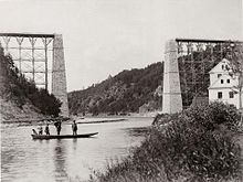
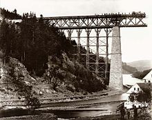
After the abolition of patrimonial , the strata belonged to the village of Červená / Čerwena and together with this they formed from 1850 a district of the municipality of Jetětice in the district and judicial district of Milevsko. The construction of the Tábor - Milevsko - Písek - Ražice railway between 1886 and 1889 tore the area out of its isolation. The Červená nad Vltavou train station was laid out in the forest east of the Pazderna farmstead and the railway bridge over the Vltava valley was built near the Saník mill. In the following years, the Červená settlement was built next to the train station and the Jetětické Samoty that followed grew into one settlement.
Between 1956 and 1963 the Orlík Dam was built , flooding the Červená 1. díl and Červená 3. díl and the Jílovec, Křenek, Saník, Šejharův Mlýn and Šimek strata. A ship landing stage and recreational facilities, including a hotel, were built at the reservoir. After the Okres Milevsko was abolished, Červená was assigned to the Okres Písek in late 1960 . In 1991 the district Červená had 94 inhabitants, at the 2001 census 101 people lived in the 64 houses.
Community structure
The district Červená is part of the cadastral district Jetětice. It includes the settlements of Červená and Jetětické Samoty as well as the layers Habr, Pazderna and Truhlařov.
Attractions
- Chapel of the Virgin Mary of Lourdes in Jetětické Samoty, built in the 1st half of the 20th century
- Wayside cross at Jetětické Samoty
- Railway bridge at Červená, the 253 m long structure on two stone pillars 68 m high was built between 1886 and 1889. It was the first railway bridge in Bohemia that was erected in a flying assembly without scaffolding.
literature
- Josef Kytka: Milevsko a jeho kraj: turistika, památky, historie , Milevsko: Nákladem odboru klubu českých turistů, 1940
Individual evidence
- ↑ Johann Gottfried Sommer The Kingdom of Bohemia, Vol. 9 Budweiser Kreis, 1840, p. 64
- ↑ Johann Gottfried Sommer The Kingdom of Bohemia, Vol. 10 Taborer Kreis, 1842, p. 46


