Terbuny
| Village
Terbuny
Terbuny
|
||||||||||||||||||||||||||||||||||
|
||||||||||||||||||||||||||||||||||
|
||||||||||||||||||||||||||||||||||
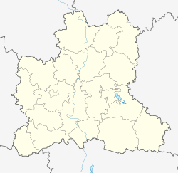
Terbuny ( Russian Тербуны́ ) is a village (selo) in the Lipetsk Oblast ( Russia ) with 7,312 inhabitants (as of October 14, 2010).
geography
The village is located about 100 kilometers as the crow flies southwest of the Lipetsk Oblast Administrative Center on the flat ridge that extends a good 10 km east of the Olym, which flows north there, in the Don river system .
Terbuny is the administrative center of Terbunski Rajons as well as the seat of the rural community Terbunski selsowet, to which the ten villages Danilowskije Vyselki, Iljuchino, Lobanowka, Malyje Borki, Nabokowo, Nagornoje, Plechanowka, Prudki, Sini Kamen and Wassiljewka are located (5 km away, the largest, 471 Inhabitants 2010), all of which are about 2 to 13 km southwest to west-southwest of Terbuny.
history
The place was created in 1897 in connection with the construction of a station on the railway line from Moscow via Jelez and Waluiki to the Donets Basin . The station was named after the village of Terbuny, 14 km to the east , today Wtoryje Terbuny ("Second Terbuny"). A settlement grew around the station located in Ujesd Jelez in the Orjol governorate , and on July 30, 1928 it became the administrative seat of a rajon named after it. The Rajon initially belonged to the Central Black Earth Oblast (Zentralno-Chernosjomnaja oblast), from its division on December 31, 1934 briefly to Voronezh Oblast , but already from January 18, 1935 to Kursk Oblast , until the formation of Lipetsk Oblast on January 6th 1954.
During the Second World War , Terbuny was twice in the immediate vicinity of the front. The Red Army was able to stop the advance of the German Wehrmacht along a line a few kilometers to the south : for the first time on December 5, 1941, until the Red Army went over to the counter-offensive on December 8, and again on July 2, 1942, when the Wehrmacht moved further south-east Voronezh advanced. On January 27, 1943, the Red Army went on the offensive as part of their Voronezh-Kastornoje operation near Terbuny.
From 1975 to 1992 Terbuny had urban-type settlement status .
Population development
| year | Residents |
|---|---|
| 1926 | 613 |
| 1939 | 1455 |
| 1959 | 2272 |
| 1970 | 3754 |
| 1979 | 5138 |
| 1989 | 6702 |
| 2002 | 6998 |
| 2010 | 7312 |
Note: census data
traffic
Terbuny is at 495 km of the railway line from Moscow via Jelez to Waluiki.
From the northern neighboring district center Dolgorukowo to Terbuny the railway line follows the regional road 42K-224 of the railway line coming from Jelez on the federal trunk road M4 Don . In an easterly direction there is also a connection to the M4 at the Khlvnoe district administrative center via the 42K-687 . The 42K -001 runs from Terbuny to the neighboring district of Wolowo to the southwest .
Individual evidence
- ↑ a b Itogi Vserossijskoj perepisi naselenija 2010 goda. Tom 1. Čislennostʹ i razmeščenie naselenija (Results of the All-Russian Census 2010. Volume 1. Number and distribution of the population). Tables 5 , pp. 12-209; 11 , pp. 312–979 (download from the website of the Federal Service for State Statistics of the Russian Federation)


