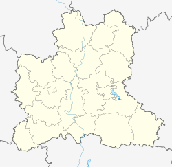
Chaplygin
| city
Tchaplygin
Чаплыгин
|
||||||||||||||||||||||||||||||||||||||||||
|
||||||||||||||||||||||||||||||||||||||||||
|
||||||||||||||||||||||||||||||||||||||||||
| List of cities in Russia | ||||||||||||||||||||||||||||||||||||||||||
Chaplygin ( Russian Чаплыгин ) is a city in the Lipetsk Oblast ( Russia ) with 12,656 inhabitants (as of October 14, 2010).
geography
The town in the region of the transition of the Central Russian Upland to Oka-Don plain about 85 km north of the Oblasthauptstadt Lipetsk , in the union of the river Jagodnaja Rjassa , Guschtschina Rjassa and Stanowaja Rjassa to Stanowaja , a right tributary of the Don opens Voronezh .
Tschaplygin is the administrative center of the Rajons of the same name .
history
In the place of today's city, a settlement was built in the first half of the 17th century along the Belgorod defense line along the then southeastern border of the Russian Empire. It was first mentioned in 1638 and later called Slobodskoje .
In 1695, on the high bank of the Jagodnaya Ryassa, a small wooden palace was built for the overnight stays of Tsar Peter the Great and his companions on journeys between Moscow and Voronezh . A little later, Peter laid the foundation stone for a small fortress based on the Dutch model, which he named Oranienburg (analogous to the city of Oranienburg in Germany).
In 1702 the Tsar donated the fortress Oranienburg and the village of Slobodskoje to his confidante Alexander Menshikov , who in 1712 also provided the funds for the construction of the Peter and Paul Monastery in the vicinity. In 1727, after his fall, Menshikov was initially banished to Oranienburg , as was the former regent Anna Leopoldowna who had been overthrown in 1742 .
The name of the fortress was soon transferred to the village and, over time, simplified to Raninburg , then Ranenburg . On September 16, 1778, the place received the latter name as the administrative center of a district (Ujesds).
In the 19th and early 20th centuries, Ranenburg was an important center for the grain trade.
In 1948 the name was changed to Tschaplygin in honor of the pioneer of aerodynamics Sergei Tschaplygin (1869–1942), who was born here .
Population development
| year | Residents |
|---|---|
| 1897 | 15,331 |
| 1926 | 9,600 |
| 1939 | 6,068 |
| 1959 | 10,713 |
| 1970 | 13,671 |
| 1979 | 13,407 |
| 1989 | 14,343 |
| 2002 | 13,656 |
| 2010 | 12,656 |
Note: census data (1926 rounded)
Culture and sights
In the city are the Trinity Cathedral ( Троицкий собор / Troitski sobor) from 1818 with a bell tower (around 1838), the Resurrection Church ( Вознесенская церковь / Voznesenskaya zerkow) from the end of the 18th century, the building of the former clergy school from the end of the 18th century The school and residential buildings from the 19th century have been preserved.
The city has a history and local museum .
In the village of Urusovo in Chaplygin Raion there is a memorial museum for the geographer, botanist and statistician Pyotr Semjonow-Tjan- Shansky who was born there . There, as in the villages of Solnzewo and Denissowka , there are also larger parks at former aristocratic seats.
Economy and Infrastructure
In Tschaplygin there is a supplier plant for tractor construction, a furniture factory and companies in the food and textile industries.
The city lies on the railway line Moscow ( Pawelezer Bahnhof ) - Pawelez - Bogojawlensk (- Tambov / Voronezh; station name Ranenburg ; route kilometers 334 from Moscow), from which a line branches off to Jelez .
The M6 Moscow - Volgograd - Astrakhan highway passes Chaplygin around 20 kilometers away.
sons and daughters of the town
- Dmitri Ilowaiski (1832–1920), historian and publicist
- Leonid Radin (1860–1900), revolutionary
- Sergei Tschaplygin (1869–1942), aerodynamicist and namesake of the city
Web links
- Tschaplygin on mojgorod.ru (Russian)
Individual evidence
- ↑ a b Itogi Vserossijskoj perepisi naselenija 2010 goda. Tom 1. Čislennostʹ i razmeščenie naselenija (Results of the All-Russian Census 2010. Volume 1. Number and distribution of the population). Tables 5 , pp. 12-209; 11 , pp. 312–979 (download from the website of the Federal Service for State Statistics of the Russian Federation)


