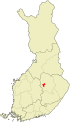
Tervo
| coat of arms | map |
|---|---|

|

|
| Basic data | |
| State : |
|
| Landscape : | North Savo |
| Administrative community : | Inland Savo |
| Geographical location | 62 ° 37 ′ N , 26 ° 50 ′ E |
| Surface: | 494.18 km² |
| of which land area: | 347.68 km² |
| of which inland waterways: | 146.50 km² |
| Residents : | 1,567 (Dec. 31, 2018) |
| Population density : | 4.5 inhabitants / km² |
| Municipality number : | 844 |
| Language (s) : | Finnish |
| Website : | www.tervo.fi |
Tervo [ ˈterʋo ] is a Finnish municipality. It is in the countryside Savo approximately 58 kilometers from Kuopio and 420 kilometers from Helsinki center. Only Finnish is spoken in the community.
politics
Municipal council
As in most rural areas in Finland, the rural-liberal Center Party is the strongest party in Tervo . In the local council she achieved an absolute majority in the 2017 local elections with almost 57% of the vote and ten out of 17 MPs. The conservative National Assembly Party has three MPs. The Social Democrats and the right-wing populist True Finns each have two seats on the municipal council.
| Political party | Election result 2017 | Seats |
|---|---|---|
| Center Party | 57.8% (+7.5) | 10 (+1) |
| National rally party | 16.6% (+3.0) | 3 (+1) |
| True Finns | 14.3% (−8.6) | 2 (−2) |
| Social democrats | 11.2% (+0.1) | 2 (± 0) |
Town twinning
Tervo maintains a since 1945 twinning with Hurdal in Norway since 1989, with Rajon Prioneschsk in Russia .
Sons and daughters
- Sinikka Kukkonen (* 1947), orienteer and ski orienteer
- Sirpa Kukkonen (* 1958), ski orienteer
- Marco Hietala (* 1966), bassist and singer in the Finnish metal bands Nightwish and Tarot
Individual evidence
- ↑ Maanmittauslaitos (Finnish land surveying office): Suomen pinta-alat kunnittain January 1, 2010 (PDF; 199 kB)
- ↑ Statistical Office Finland: Table 11ra - Key figures on population by region, 1990-2018
- ↑ Finnish Ministry of Justice: Result of the 2017 local elections
Web links
Commons : Tervo - collection of images, videos and audio files