Teufelsberg (Rhön)
| Teufelsberg | ||
|---|---|---|
|
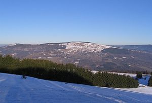
View of the Himmeldunkberg ridge, |
||
| height | 844 m above sea level NHN | |
| location | at Bischofsheim ; District of Rhön-Grabfeld , Bavaria ( Germany ) | |
| Mountains |
Rhön ( High Rhön ) |
|
| Coordinates | 50 ° 25 '17 " N , 9 ° 56' 54" E | |
|
|
||
The Teufelsberg , located between Bischofsheim and Gersfeld in the Franconian district of Rhön-Grabfeld , is 844 m above sea level. NHN high mountain of the High Rhön , part of the low mountain range Rhön . The eastern neighbor is the Himmeldunkberg ( 888 m ) with which the Teufelsberg initially forms the side mountains of the Hohe Hölle and with other mountains of the Hohe Rhön the ridge of the Dammersfeldrücken .
geography
location
The summit of the Teufelsberg is a rather inconspicuous part of the Dammersfeld ridge and hardly stands out between Himmeldunkberg and Simmelsberg . It is - viewed counterclockwise - 3.7 km southeast of Gersfeld, 1.8 km north of Oberweißbrunn and 5 km northwest of Bischofsheim (in each case as the crow flies ).
West of the Teufelsberg there is a pass (height xxx m) through the Dammersfeld ridge, on the northwestern slope of the mountain lies the source of the Brend .
Natural allocation
The Teufelsberg belongs to the main natural unit group Osthessisches Bergland (No. 35), the main unit Hohe Rhön (354) and the subunit Südliche Hochrhön (354.0) to the natural area Dammersfeldrücke (354.00).
rock
The Teufelsberg lies on the western edge of the basalt cover, which is particularly noticeable in the area of the Langen Rhön .
Protected areas
The Teufelsberg is located in the Bavarian Rhön landscape protection area ( CDDA no. 396113; 95.98 km² ), in the Bavarian Rhön nature park , in the Rhön biosphere reserve , and in the Bavarian High Rhön fauna-flora-habitat area (FFH no. 5526-371 ; 19.02 km²) and in the bird sanctuary Bayerische Hohe Rhön (VSG no. 5526-471; 19.02 km²).
Infrastructure, traffic and hiking
The Teufelsberg is separated from the western part of the Dammersfeldrücken with the Dammersfeldkuppe and the Wildflecken military training area by the federal road 279 , which runs directly at its foot and can be easily reached. There is a parking lot on the road at the inn Schwedenschanze, from which a local hiking trail starts, the Main-Werra Weg long-distance hiking trail and the Fulda-Schweinfurt Jakobsweg also lead over the summit . From the unwooded upper part of the mountain you have a good view of the Kreuzberg and towards the Dammersfeldkuppe.
Individual evidence
- ↑ a b c d Map services of the Federal Agency for Nature Conservation ( information )
- ↑ a b c d Rhönklub eV (Ed.): Schneider's Rhönführer, official guide of the Rhönklub . 25th edition. Parzeller, Fulda 2005, ISBN 3-7900-0365-4 , p. 278 .
- ↑ Teufelsberg-Himmeldunkberg ridge on opentopmap.org . Retrieved July 1, 2015.
- ↑ All distances were measured using GoogleMaps.
- ↑ a b Hiking map of the Rhön Nature Park, 1: 50000 . 10th edition. Fritsch-Verlag, ISBN 3-86116-068-4 .
- ↑ Map at Protected Planet . Retrieved July 1, 2015.
- ↑ Directions for the Jakobsweg Fulda-Schweinfurt on the pages of the Franconian St. Jakobus Society. Retrieved July 7, 2015.

