Simmelsberg
| Simmelsberg | ||
|---|---|---|
|
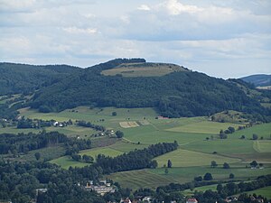
View from Wachtküppel southeast to the Simmelsberg; in front houses from Gersfeld , in the middle right the woodless Rodenbacher Küppel with houses in Rodenbach , in the middle left the Dammelhof |
||
| height | 842.7 m above sea level NHN | |
| location | near Rodenbach ; District of Fulda , Hessen , Germany | |
| Mountains | Rhön | |
| Coordinates | 50 ° 25 '46 " N , 9 ° 56' 19" E | |
|
|
||
| Normal way | from the parking lots at Schwedenschanze , Dammelhof or Schwedenwall | |
The Simmelsberg near Rodenbach in the Hessian district of Fulda is 842.7 m above sea level. NHN high mountain in the Rhön - near the border with Bavaria .
geography
location
The Simmelsberg rises in the Hessian Rhön Nature Park and in the Rhön Biosphere Reserve . Rodenbach is at its north-west foot . The mountain peak is around 2.5 km southeast of Gersfeld , 1.8 km south-southwest of Mosbach and 1.8 km (as the crow flies ) east of Rengersfeld . On the other side of the nearby Bavarian border lies Oberweißbrunn . On the Bergsüdflanke springs the Brend and on the eastern flank of the Bach Steche creators , in the west of the mountain flowing savings Broder water flows.
Neighboring mountains and elevations are the Galgenberg in the north, the Hohe Hölle ( 893.8 m ) in the east, the Himmeldunkberg ( 887.9 m ) in the east-southeast, the Teufelsberg ( 844 m ) in the southeast, the Reesberg ( 851.2 m ) in the southwest and the Rodenbacher Küppel ( 680.2 m ) in the northwest.
Natural allocation
The Simmelsberg belongs to the natural spatial main unit group Osthessisches Bergland (No. 35), in the main unit Hohe Rhön (354) and in the subunit Südliche Hohe Rhön (354.0) to the natural area Dammersfeldrücke (354.00). To the north, in the main unit Vorder- und Kuppenrhön (353) and in the subunit Kuppenrhön (353.2) the natural area Milseburger Kuppenrhön (353.21) joins.
Protected areas and nature

Parts of the Hohe Rhön landscape protection area ( CDDA no. 378482; designated 1997; 44.2 km² in size), the fauna-flora-habitat area Hochrhön (FFH no. 5525-351; 48.09 km²) and of the Hessian Rhön bird sanctuary (VSG no. 5425-401; 360.80 km²). The lower flanks of the mountain are largely forested. The forest cover extends from the east and south-east to the summit area. The upper area of the north side as well as large parts of the west flank are free of forests up to the highest positions and covered with grass turf.
leisure
The Simmelsberg is a popular destination for hikers and mountain bikers because its summit region offers good views, including Gersfeld, Heidelstein and Wasserkuppe . When the visibility is good, the view extends in the northwest to the Knüllgebirge and Kellerwald and in the west to the Taunus and Vogelsberg . In winter the winter sports area Simmelsberg on the eastern slope of the mountain is a magnet for tourists. There is the Frankfurter Hütte , an unmanaged self-catering accommodation for the Frankfurter Rhön Club.
Traffic and walking
In its section between Gersfeld and Oberweißbrunn, the federal road 279 leads west past the Simmelsberg and overcomes a 715 m high mountain pass at the Schwedenschanze . At Rodenbach a narrow road branches off, which leads around the Simmelsberg north and runs through Rodenbach past Dammelhof to Mosbach on the state road 3396. The shortest ascent to the Simmelsberg begins at the Schwedenschanze south of the mountain or at the Dammelhof north of it and takes around 40 minutes. They unite on the mountain saddle between Simmelsberg and Himmeldunkberg or Teufelsberg at about 780 m altitude and then lead from the southeast to the summit.
See also
Web link
- On the Simmelsberg - view from the Simmelsberg (labeling of visual targets can be activated), on panorama-photo.net
Individual evidence
- ↑ a b c Map services of the Federal Agency for Nature Conservation ( information )
- ↑ Frankfurter Hütte am Simmelsberg , on rhoenclub.de


