Heavenly Dunk Mountain
| Heavenly Dunk Mountain | ||
|---|---|---|
|
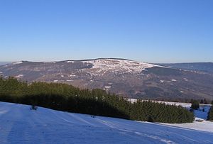
View from the Arnsberg to the north to the Himmeldunkberg |
||
| height | 887.9 m above sea level NHN | |
| location | Bavaria / Hessen , Germany | |
| Mountains | Rhön (High Rhön) | |
| Coordinates | 50 ° 25 '22 " N , 9 ° 57' 35" E | |
|
|
||
| Type | extinct volcano | |
| rock | Basalt and tuff | |
The Himmeldunkberg or Himmeldunk is a 887.9 m above sea level. NHN high mountain of volcanic origin in the Rhön .
Surname
The name can be traced back to a mention during the establishment of the boundaries of the Wildbanns Hugimuododung ( Old High German ), which was given to the Fulda Abbey by King Heinrich IV in 1059 , which means 'mountain of the woman Hugimuot'. In Middle High German it became Hügemodetunc, Hümededunc, Himmeldunk . The term "Himmeldankberg", which is sometimes still to be found, goes back to incorrect naming by law firms and cartographers.
Location and surroundings
The Himmeldunkberg and the Hohe Hölle form a double peak, the northeastern end of the Dammersfeld ridge . A good 5 km to the northeast are the Rote Moor and the Heidelstein , the southwestern part of the Long Rhön , which is part of the Central Rhön . The village of Oberweißbrunn is 2 km south, 4 km south-east Bischofsheim in the Rhön and 3 km north-west Gersfeld .
The Rhine-Weser watershed , the Rhön-Höhen-Weg (RHW) and the border between Bavaria and Hesse run over the summit of the Himmeldunkberg , with the exact summit a few hundred meters south of the border in Bavaria. The boundary stones set in 1872 testify to the former border between the Kingdom of Bavaria and the Kingdom of Prussia.
geology
The Himmeldunkberg consists mainly of the volcanic rocks basalt and tuff .
description
The northern slope drops off steeply and is covered with mixed deciduous forest. The south-west to east-facing slope is unforested, mainly grass, sloes , rose hips , silver thistles and bluebells grow here .
The summit plateau offers an excellent view over Bischofsheim to Kreuzberg , Osterburg , Arnsberg , the Black Mountains, Schachen, Eierhauck , Dammersfeld , Reesberg, the valley of the Brend and the upper sense . When visibility is very good, the view extends as far as the Fichtel Mountains .
The Himmeldunkberg lies in the field of tension between nature conservation and recreational activities, as on the one hand it is an ecologically sensitive and unique area and on the other hand it is an attractive destination for hikers and mountain bikers because of the view. In addition, it has the only suitable terrain for motorless air sports with east / south-east exposure within a radius of about 50 km. Mountain biking is only allowed on trails with the mountain bike sign. Hang gliders and paragliders no longer use the mountain, model flying is only possible to a limited extent.
On the southeast slope stands at 835 m above sea level. NHN the Würzburger Bergbund hut , a self-catering hut belonging to the DAV Bergbund Würzburg section. Plans to relocate the hut to a less conflict-ridden area in terms of nature conservation failed due to a lack of funding.
About 150 m southwest below the summit are the witches' beeches , a group of old red beeches that used to protect grazing animals from the sun and weather.
See also
Individual evidence
- ↑ a b Map services of the Federal Agency for Nature Conservation ( information )
- ↑ HAAS, TH. The mountain names of the Rhön. In: Fuldaer Geschichtsblätter 1/1925 p. 9.
- ↑ RC-Network.de , accessed on June 2, 2012.
- ↑ 50 years of the Würzburger Bergbund Hut (1958-2008) ( Memento from September 30, 2015 in the Internet Archive )
- ↑ The Witches' Book at Himmeldunk ( Memento from May 25, 2013 in the Internet Archive )
Web links
- From the Rhön to the Fichtelgebirge - panorama from the Himmeldunkberg (labeling of visual targets can be activated), on panorama-photo.net


