
Theodosian wall
| Theodosian wall | |
|---|---|
| Alternative name | İstanbul Surları |
| limes | Thrace |
| Dating (occupancy) | C 413 to c 1453 |
| Type | Triple wall system of late antiquity |
| unit | Various city garrison units |
| size | Length: 20 km, width approx. 70 m |
| Construction | Limestone / brick |
| State of preservation | Land walls above ground are still visible in large parts and have been partially restored, lake walls only exist in fragments |
| place | Istanbul |
| Geographical location | 41 ° 1 '5 " N , 28 ° 55' 24" E |


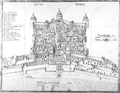
| The sea walls at the Bukoleon Palace |
|---|
| Antoine Helbert |
|
Link to the picture |
The Theodosian Wall ( Turkish İstanbul Surları or Topkapı Surları ) is a 19-20 kilometer long fortification (land and sea walls ) built at the beginning of the 5th century under Emperor Theodosius II and the Prefect Anthemius to protect Constantinople , today's Istanbul .
The Theodosian Wall is considered by some historians to be one of the most successful and well thought-out fortifications in the history of war technology. Many of the most dramatic events in the history of the city are closely related to this extraordinary structure. The construction of the wall system was necessary to counter the threat posed by the Huns and to give the rapidly expanding city additional space. Despite increasing decay and the emergence of firearms, the fortifications were difficult to overcome even in the middle of the 15th century if the defense was resolute. The complexity of the defensive structures contributed significantly to the long existence of the Byzantine Empire .
development
Under the reign of Theodosius II , the appearance of the Eastern Roman capital changed most strongly and most visibly since it was founded by Constantine I. A fortress system was created that astonishes even as a ruin.
Two reasons were decisive for the large-scale project: In the course of the 4th century, the city had grown further and further beyond the Constantinian Wall, and many houses were now completely unprotected on the flat land. The second, much more worrying reason was the sack of the ancient capital Rome by Gothic federates under Alaric I in 410. Although the imperial residence of the western empire had long been moved to the naval base in Ravenna , this news came as a serious shock to the Roman world , especially in Constantinople, where they saw themselves as the guardians and keepers of the greatness and tradition of ancient Rome. In addition, Hunnic tribes began to infiltrate the Danube and settle in Thrace , practically at the gates of the city.

The first construction phase of the new city wall - at that time a simple one instead of the later triple wall ring - was completed in 413. For this purpose it was pushed two kilometers outside the old Constantinian city wall to the west. The client was the Praetorian prefect Anthemius, guardian of the twelve-year-old Theodosius and the actual ruler of the East. Due to the additional area gained, the urban area expanded by more than half. This proved more than sufficient for the city's future expansion. This new land was never completely built over and was used for agriculture in Byzantine / Ottoman times. Shortly after its completion, on January 27, 447, in the second hour after midnight, it was badly damaged by an earthquake . As a result, the wall and 57 of its towers had collapsed in some sections. This point in time was extremely unfavorable, as the Huns under Attila massively threatened the Eastern Roman Empire and its capital. Almost the entire area around the Golden Horn was in ruins. The Praetorian Prefect of the East Constantius immediately organized "flying commands" to clear the trenches of rubble and rebuild the fortifications. Within only two months by the end of March 447 the wall was rebuilt even higher and stronger than before in a joint effort of the city population (deployment of an estimated 16,000 men). Not only was the original wall rebuilt, but an outer wall with towers and a parapet in front was added. This amazing building achievement was celebrated in an inscription:
- “In less than two months, the successor of Constantine erected the triumphant work of these strong walls. Pallas could hardly have built such a strong bulwark so quickly. "
Shortly before the appearance of the Hunnish army, the city was ready for defense again. Attila decided against a siege and instead invaded the Western Roman Empire . A later construction phase of the wall is based u. a. on the plans of Anthemios von Tralleis , a leading architect of the 5th century.
Arabs, Bulgarians, Russians and Pechenegs invaded the city again and again, but without success. In 764 the sea wall was damaged during an extremely harsh winter, the chronicler Theophanes reports that the Black Sea froze up to 100 miles from the shore that year. The snow piled up on the ice up to 15 m high. When the thaw set in, icebergs even drifted on the Bosporus, which soon blocked the entrances to the Marmara Sea and Golden Horn . The quays were rammed by a particularly large iceberg which, when it ran aground, broke into three parts and was still higher than the sea wall. In 1203/1204 the army of the 4th Crusade succeeded in entering the city by chance over the less well fortified sea walls and almost completely pillaging it. The Byzantine imperial residence was never to recover from this catastrophe. In 1344 another particularly violent earthquake devastated the region, and the wall had to be painstakingly repaired along its entire length.
The land wall was stormed on May 29, 1453 by the numerically and technically superior army of Sultan Mehmed II . The seven-week siege of Constantinople that preceded this event had nevertheless been extremely arduous and costly for the Ottomans, although the city was already largely depopulated and completely impoverished. For almost 1000 years the fortifications had been a reliable protection for the city and its citizens. When his capital finally fell to the Ottomans , the end of the Byzantine Empire was sealed. After that, most of the fortifications were left to decay, and the Gecekondu residents used them as a quarry for a long time. In the last decades of the 20th century, however, they began to be partially restored and preserved.
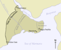
The country wall
Few cities owe as much to their favorable location as Constantinople, because the city is surrounded on three sides by the sea:
- from the Golden Horn in the north,
- from the Bosphorus to the east and
- from the Propontis (Sea of Marmara) in the south.


After the Hagia Sophia , no other building had such a sacred significance for the city. The church represented the citizens' idea of the kingdom of heaven, the walls, however, were the protective shield against the enemies that appeared again and again, because according to the beliefs of the time they were under the personal protection of the Holy Virgin . During sieges, processions were regularly held on the ramparts, which were considered to be much more effective than purely military measures. Numerous people saw guardian angels in visions on the wall, the emperors had marble crosses and prayer inscriptions placed on the outside of the land wall. The maintenance of the walls was one of the most important tasks of the public administration. Special “wall counts” supervised the construction work, which was supposed to repair damage caused by weathering, earthquakes and the ravages of time. All citizens who were fit for it had to participate without exception, either by donating money or as labor. Means for repairing the walls were available even in the greatest economic crisis. Inscriptions relating to this are known from 447 to 1438. An inscription of the last datable renovation measure at the source gate expresses the cooperation between human and divine authorities very well:
- "This god-protected gate of the life-giving spring was restored with the help and at the expense of Manuel Bryennios Lontari in the reign of the most pious ruler John and Maria Palaiologos in May 1438."
The bulwark was already technically fully developed in the 5th century and changed little over the course of its long existence. There was also no reason for this, since the siege techniques did not change significantly either. The walls, like the city, had always been there, according to the people. Even the enemies of the Byzantines believed in the course of time that the city and its inhabitants were in fact under special divine protection. If it could be overcome at all, it would only be through betrayal. It had been shown time and again that even smaller crews could defy a much larger army behind the walls, until it withdrew by itself due to logistical difficulties, the outbreak of epidemics or a revolt. It was only too understandable, therefore, that the citizens had great confidence in these fortifications, since they seemed immutable, indestructible and extremely deterrent. In 1453, however, the defenders of Constantinople were on the eve of a technical revolution in siege technology that would change the rules of warfare forever.
- Land wall
General plan
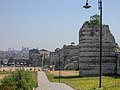
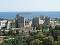
Restored section of the land wall in what is now Istanbul

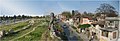
View of today's Istanbul from the land wall
The wall section in the Blachernenviertel with the remains of the Porphyrogennetos Palace in the background

Restored section at the Selymbria gate. In the foreground the front wall and the parapet over the former moat, on the left in the background a tower of the main wall

A section of the wall that has not been restored
Remains of the moat and front wall in the Sulukule district

The peribolos between the main and front wall
The Golden Gate and the Seven Towers Castle, view from 1685
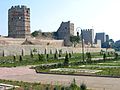
Southern section with the so-called marble tower

The interior of a tower room


Design features
The architecture of the land and sea walls of Constantinople reflects the building tradition of late antiquity. Its depth and complexity made the wall practically impregnable against an enemy who had no artillery. It combined the entire knowledge and experience of the Greco-Roman fortress construction technology and proved itself up to the introduction of heavy firearms in the siege war.
As you approached the city from the Thracian plain, the wall shone bright white in the sunlight from horizon to horizon, as the rising masonry consisted of a shell construction, which, filled with a mixture of rubble and concrete, was encased in a limestone shell. The outside was traversed at regular intervals by horizontal strips of brick, which connected the limestone shell like a box and thus gave it greater strength ( brick penetration ). The centerpiece of the bulwark, however, remained the wall of the Anthemios, which was protected by a particularly resistant u. a. A cast mortar core consisting of crushed pumice stone was held together.


The defenses took up a total of 70 m wide and covered almost the entire west side of the peninsula. Only in the east, at the Blachernenviertel , was it protected by a single wall that was just as huge in its dimensions because of the peculiarities of the terrain there.
The wall system essentially consists of a total of four securing lines arranged in steps:
- The trench lined with bricks, divided into sections by bulkheads and flooded with water, 15 to 20 m wide and 5 to 7 m deep.
- The moat wall (parapet), it was kept very low (2 m) in order to allow unhindered bombardment of the glacis from the walls behind it.
- The front wall was 8 m high and 2.8 m wide, divided with casemates and equipped with 82 towers protruding outwards.
- The main wall reached a height of 12 m, was 5 m wide and equipped with a total of 96 outwardly protruding towers, which were offset from the towers of the front wall and thus also covered these gaps.
The battlements were covered by head-high battlements and were quickly accessible via brick staircases. Between the parapet and the front wall there was an approximately 18 m wide terrace ( parateichion ) from which attackers who had managed to overcome the trench could be effectively shot at. Another terrace ( peribolos ) was located between the inner and front walls, measuring around 15-20 m in width. Calculated from the bottom of the trench to the top of the highest tower, the wall ring reached a height of almost 30 m.
The land wall had only two weak points, which were very dangerous for the defenders: In the middle section, near the deeply cut valley of the Lykos, the walls followed the slope and their towers no longer overlooked the heights. In the event of a siege, they were below the gun level of the attackers who were positioned on the edge of the valley, i.e. H. the attackers could shoot down directly on the walls from here. In addition, a stream ran through a water pipe into the city, so that it was not possible to dig a weir.
The second anomaly was in the Blachernenviertel, at the northern end of the wall. The course of the three wall lines was abruptly interrupted here, as they swung away from the city at right angles to include the church of St. Maria von Blachernae in the defense. After this bulge, the bulwark is transformed over a length of approx. 400 m into a jumbled ensemble of differently constructed fortifications. Under Emperor Manuel I (1143–1180), a new one was built 100 m west of this older wall (Komnenen wall), which was provided with 13 very close together, semicircular towers and also had no defensive moat in front.

Towers
The towers of the main wall measured an average of 11 × 10 m on their base, had a base of 9 to 13 m, were 24 m high, without any strategic foundation either square, hexagonal, octagonal, in some cases also round. They consisted of a storage room on the ground floor, two chambers and a crenellated platform from which one could hurl projectiles or containers with Greek fire at the besiegers with catapults . They were very close to each other (55 m). According to the experience of Roman construction technology, they were not directly connected to the main wall so that both structures could sit independently of each other.
Gates
The wall was broken through at irregular intervals by 12 closely guarded gates. Some were only accessible via wooden bridges, which could be quickly dismantled in the event of a siege. The so-called "army gates" enabled the connection between the various sections of the wall and enabled troops to be moved quickly. In addition, there were also smaller side gates. The army gates were initially only numbered, the public gates were given names.
In this context, for. B. the source gate, which was named after an old spring shrine in the run-up to the city, the gate of the wooden amphitheater, the boot maker gate, or the gate of the Silver Lake. It was opened to the new emperor for his triumphal entry into the city in 1261 after the restoration of the Byzantine Empire. After he was thrown from his horse and seriously injured, the dying Emperor Theodosius II was brought back to the city through Army Gate V. The gate of the wooden amphitheater was walled up in the 12th century, since according to a prophecy Friedrich Barbarossa would otherwise enter the city at this point.
In the course of the centuries they often changed their names as the origin and context of the old naming were forgotten and new references were made. Heerestor III was later referred to as the Gate of the Reds, the color of the clothing of one of the very popular circus parties that rioted in the city especially in late antiquity. The Gate of Charisios, once a leader of the Blue Circus Party, was later known as the cemetery gate.
The most magnificent and largest, however, was the 66 m wide and 20 m high Golden Gate ( porta aurea ) with its three passages, which was at the southern end of the wall complex, almost directly on the shore of the Marmara Sea. Some remains of the Constantinian wall have also been preserved here. In its heyday it was adorned with gold plates and numerous bronze statues and flanked by two massive towers, which were clad with polished marble on the outside. Through this gate z. B. Emperor Heraclios brought the relic of the true cross back to the city in 628 . It was also the end point of the Via Egnatia , the main route through the Balkans to Rome . Most of the decorations had already disappeared by 1453, but at that time it must still have made an impressive impression on the viewer.
- Gates of the country wall

The Golden Gate in its current state

Fragments of statues that once adorned the Golden Gate (Istanbul Archaeological Museum)

The Charisiustor

The source gate (Silivri)

The Heerestor II or Belgrade Gate

Gate of St Romanos


Sea wall

Of the total of 20 km of their fortifications, almost 13 km were on the coast. The troubled Marmara Sea made any attempt to land extremely risky due to the occurrence of strong currents and sudden storms. In the almost 1,000 years of its existence, until the siege of the Crusaders in 1204, no major attack had been dared on the city's coasts. The coast and ports were secured by a single continuous line of walls. It rose about 15 m above the coastline and was secured with 188 towers and three larger fortified harbors. However, it was endangered by the constantly surging waves, which over time repeatedly washed away its foundations. Its entire length was provided with inscriptions on marble slabs, which glorified the various renovation measures carried out by various emperors. To the north of the city was the bay of the Golden Horn in whose calmer waters the ships of the Byzantine fleet were moored. A total of 110 towers secured the sea wall on this section. Numerous smaller gates and the two largest ports in the city were located here. The fortifications on the Golden Horn were nevertheless the greatest weak point in the city wall. Here the Venetians succeeded in penetrating the city during the 4th Crusade by putting their ships on the beach so that the masts towered over the wall and the soldiers could enter the city through them.
The locking chain

In order to effectively block the access to the Golden Horn for enemy ships during a siege, since the siege by the Arabs of 717 the defenders have drawn a massive iron chain approx. 300 m long across the bay. Its limbs were made of wrought iron and about eight inches long. They were carried on the water by wooden rafts. Chain and rafts were kept ready for use even during the winter months. In the late period of Byzantine rule over the city, however, the consent of the Genoese first had to be obtained in order to be able to attach the chain to a tower in Galata .
course

The land wall delimits today's old town in the Fatih district . Until the beginning of the 20th century it marked the city limits of Constantinople - with the exception of Pera . It extends from the western half of the Golden Horn to the Sea of Marmara , where it connects to the sea wall in the east - only preserved in fragments. The wall begins in the north right next to today's motorway bridge over the Golden Horn . The first section dates from the time of Herakleios (627), Leo V (813) and Manuel I Komnenos (1143–1180). The brick and stone Tekfur Palace , a three-storey extension of the Blachernen Palace , the residence of the Byzantine emperors in the 13th and 14th centuries, which was largely demolished after the Ottoman conquest of Constantinople, is located directly on the wall . A little further south, within the walls, is the Chora Church and directly behind the Edirne Gate , the Adrianople Gate of the Byzantines, on the highest point of the old town stands the Mihrimah Camii designed by Sinan , the mosque of Suleyman the Magnificent's favorite daughter . Here the country wall is broken through by a main road ( Fevzi Paşa Caddesi ). After being interrupted by another main road ( Adnan Menderes Caddesi ), the Topkapı Gate (cannon gate ) is located on the third (Millet Caddesi), which was Romanos Gate in Byzantine times . The current Turkish name recalls the conquest of Constantinople by Mehmed Fatih in 1453, when it was badly damaged by the Ottomans after being shot at by 600 kg cannon balls. At the Marmara Sea, the approximately 6.5 kilometer land wall ends at the Mermer Kule fortress (marble tower). Today it is separated by the coastal road. The lower half of this 30 m high tower (with a diameter of 13 meters) is completely covered with marble. Mermer Kule connects the land wall with the sea wall, which extends eastward on the coast to the tip of the peninsula.
Yedikule , the "Castle of the Seven Towers", is located - separated from the Sea of Marmara by the Edirne railway line- directly on the wall and the Golden Gate. The complex is partly Byzantine, partly Ottoman in origin. Its towers are connected to one another by particularly massive walls. It served the Ottomans as a dungeon, treasury and place of execution.
literature
-
The land wall of Constantinople. de Gruyter, Berlin 1938–1943
- Volume 1: Theodor von Lüpke : Drawing restoration with accompanying text by Fritz Krischen . 1938; Reprinted 1974, ISBN 3-11-002238-9 .
- Volume 2: Bruno Meyer-Plath, Alfons Maria Schneider: recording, description and history. 1943; Reprinted 1978, ISBN 3-11-004992-9 .
- Neslihan Asutay-Effenberger: The land wall of Constantinople-İstanbul. Historical-topographical and architectural studies. de Gruyter, Berlin 2007, ISBN 978-3-11-019645-0 (Habilitation FU Berlin 2005, XI, 271 pages, [112] illustrated).
- Roger Crowley : Constantinople 1453. The last battle. 2nd, corrected edition. Konrad Theiss, Stuttgart 2009, ISBN 978-3-8062-2191-6 , pp. 83-99.
- Leslie Brubaker: Topography and the creation of public space in early medieval Constantinople. In: Mayke de Jong, Francis Theuws (Ed.): Topographies of power in the early middle ages (= The Transformation of the Roman World. Vol. 6). Brill, Leiden u. a. 2001, ISBN 90-04-11734-2 , pp. 31-43.
- Paul Hetherington, Werner Forman (illustrations): Byzantium. City of gold, world of faith. Atlantis, Luzern / Herrsching am Ammersee 1987 (original title: Byzantium , translated by Ursula Treu), ISBN 3-7611-0689-0 , p. 56.
- John Julius Norwich : Byzantium. The rise of the Eastern Roman Empire. Econ, Düsseldorf / Munich 1998, ISBN 3-430-17161-X , p. 158.
- Samuel Aldred Slattery: The Politics of the Gate: Byzantine City Walls and the Urban Negotiation of Imperial Authority. Faculty of the Department of History Bates College, Capstone Projects at Scarab, Honors Theses. 109, Lewiston, Maine 2014. PDF
Web links
- 3D reconstruction of the Theodosian Walls at the Byzantium 1200 project
- 3D reconstruction of the Sea Wall at the Byzantium 1200 project
- 3D reconstruction of the Old Golden Gate at the Byzantium 1200 project
- 3D reconstruction of the Golden Gate at the Byzantium 1200 project
- Cross-section of the Theodosian Walls
- Diagram detailing the course of the Land Walls
Individual evidence
- ^ Brubaker 2001.
- ↑ Peter Heather : The fall of the Roman Empire (= Rororo 62665). 2nd Edition. Rowohlt-Taschenbuch-Verlag, Reinbek bei Hamburg 2011, ISBN 978-3-499-62665-4 , p. 358.
- ↑ Alexander Van Millingen: Byzantine Constantinople, the walls of the City and adjoining historical sites with maps, plans and illustrations , London, 1899, p. 47

Old City of Istanbul | Blachernen Palace | Chora Church | Fatih Mosque | Hagia Irene | Hagia Sophia | Hippodrome | Little Hagia Sophia | Şehzade Mosque | Sokollu Mehmed Pasha Mosque | Suleymaniye Mosque | Sultan Ahmed Mosque | Theodosian Country Wall | Topkapı Palace | Valens Aqueduct | Yedikule | Zeyrek mosque