Tinjan
|
Tinjan Antignana |
||
|
||
|
|
||
| Basic data | ||
|---|---|---|
| State : |
|
|
| County : |
|
|
| Area : | 54 km² | |
| Residents : | 1,684 (2011) | |
| Population density : | 31 inhabitants per km² | |
| Telephone code : | (+385) 052 | |
| Postal code : | 52 444 | |
| License plate : | PU | |
| Structure and administration (status: 2013, cf. ) |
||
| Community type : | local community | |
| Mayor : | Goran Hrvatin ( SDP ) | |
| Website : | ||
Tinjan ( Italian Antignana ) is a place in Croatia .

geography
Tinjan is located 21 km east of Poreč / Parenzo and 12 km west of Pazin , directly on the connecting road between the main Istrian tourist resort on the west coast and the central administrative center of the peninsula. The place is located directly above the Dragatal , which extends to the Limfjord , on the coast between Vrsar and Rovinj .
Sights and interesting things
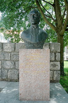
The center of the old district is the parish church of St. Simeon and Jude Thaddäus, built in 1773 and renovated in 1895 . Another special feature is the so-called “Gespantisch” on the edge of the old part of the town, where important business decisions were made. Josip Voltić , lexicographer and linguist who wrote the first Croatian-German-Italian dictionary, is also the son of this community. A memorial not far from the church also commemorates Bishop Juraj Dobrila .
literature
- Istria travel guide; Pula - MARA 2005; Editor Vesna Camdzic; ISBN 953-7001-00-8
- Istria - history, culture, artistic heritage; Travirka Antun; FORUM - Zadar 2006, ISBN 953-179-468-5
- Art-historical travel guide Istria - Cres - Losinj; TRIESTE 2004; Bruno Fachin Editor; ISBN 88-85289-67-3


