Trebnitz (Müncheberg)
|
Trebnitz
City of Müncheberg
Coordinates: 52 ° 31 '54 " N , 14 ° 13' 4" E
|
|
|---|---|
| Height : | 65 m above sea level NHN |
| Area : | 10.46 km² |
| Residents : | 505 (Dec. 31, 2006) |
| Population density : | 48 inhabitants / km² |
| Incorporation : | March 1, 2002 |
| Postal code : | 15374 |
| Area code : | 033477 |
|
Village church
|
|
Trebnitz is a district of the city of Müncheberg in the Märkisch-Oderland district in Brandenburg . Until it was incorporated into Müncheberg on March 1, 2002, Trebnitz was an independent municipality.
location
Trebnitz lies on the edge of the Märkische Schweiz , about halfway between Berlin and the border with Poland . The core town of Müncheberg is around six kilometers and the town of Seelow around eleven kilometers away. The district of Trebnitz borders in the north on Wulkow , in the east on Alt Rosenthal , in the south-east on Worin , in the south on Jahnsfelde , in the south-west on Müncheberg, in the west on Obersdorf and in the north-west on Hermersdorf .
State road 36 runs through Trebnitz, federal road 1 is about two kilometers south of the village. The Trebnitz (Mark) stop is located north of the town center on the Berlin – Küstrin – Kietz border line .
history
Trebnitz was first mentioned in 1224 in a deed of donation from Heinrich the Bearded to the Cistercian monastery Trebnitz (in what is now the Polish city of Trzebnica ). The village is a foundation of the monastery and was named after the Polish city, whose name in turn refers to a clearing settlement. In April 1432 Trebnitz was destroyed by plundering Hussites , during the Thirty Years War Trebnitz was destroyed several times and each time rebuilt.
From 1867 the construction of the Royal Prussian Eastern Railway took place in Trebnitz , which, together with the coal mining operated in the region at that time, brought about an economic upswing for the village. Towards the end of the Second World War , Trebnitz was largely destroyed by the advancing Red Army during the offensive on Berlin in April 1945 . After the end of the war and the reconstruction of the place, the number of inhabitants in Trebnitz grew strongly due to the influx of around 550 refugees from the eastern German regions. Land reform in the Soviet occupation zone was also carried out in Trebnitz in 1946 .
In 1951 the "machine and tractor station" was built in Trebnitz, which later became the "district operation for agricultural technology". After the district reform in the GDR, the municipality of Trebnitz belonged to the Seelow district in the Frankfurt (Oder) district from July 25, 1952 . In 1956 an agricultural production cooperative was founded . After the reunification , the district of Seelow was renamed the district of Seelow and as a result of the district reform in Brandenburg on December 6, 1993 with the districts of Strausberg and Bad Freienwalde to the district of Märkisch-Oderland .
After an official resolution of February 13, 2002, the Trebnitz community was dissolved with effect from March 1, 2002 and incorporated into Müncheberg.
Attractions
- Trebnitz village church , neo-Gothic hall church, was rebuilt between 1660 and 1671 on the initiative of the Brandenburg Lieutenant General Joachim Ernst von Görzke after the previous church was destroyed in the Thirty Years War. The previous building was destroyed by the Hussites in 1432. The church was massively damaged in the Second World War.
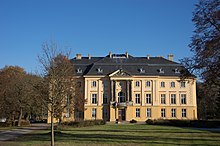
- Trebnitz Castle
- Castle Park. Created around 1730 by Johann Gottlieb Gleditzsch and redesigned as a landscape park in the mid-19th century by Peter Josef Lenné and Eduard Neide .
Web links
Individual evidence
- ↑ Reinhard E. Fischer : The place names of the states of Brandenburg and Berlin. Age - origin - meaning. be.bra Wissenschaft Verlag, Berlin 2005, p. 170.
- ^ History of the place Trebnitz. In: schloss-trebnitz.de , accessed on November 11, 2019.
- ^ Georg Dehio: Handbook of German Art Monuments. Brandenburg. Deutscher Kunstverlag GmbH Munich Berlin, 2000

