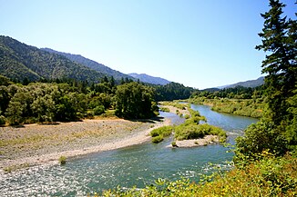
Trinity River (California)
| Trinity River | ||
| Data | ||
| Water code | US : 236551 | |
| location | California (USA) | |
| River system | Klamath River | |
| Drain over | Klamath River → Pacific Ocean | |
| source | in the Scott Mountains , Trinity County 41 ° 19 ′ 53 ″ N , 122 ° 33 ′ 9 ″ W |
|
| Source height | 1693 m | |
| muzzle | in the Klamath River near Weitchpec Coordinates: 41 ° 11 '5 " N , 123 ° 42' 31" W 41 ° 11 '5 " N , 123 ° 42' 31" W |
|
| Mouth height | 58 m | |
| Height difference | 1635 m | |
| Bottom slope | 7 ‰ | |
| length | 232 km | |
| Catchment area | 7390 km² | |
| Discharge at the Hoopa A Eo gauge : 7386 km² |
MQ 1964/2016 Mq 1964/2016 |
135 m³ / s 18.3 l / (s km²) |
| Left tributaries | South Fork Trinity River | |
| Right tributaries | Stuart Fork Trinity River, North Fork Trinity River, New River | |
| Reservoirs flowed through | Trinity Lake , Lewiston Lake | |
| National Wild and Scenic River | ||
|
Trinity River near Hoopa |
||
|
Trinity River near Weaverville |
||
The Trinity River is a left tributary of the Klamath River in the north of the US state of California .
It has its source near the ridge in the south of the Klamath Mountains and originally flowed westwards towards the Pacific Ocean . Since the construction of the Trinity Dam in 1962, the river to the Trinity Lake reservoir has been dammed and used to generate energy. Below the power station, the river is dammed again in the smaller Lewiston Lake and around 90% of the water volume is diverted from there via a canal and tunnel system west to the Sacramento River . This structure is part of the Central Valley Project and is used to irrigate California's long valley to irrigate the agricultural land. The remaining 10% of the original water continues to flow as the Trinity River and flows after 232 km into the Klamath River, whose largest tributary is the Trinity River.
Gold was found and exploited on the upper reaches of the Trinity River during the California gold rush in 1849 . The Trinity River is rich in fish, including the rare king salmon and steelhead trout , which spawn as so-called anadromous migratory fish in freshwater, but live in the ocean for most of their lives.
Today the river is a popular area for canoeing , in the upper sections for whitewater paddling , and on the lower reaches of water hiking . In 1981 the Trinity River below Lewiston Lake was designated as a National Wild and Scenic River and thus protected from further construction .
The last 20 kilometers of the river and its mouth are in the reservation of the Hoopa Indians.
Web links
- National Park Service: Trinity River (official site; English)
Individual evidence
- ↑ a b c Trinity River in the Geographic Names Information System of the United States Geological Survey
- ^ Water Resources Data - California, Water year 2004, Volume 2 , USGS ; Pages 414-415, Level 11530000 Trinity River at Hoopa, CA.
- ↑ USGS 11530000 TRINITY RA HOOPA CA.
- ^ Trinity River, California . National Wild and Scenic Rivers System. Retrieved August 15, 2017.


