Tromjogan
|
Tromjogan Тромъёган |
||
|
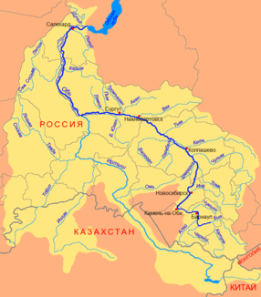
Course of the Tromjogan (Тромъёган) in the catchment area of the Ob |
||
| Data | ||
| Water code | RU : 13011100112115200042143 | |
| location | Khanty and Mansi Autonomous Okrug / Ugra ( Russia ) | |
| River system | If | |
| Drain over | Whether → Arctic Ocean | |
| source |
West Siberian Lowlands 63 ° 12 ′ 22 ″ N , 71 ° 49 ′ 5 ″ E |
|
| Source height | 139 m | |
| muzzle | in the Ob coordinates: 61 ° 13 '18 " N , 73 ° 41' 57" E 61 ° 13 '18 " N , 73 ° 41' 57" E |
|
| Mouth height | 27 m | |
| Height difference | 112 m | |
| Bottom slope | 0.19 ‰ | |
| length | 581 km | |
| Catchment area | 55,600 km² | |
| Discharge at the Kochevye A Eo gauge : 5860 km² Location: 341 km above the estuary |
MQ 1966/1990 Mq 1966/1990 |
58 m³ / s 9.9 l / (s km²) |
| Discharge at the Russkinskie A Eo gauge : 8800 km² Location: 267 km above the mouth |
MQ 1974/1998 Mq 1974/1998 |
83 m³ / s 9.4 l / (s km²) |
| Discharge at the Yermakowo A Eo gauge : 13,500 km² Location: 160 km above the mouth |
MQ 1955/1987 Mq 1955/1987 |
113 m³ / s 8.4 l / (s km²) |
| Discharge at the gauge near the mouth |
MQ |
425 m³ / s |
| Left tributaries | Njatlongajagun, Entl-Imijagun, Ingujagun, Agan | |
| Navigable | 235 km | |
|
Tromjogan |
||
The 581 km long Tromjogan ( Russian Тромъёган ; also Tromjegan , Trom-Jugan ) is a right tributary of the Ob in Western Siberia ( Russia ).
course
The Tromjogan flows from the small lake Torymjawintyjlor ( Торымявинтыйлор ; also Jachomolto, Jagmot-To), located in the north of the Autonomous Region , at a height of 139 m on the Siberian Ridge (Sibirskije Uwaly), which runs through the West Siberian lowlands in a west-east direction and Mansen / Ugra near the border with the Yamal-Nenets Autonomous Okrug . The river flows through the swampy and extremely lake-rich lowlands in a predominantly south to south-east direction, whereby it mostly meanders strongly .
At the confluence of the most important, left tributary Agan - others are Njatlongajagun ( Нятлонгаягун ), Entl-Imijagun ( Энтль-Имиягун ) and Ingujagun ( Ингуягун ), all of them from the left - the river turns a little later the Obarm-arm to the southwest (also Ust-Lagar). From here, the Tromjogan follows the main arm of the Ob for almost 50 kilometers at a distance of 5 to 10 kilometers and finally flows into its side arm Sanin , about 15 kilometers east of the city of Surgut .
In its lower reaches, the Tromjogan is in places over 300 m wide and over 2 m deep; the flow velocity is 0.5 m / s.
Hydrography
The catchment area covers 55,600 km². In the vicinity of the mouth the average flow rate is 425 m³ / s, at the village of Yermakowo 160 km above the mouth and above the confluence of the Agan, 113 m³ / s with a minimum of 31.8 m³ / s in March and a maximum of 362 m³ / s in June.
The Tromjogan freezes between October / early November and May.
Economy and Infrastructure
The Tromjogan is navigable from the village of Russkinskaya. As an inland waterway , it is 235 kilometers up to the confluence of the Ob tributary Lagarma; the waterway continues on the main arm of the Ob instead of the Tromjogan.
Practically the entire catchment area of the Tromjogan lies in the area of the West Siberian oil and natural gas deposits , and is therefore developed by (mostly unpaved) roads that serve to explore and extract these raw materials. However, there are no larger places directly on the river. At the Trom-Agan settlement, the highway and railway line Tyumen –Surgut – Novy Urengoy cross the river, a little further southeast, above the confluence of the Agan, the road and railway line to Nizhnevartovsk .
Individual evidence
- ↑ a b c Article Tromjogan in the Great Soviet Encyclopedia (BSE) , 3rd edition 1969–1978 (Russian)
- ↑ a b Tromjogan in the State Water Register of the Russian Federation (Russian)
- ↑ Tromjogan at the Kochevye gauge - hydrographic data from R-ArcticNET
- ↑ Tromjogan at the Russkinskie gauge - hydrographic data from R-ArcticNET
- ↑ a b Tromjogan at the Yermakowo gauge - hydrographic data at R-ArcticNET
- ↑ List of Inland Waterways of the Russian Federation (confirmed by Order No. 1800 of the Government of the Russian Federation of December 19, 2002)

