
Tuim
| Village
Tuim
Туим
|
||||||||||||||||||||||||||||||
|
||||||||||||||||||||||||||||||
|
||||||||||||||||||||||||||||||


Tuim ( Russian Туи́м ) is a village (selo) in the Republic of Khakassia ( Russia ) with 4211 inhabitants (as of October 14, 2010).
geography
The place is about 120 km as the crow flies northwest of the republic capital Abakan at the eastern foot of the Kuznetsk Alatau, which is almost 1400 m high (summit of Bjuja almost 20 km south) . It is located on the upper reaches of the Tuim River , which flows 35 km to the north into Lake Beljo , which has no outflow .
Tuim belongs to the Schirinsky Rajon and is a good 15 km south of its administrative seat Shira . It is the seat of the rural community Tuimskoje selskoje posselenije, to which, in addition to Tuim, the settlements Ulen, Tissin and Verkhny Tuim belong.
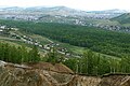
Look at Tuim from Tuimski ProWal from

railway station

Ruins of former industrial plants
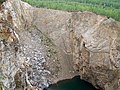
Pinge Tuimski prowal


history
The place was founded in 1925 in connection with the construction of the Achinsk - Abakan railway line and the subsequent development of tungsten , copper and molybdenum ore deposits in the area. After the peak in the 1950s, ore mining gradually declined and was completely discontinued in the 1990s; as a result, the ore enrichment factory was also closed. From 1945 to 2008 Tuim had urban-type settlement status .
Population development
| year | Residents |
|---|---|
| 1959 | 9316 |
| 1970 | 5051 |
| 1979 | 5237 |
| 1989 | 5934 |
| 2002 | 4738 |
| 2010 | 4211 |
Note: census data
Attractions
In place of one of the shafts that had been closed in 1954, a ping called Tuimski prowal was built in the 1970s . The collapse funnel is still unstable, currently has a diameter of 200 m and is filled with water at the bottom. The depth to the water level is 120 m. The ProWal Tuimski is a regionally renowned destination, including for Base and Bungee jumpers and divers.
traffic
A few kilometers north of Tuim is the station of the same name at 275 km of the Achinsk - Abakan line, which was opened in 1926. There is a road connection to the district center of Shira and from there along the railway line to the north in the direction of Ushur and to the 60 km east-running M54 Krasnoyarsk - Abakan - Kyzyl - Mongolian border.
Individual evidence
- ↑ a b Itogi Vserossijskoj perepisi naselenija 2010 goda. Tom 1. Čislennostʹ i razmeščenie naselenija (Results of the All-Russian Census 2010. Volume 1. Number and distribution of the population). Tables 5 , pp. 12-209; 11 , pp. 312–979 (download from the website of the Federal Service for State Statistics of the Russian Federation)