Tully Lake
| Tully Lake Tully Dam |
|||||||||
|---|---|---|---|---|---|---|---|---|---|
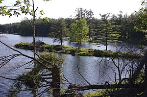
| The lake seen from the campsite | |||||||||
|
|||||||||
|
|
|||||||||
| Coordinates | 42 ° 38 '41 " N , 72 ° 12' 56" W | ||||||||
| Data on the structure | |||||||||
| Construction time: | 1947-1949 | ||||||||
| Operator: | United States Army Corps of Engineers | ||||||||
| Data on the reservoir | |||||||||
| Altitude (at congestion destination ) | 202 m | ||||||||
| Water surface | 5.1 km² | ||||||||
| Maximum depth | 10.36 m (mean depth 3 m) | ||||||||
| Total storage space : | 25th 000 000 m³ | ||||||||
| Particularities: |
Part of the Connecticut River flood control system |
||||||||
The Tully Lake is a reservoir in the area of the city Royalston in the state of Massachusetts of the United States . It was built in the middle of the 20th century by the United States Army Corps of Engineers (USACE) and is mainly used to contain flooding during heavy rainfall, but is also used for leisure and recreational purposes.
Function of the flood control
The 1,262 acres (5.1 square kilometers ) area of comprehensive lake was as part of the system for flood control of the Connecticut River designed and 1947-1949 for a total of 1.6 million US dollars (equivalent to a present value of about 18,280 .000 dollars). Even before its final completion, it was successfully used to limit the New Years flood of 1949.
In April 1987, a good 6 in (152.4 mm ) of precipitation fell during two storms , causing the lake level to rise to more than 35 ft (10.7 m ) at the dam. Despite this large amount of rain, the lake was only 62% full at that time. USACE estimates that in this instance alone, the lake has prevented damage amounting to $ 3 million, or $ 25.6 million since it was opened.
Flora and fauna
The management of the lake and its surroundings is designed to ensure and maintain a healthy ecosystem and the great biodiversity of the Tully River Valley with its forests, wetlands, bodies of water and wildlife. Nearby attractions, managed as protected areas by The Trustees of Reservations , such as Doane's Falls , Spirit Falls and Royalston Falls and Jacobs Hill regularly attract visitors and tourists and are connected by marked hiking trails.
In addition to the trustees, the Division of Fisheries and Wildlife of the Massachusetts Executive Office of Energy and Environmental Affairs is also working on this , which, for example, carries out targeted tree felling in order to make space for young forest on which certain animal species - in particular yellow-throats , cat thrushes , songbugs , Yellow-headed wood warbler and gold wood warbler - for the search for protection, the breeding or rearing of young animals. For these reasons, an 11-acre stand of Weymouth pines south of the lake was cleared.
Although the dam of the lake was completed in 1949, today's Tully Lake was not built until 1966 and has since offered anglers the opportunity to catch largemouth bass , chain pike , American perch , sunfish , catfish and bream . A large variety of different animal species live around the lake, ranging from small insects and songbirds to large mammals such as red deer and elk . Although the reservoir can flood an area of 1,140 acres (4.6 km²) at full capacity, it normally serves as a habitat for wild animals and a public recreational area.
54% of the area of the lake is made up of wetlands that are home to fish, waterfowl , songbirds, insects, reptiles, amphibians and mammals such as beavers , otters and mink . In the other areas mainly red deer, coyotes , fishing marten , owls , foxes , raccoons , skunks , porcupines , rabbits and squirrels live . The forest around the lake consists mainly of Weymouth pine, which grew in fields abandoned in the 19th century.
More than 700 acres (2.8 km²) of the wetlands are also used to clean the water of toxins and sediments and to slow down or attenuate floods. In an isolated kettle hole near the Tully Lake is a spruce - bog . In addition to cranberries , sundew and other carnivorous plants grow in the flood relief areas .
In the vicinity of the reservoir, foundation walls and other remains of houses, mills or a church can still be found, which give evidence of the former use of this area as agricultural and industrial land. The signposted “An Ordinary Story” hiking trail leads past some of these ruins from the parking lot.
freetime and recreation
The lake and its surroundings offer ideal conditions for extensive and extensive activities. There is a 4 mi (6.4 km ) hiking trail around the lake , which is part of the 22 mi (35.4 km) significantly longer Tully Trail and connects Doane's Falls to the lake. The Tully Trail connects a variety of attractions with the Trustees of Reservations The Ledges , Jacobs Hill and Royalston Falls , the Royalston State Forest and Warwick State Forest, and Tully Mountain .
Sports
A separate 7.5 mi (12.1 km) long path is available for mountain bikers , which also offers special scenic impressions, but is very demanding and therefore not suitable for beginners.
The lake can be explored with canoes , kayaks or even with small motor boats (max. 10 HP), which can also be rented on site if required. A disc golf facility has been available since 2003 and was expanded to 18 holes in 2006. On the lake is fishing , in the area of the lake and the hunting permits. Appropriate licenses may have to be acquired for this.
There is no designated area for swimmers in the lake, but swimming is expressly permitted. Also in winter there are a variety of leisure activities around the lake.
Tully Lake Campground
The Tully Lake Campground is a campground near the lake. It is owned by the USACE but is administered by the Trustees of Reservations. It is open daily between Memorial Day and Labor Day , and on weekends until Columbus Day .
See also
Individual evidence
- ↑ a b c d e f g h Tully Lake. United States Army Corps of Engineers , accessed December 19, 2013 .
- ^ Massachusetts Fishing, Hunting & Trapping License Types and Fees. Massachusetts Executive Office of Energy and Environmental Affairs, 2013, accessed December 19, 2013 .
Web links
- Tully Lake in the Geographic Names Information System of the United States Geological Survey
- Tully Lake Park Map. ( PDF ) United States Army Corps of Engineers , 2013, accessed December 19, 2013 (English, map of the park).
- Tully Lake Depth Map. ( PDF ) United States Army Corps of Engineers , 2013, accessed December 19, 2013 (English, depth map of the lake).
- Tully Lake Campground - Campground website
- Tully Lake Campground on TripAdvisor
- Map of the campsite

