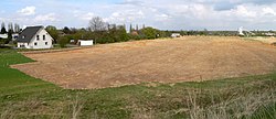
Rüningen urn grave field
Coordinates: 52 ° 12 ′ 36 ″ N , 10 ° 29 ′ 42 ″ E
| Rüningen urn grave field | ||
|---|---|---|
|
Archaeological investigation area in the area of the urn grave field Rüningen, 2015 |
||
| location | Lower Saxony , Germany | |
| Location | Rüningen | |
|
|
||
| When | late Roman Empire , late 3rd century to early 7th century |
|
| Where | Rüningen , Braunschweig / Lower Saxony | |
|
Excavation section, 2015 |
||
The urn grave field Rüningen is an archaeological site in the Brunswick district of Rüningen in Lower Saxony . It is a Germanic burial ground from the late Roman Empire , which was covered with urns from the late 3rd to the 7th century . The size of the cemetery, which has not yet been completely archaeologically investigated, is estimated to be 13 hectares with around 4500 burials , making it the largest facility of this period in the Braunschweig region . The excavations have been carried out since 2005.
description
The burial ground is located south of Rüningen and northwest of Leiferde on areas previously used for agriculture. It is bounded by the A 39 , the B 248 , a district road and an industrial park . In the south, the burial ground found its natural limit through the valley of the Thiedebach . Its northern extent is not known, since there is a development by the industrial park.
The existence of a burial ground in the area has been known since at least 1928, when about 70 prehistoric urns were first excavated. In 2003 a farmer again came across fragments of clay pots while plowing his field. A local curator who was brought in identified them as early historical ceramics . The district archeology of Braunschweig of the Lower Saxony State Office for the Preservation of Monuments carried out the first large-scale archaeological investigation of the burial ground in 2005. It was necessary because the remains of the soil were threatened with destruction by the construction of a junction for the A 39 and the establishment of a roundabout. 110 urn burials were recovered. Since an industrial area is planned on other arable land, the archaeological investigations there have been continued since 2008. The investigation is expected to be completed in 2015.
During the excavations so far (2015) around 3800 burials have been found. In the west of the burial ground there were around 30 places with charcoal-like remains in the ground, which could be identified as earlier pyres used to cremate the deceased. According to the reconstruction of the archaeological was cremated collected after combustion of the stake out and filled in a box, which was placed in a hole in the ground between 40 and 60 cm depth. Only in a few cases were there any additions or remains of the burnt equipment of the deceased in the urns. In individual cases, these were combs and game pieces made of bones and pieces of glass that had melted from the burn. There were hardly any metal objects, such as rivets , in the urns. An exception is an arrowhead made of sheet bronze, which did not show any traces of fire and was subsequently placed in an urn.
The oldest urns are carefully crafted and decorated bowl urns around 30 cm in diameter. Other urn shapes are vessels with a standing ring and pot-shaped urns as well as bowls . There were also awkward urns that were badly burned. The quality of the vessels decreased over time. In some of the urn burials, archaeologists suspect poor material quality or self-dissolving vessels, e.g. made of wood or fabric.
It was noticeable that the burials that had lasted over 400 years did not overlap. This suggests permanent grave markings above ground. The archaeologists were able to identify flat mounds of earth around which the urns were arranged in a circle.
rating
The archaeologists suspect that the burial ground was the central cemetery of a population who lived in small groups of homesteads in the area south of today's city of Braunschweig. With the assumed 6000 burials in around 400 years, there were arithmetically around 15 deaths annually. Calculations showed that this corresponds to a population of around 500 to 1000 people living at the same time.
On the part of the Lower Saxony State Office for the Preservation of Monuments, there was a high level of scientific interest in fully investigating the burial ground because it represents a historical testimony of national importance. In the Braunschweig region it is not only the largest facility discovered to date, but also the last largely preserved Germanic burial ground. Many other sites have been destroyed by agriculture, especially the deep asparagus cultivation .
literature
- Jörg Weber: "Long live the central cemetery ..." Investigations on a Germanic fire burial ground in the south of the city of Braunschweig. In: Archeology in Lower Saxony . 12. Oldenburg 2009, pp. 59-62, ISSN 1615-7265 .
Web links
- Teutons settled in the south of the city in: neue Braunschweiger from June 30, 2005, p. 20 (PDF, 3.9 MB)
- Short description for Heritage Day 2008
- Zoning plan with design regulation Braunstraße-Süd dated January 2, 2009 (PDF; 155 kB), p. 16
Individual evidence
- ↑ Lothar Jungeblut: Graves, stolen swords and “magical” runes . (PDF) pp. 5, 6
- ↑ Jörg Weber: "Long live the central cemetery ..." In: Archeology in Lower Saxony. 2009 pp. 59–62.
- ↑ Development plan with design regulations Braunstraße-Süd ( Memento of the original from March 6, 2016 in the Internet Archive ) Info: The archive link was inserted automatically and has not yet been checked. Please check the original and archive link according to the instructions and then remove this notice. of January 2, 2009 (PDF; 155 kB), p. 16


