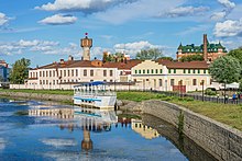
Uvod
|
Uvod Уводь |
||
|
The flood leading to Uvod near Kovrov |
||
| Data | ||
| Water code | RU : 09010301012110000032970 | |
| location | Ivanovo , Vladimir Oblast ( Russia ) | |
| River system | Volga | |
| Drain over | Klyazma → Oka → Volga → Caspian Sea | |
| source | around 15 km northeast of Komsomolsk 57 ° 6 ′ 48 ″ N , 40 ° 30 ′ 28 ″ E |
|
| muzzle | about 10 km northeast of Kowrow in the Klyazma coordinates: 56 ° 25 ′ 11 " N , 41 ° 26 ′ 27" E 56 ° 25 ′ 11 " N , 41 ° 26 ′ 27" E
|
|
| length | 185 km | |
| Catchment area | 3770 km² | |
| Outflow location: 30 km above the mouth |
MQ |
19 m³ / s |
| Left tributaries | Uroschna , Talka | |
| Right tributaries | Vostra , Uchtochma , Vjasma , Talsha , Naromsha | |
| Reservoirs flowed through | Uvod reservoir | |
| Big cities | Ivanovo , Kovrov | |
| Medium-sized cities | Kochma | |
|
Location of the Uvod (Уводь) in the catchment area of the Oka |
||
The Uvod ( Russian Уводь ) is a 185 km long left tributary of the Klyasma in the European part of Russia .
course
The Uwod rises in a swamp area not far from the village of Piszowo in the western Ivanovo Oblast . From there it flows eastwards through hilly, swampy terrain, before it flows into the Uwod Reservoir ( Uwodskoje Vodochranilishche, Russian Уводьское водохранилище ) after just a few kilometers . The 37 km long reservoir , built in 1937, is on average 1.5 km wide and 15 m deep. Its main purpose is to supply the city of Ivanovo with water . Since the water from the Uvod could not cover the city's consumption, a canal from the Volga to the Uvod was opened in 1967.
The river leaves the reservoir at its southern end, right on the border of the urban area of Ivanovo. It flows through the city and picks up the Talka and the Charinka. Immediately southeast of Ivanovo flows through the Uwod Kochma , a satellite town of Ivanovo. Below the city, it turns to the south, where its two main tributaries, the 89 km long Uchtochma and the 86 km long Vyazma, flow at a distance of only 12 km. The river flows through a wooded, rugged valley here and deposits sand on its banks due to the reduced flow speed. It forms numerous oxbow lakes and begins to meander more and more .
The Uvod reaches the Vladimir Oblast about 10 km northwest of Kovrov . Here it grows wild . It passes the city a little north of the urban area and finally flows into the Kljasma a few kilometers later.
Hydrology and use
The Uwod is mainly fed by snowmelt water. It is frozen on average from November to April. Of its tributaries, 14 are longer than 10 km. The Uwod has an average gradient of 0.198 m / km.
The textile industry , which has been settled in Ivanovo since the times of Peter the Great , used the Uwod both as a source for service water and to dispose of the waste water produced. This led to so much pollution that in the river, which in earlier times was known for its abundance of fish and whose water had been used as drinking water , hardly any fish lived by the end of the 19th century, and people were forced to flow along its course To drill drinking water wells.
Web links
Individual evidence
- ↑ a b c d Article Uwod in the Great Soviet Encyclopedia (BSE) , 3rd edition 1969–1978 (Russian)
- ↑ a b Uvod in the State Water Directory of the Russian Federation (Russian)
- ↑ a b c d Tourist encyclopedia of waters: tributaries of the Kljasma ( Memento of the original from March 1, 2002 in the Internet Archive ) Info: The archive link has been inserted automatically and has not yet been checked. Please check the original and archive link according to the instructions and then remove this notice. , Description of the Uwod (Russian)
- ↑ a b Uwod on aquaexpert.ru (russ.)
- ↑ a b Description of the Uwod on svyato.info (Russian)
- ↑ Uwod in Brockhaus-Efron - Encyclopedic Dictionary , quoted in the Russian online encyclopedia Академик / Akademik (russ.)


