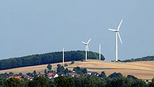
Vörier mountain
| Vörier mountain | ||
|---|---|---|
|
Vörier Berg from the north-west |
||
| height | 148 m above sea level NHN | |
| location | at Holtensen ; Region Hannover , Lower Saxony ( Germany ) | |
| Dominance | 0.62 km → Süllberg | |
| Notch height | 6 m | |
| Coordinates | 52 ° 15 '44 " N , 9 ° 39' 3" E | |
|
|
||
The Vörier Berg is 148 m above sea level. NHN high foothills of the Wolfsberg ( 153 m ) in the Calenberger Land . It is located near Holtensen in the Hanover region of Lower Saxony and originated in the Jura .
geography
location
The Vörier Berg rises in the area of the municipality of Wennigsen , whose district Holtensen is 1000 m west-northwest of the summit. It is a neighbor of Wolfsberg, 1.2 km southeast in Lüdersen , a foothill of the Süllberg ( 199 m ). Between the latter and the Vörier Berg flows coming from Lüdersen Bach reason , in the west of both surveys and Holtensen to Ihme extending Holtenser Bach (Holtenser Beeke) opens. 2.2 km north is Vörie and 1.7 km north-northeast is Linderte , two districts of Ronnenberg .
Natural allocation
The Vörier Berg belongs to the natural spatial main unit group Lower Saxony Börden (No. 52), in the main unit Calenberger Lößbörde (521) and in the subunit Hannoversche Börde (521.0) to the natural area Gehrdener Loesshügel (521.01).
Nature and landscape protection
On the northern flank of the Vörier Mountain, a grove of birch and spruce stands right up to the summit. Parts of the landscape protection area (LSG) Landwehr-Süllberg ( CDDA no. 322484; designated 1968; 15.718 km² in size) lie on the elevation and parts of the LSG Süd-Deister (CDDA no. 324904; 1967; 33.792 km² ) on the transition area to Wolfsberg ). The former with the No. H-22 of the Hanover region is currently being revised. After a political decision it should become part of the Norddeister (H-23). The need for protection is based, among other things, on the centrally located part of the Calenberger Lößbörde natural area.
The course of the Grund brook flowing between Vörier Berg and Süllberg was renatured in the 1980s as a large-scale ecological compensation measure by the then district of Hanover .
Infrastructure
Residential area and wind turbine
The Vörier Berg residential area has existed in Holtensen since 2005, to which the second construction phase was added in 2012. In the eastern part of the village it borders on the Osterfeld residential area that was built in the 1960s. The latter is considered an attractive residential area in the Wennigsen community due to its hillside location on the elevation. On the top of the elevation was one of the first wind turbines built in inland Germany. The three Enercon E-32 turbines built at the end of the 1980s were replaced by a 1.3 MW AN Bonus turbine that went into operation in 2000 .
Transport links

To the west past the Vörier Berg runs through Holtensen the federal road 217 , from which one can drive on local roads to the elevation. This can then be reached via the Lüderser Weg field path, which leads from the village to Lüdersen and emerges from the local edge road of the same name , which is closed to public motor vehicle traffic and turns into the residential street Holtenser Weg in Lüdersen . The Hanover – Altenbeken railway with the nearby Holtensen / Linderte and Bennigsen stops runs northeast past the elevation .
Individual evidence
- ↑ a b Topographic map with the Vörier Berg ( Memento of the original from March 4, 2016 in the Internet Archive ) Info: The archive link was inserted automatically and has not yet been checked. Please check the original and archive link according to the instructions and then remove this notice. (for mountain height see DTK 50), on natur-erleben.niedersachsen.de
- ^ Sofie Meisel: Geographical land survey: The natural space units on sheet 86 Hanover. Federal Institute for Regional Studies, Bad Godesberg 1962. → Online map (PDF; 4.0 MB)
- ↑ Map services of the Federal Agency for Nature Conservation ( information )
- ↑ LSG-H 22 - Landwehr-Süllberg. Reference: Nds. Ministerialblatt No. 39/1968 of September 16, 1968, p. 981 (PDF; 41 kB). hannover.de, accessed on January 9, 2016 .
- ↑ Mayor's article : "We build landscape-friendly" ( Memento from June 29, 2013 in the Internet Archive ) (CON report from May 23, 2012), on archive.org
- ↑ Database of wind energy use in the Hanover region ( memento of the original from January 15, 2017 in the Internet Archive ) Info: The archive link has been inserted automatically and has not yet been checked. Please check the original and archive link according to the instructions and then remove this notice. , accessed on January 15, 2017, on klimaschutz-hannover.de (PDF; 121 kB)


