
Administrative community Neustadt an der Waldnaab
| coat of arms | Germany map | |
|---|---|---|
 Help on coat of arms |
Coordinates: 49 ° 44 ' N , 12 ° 10' E |
|
| Basic data | ||
| Existing period: | 1973– | |
| State : | Bavaria | |
| Administrative region : | Upper Palatinate | |
| County : | Neustadt an der Waldnaab | |
| Area : | 127.68 km 2 | |
| Residents: | 7514 (Dec 31, 2019) | |
| Population density : | 59 inhabitants per km 2 | |
| License plate : | NEW, ESB , VOH | |
| Association key : | 09 3 74 5323 | |
| Association structure: | 5 municipalities | |
| Association administration address : |
Freyung 17 92660 Neustadt adWaldnaab |
|
| Website : | ||
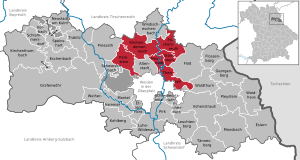
| Location of the Neustadt an der Waldnaab administrative community in the Neustadt an der Waldnaab district | ||
  |
||

The administrative community Neustadt an der Waldnaab (VGem) is located in the Upper Palatinate district of Neustadt an der Waldnaab and is formed by the following communities:
- Kirchendemenreuth , 858 inhabitants, 39.31 km²
- Parkstein , market , 2318 inhabitants, 30.85 km²
- Püchersreuth , 1640 inhabitants, 25.21 km²
- Störnstein , 1510 inhabitants, 10.92 km²
- Theisseil , population 1188, 21.4 km²
The administrative association's office also administers the Parkstein school association.
The administrative community is based in Neustadt an der Waldnaab .
The Neustädter Verwaltungsungsgemeinschaft (a corporation under public law) emerged on July 1, 1973 from the municipal reform in Bavaria. It was the first "working" administrative association in Bavaria and is the second largest local authority in the district after the city of Vohenstrauss .
The city of Neustadt adWaldnaab itself does not belong to this administrative community.
Individual evidence
- ↑ "Data 2" sheet, Statistical Report A1200C 202041 Population of the municipalities, districts and administrative districts 1st quarter 2020 (population based on the 2011 census) ( help ).
- ↑ The administrative association Hörnergruppe was founded by ordinance with effect from April 1, 1973.
Web links
Eschenbach idOPf. | Kirchenthumbach | Neustadt adWaldnaab | Pleystein | Pressath | Umbrella seat | Tännesberg | Weiherhammer
Resolved: raft