
Vidraru
| Vidraru | |||||||||
|---|---|---|---|---|---|---|---|---|---|
 |
|||||||||
|
|||||||||
|
|||||||||
| Coordinates | 45 ° 22 ′ 0 ″ N , 24 ° 37 ′ 50 ″ E | ||||||||
| Data on the structure | |||||||||
| Construction time: | 1961-1966 | ||||||||
| Height of the barrier structure : | 166.60 m | ||||||||
| Height above valley floor: | 668 m above sea level NN | ||||||||
| Height of the structure crown: | 834.00 m above sea level NN | ||||||||
| Building volume: | 0.48 million m³ | ||||||||
| Crown length: | 307 m | ||||||||
| Crown width: | 6 m | ||||||||
| Base width: | 25 m | ||||||||
| Power plant output: | 220 MW | ||||||||
| Data on the reservoir | |||||||||
| Altitude (at congestion destination ) | 830 m above sea level NN | ||||||||
| Water surface | 8.93 km² | ||||||||
| Reservoir length | 10.3 km | ||||||||
| Reservoir width | 2.2 km | ||||||||
| Storage space | 465 million m³ | ||||||||
| Catchment area | 286 km² | ||||||||
| Design flood : | 660 m³ / s | ||||||||
 |
|||||||||
 |
|||||||||

The Vidraru Dam ( Romanian Barajul Vidraru ) is a dam in the Argeș County in the historic Wallachia (Țara Românească) region in Romania .
Geographical location
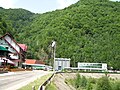
The Vidraru Dam is located north of the historical region of Great Wallachia (Muntenia) on the upper reaches of the Argeș . In the form of an arch dam between the Frunții and Ghițu mountain ranges of the Transylvanian Alps (Carpații Meridionali) , the dam is about 30 kilometers north of the small town of Curtea de Argeș and is used to generate electricity . Which is bundled with Vidraru hydroelectric power plant is located two kilometers north of the village Căpăţânenii Ungureni the community Arefu . The Transfogarascher Hochstrasse (Drumul Transfăgărășan) , which is part of the national road (drum național) DN 7C, runs on the dam .
history
In 1961, the construction of the dam and at the same time also the hydroelectric power plant 104 meters below the river bed began. When the dam was built, the Argeș was guided past the structure in a 5.20 meter tube - today at the bottom of the dam. The reservoir was dammed for the first time in December 1965. According to a press article in the Scânteia newspaper , the dam was put into operation on March 15, 1966; the then Minister of Electricity, Emil Drăgănescu , was also present. The same newspaper wrote a year earlier that the mining work for the water supply to the future hydropower plant was completed forty days before the completion date.
According to statements made by some locals from the area, the village of Cumpăna , a former forest workers' village from k. Was in the Argeș valley above today's dam . u. k. Times (which is not included in a general map of Central Europe around 1918) with Vila Verde - the administrative building of the forest enterprise at that time -, the holiday home of the Brătianu family and a narrow-gauge railway that had its terminus here. In addition, the town of Tunel , a cemetery with German soldiers and a hut by the painter Rudolf Schweitzer-Cumpăna are said to have been flooded with the reservoir .
At the time of its completion (1966), the Vidraru Dam was the fifth largest structure of its kind in Europe and the ninth largest in the world.
The water level in the reservoir seldom reaches such a high level that the water would have to be drained off in a controlled manner via the dam. The last controlled discharge was made on July 28, 2010, the penultimate one in 2005.
dam
The barrier wall is a multi-arch concrete dam with nine horizontal galleries and a height of 166.60 meters above the foundation base. The crown width is six meters, the crown length 307 meters. It has two bottom outlets . One of the drains is 218 meters long and 4.20 meters in diameter, the second is 5.20 meters in diameter and 244 meters in length. The flood relief consists of three openings, each nine meters long.
For the construction of the dam, 42 km of underground tunnels were necessary, 1,768,000 cubic meters of rock were excavated, around 1 million of which were from the subsoil, 930,000 cubic meters of concrete, of which 400,000 cubic meters were underground, and 6,300 tons of electromechanical equipment were installed.
The ABAAV water management authority (Administrația Bazinala de Apă Argeș-Vedea) claims that the dam could withstand an earthquake greater than nine on the Richter scale . However, the dispersion of the water is very high and a disaster in the event of a wall bursting would have repercussions as far as the area around the town of Curtea de Argeș.
If the dam wall breaks, a water volume of 451,125 m³ / s can be expected according to the water management office. The tidal wave would reach Arefu municipality after one minute, Corbeni municipality after four minutes , Albeștii de Argeș municipality after 13 minutes , Valea Danului municipality and the city of Curtea de Argeș after 20 minutes , etc. The municipality of Bascov would be affected by the consequences of the collapse of the wall after 66 minutes and the district capital Piteşti after 72 minutes.
Reservoir
The reservoir has a length of 10.3 kilometers and a circumference of 28 kilometers and is up to 2.2 kilometers wide in the area near Valea Lupului and Călugărița . Its volume is about 465 million cubic meters.
In order to increase the amount of water available for power plant operation, the Vidraru reservoir is dammed from several streams such as the Topolog , Vâlsan , Doamnei , Valea lui Stan and others, some of which are fed through a total of 29 kilometers of pipelines. Thus the natural catchment area of the reservoir is about 745 km² with a water flow of 19.67 m³ / s.
In the following years several reservoirs and hydropower plants were built along the Argeș, the last reservoir from 1994 to 2003 near Ogrezeni in the Giurgiu district .
Hydropower plant
The hydropower plant ( ⊙ ), named after its initiator Gheorghe Gheorghiu-Dej , the then President of Romania, was put into operation on December 9, 1966. The power plant is expected to have generated around 17,034 gigawatt hours of electrical energy by the beginning of 2014 . In a medium hydrological year, the Vidraru hydropower plant can produce around 400 GWh of electrical energy. With the four Francis turbines of 55 megawatts each , it has an installed capacity of 220 MW. The underground space in which the turbines are located is 7.80 meters long, 16.70 meters wide and 31.70 meters high. The main water supply with a diameter of 5.15 meters is located in the rocks on the right side of the valley over a total length of 2,130 meters. After 1,135 meters, a 105-meter-long and armored pipe ( ⊙ ) crosses the Valea lui Stan stream (an 11 km long mountain stream in the Frunții massif ).
Leisure, tourism, sport
Vidraru Dam and Vidraru Reservoir are attractions in the region. Leisure activities include boat trips on the lake, fishing (also in rented boats) and bungee jumps from the 166 meter high dam. Above the dam there is a statue that is supposed to represent Prometheus , holding a lightning bolt with his arms raised. ( Created by the sculptor Constantin Popovici in 1965.)
The ruins of the medieval hilltop castle Poenari are about 200 meters above the power station . The Transfogaras Mountain Road runs along the reservoir in a northerly direction, past Lake Bâlea and ends in Cârțișoara in Sibiu County in Transylvania .

View of the dam

Opened overflow, August 2010

Prometheus as a symbol for electricity
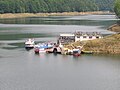
Boat dock near the dam
View of the power plant


Special events
A general overhaul was planned for one of the two bottom outlets from June 24 to July 6, 1974. At noon on July 6, 1974, a leak formed above the river bed and the water jet detached around 10,000 m³ of rock from the slope. On the same day, at around half past seven in the evening, the gate valve, whose power supply lines had been damaged, could be lowered. The amount of water (according to various information) of about 600 m³ / s or 800 m³ / s destroyed the power supply lines of the gate valves, the street in the old river bed in several places, some bridges and houses and two people were officially reported dead. The lake was subsequently emptied and the damage repaired.
Contemporary witnesses report several dead soldiers who worked on Transfogarascher Straße and lived near the dam wall, as well as much greater damage than those reported by the authorities.
See also
- List of the largest dams on earth
- List of dams in the world (Romania)
- List of power plants in Romania
Web links
Individual evidence
- ↑ a b Iulia Vlad: The Vidraru in the press of the 1966s. universulargesean.ro, October 6, 2017, accessed January 1, 2018 (Romanian).
- ↑ The area of today's Vidraru in a general map of Central Europe around 1918
- ↑ Loredana Dascălu: The village under the Vidraru! on July 1, 2013 from "Curierul județului Argeș" accessed online on October 26, 2014 (Romanian)
- ↑ Florina Zainescu: Secrets of the Region on June 20, 2005 at jurnalul.ro, accessed on October 26, 2014 (Romanian)
- ↑ a b The Argeș - Origin of Vidraru at hidroelectrica.ro accessed on October 26, 2014 (Romanian)
- ↑ Video of the opening of the attack on Vidraru accessed on YouTube on October 27, 2014
- ↑ Iulia Șutan: The Vidraru dam will be derived again on August 10, 2010 from "Curierul județului Argeș" accessed online on October 27, 2014 (Romanian)
- ↑ a b c Hidroconstructia SA: Barajul Vidraru și CHE Corbeni. hidroconstructia.com, accessed January 1, 2018 (Romanian).
- ↑ Iulia Șutan: Breaking the dam, almost impossible on August 10, 2010 from "Curierul județului Argeș", accessed online on October 26, 2014 (Romanian)
- ↑ “16.1. Obiective afectabile rupere baraj Vidraru ” on the website of the Romanian Water Management Authority, accessed on October 27, 2014
- ↑ Hidroconstructia SA: Amenajare Ogrezeni. hidroconstructia.com, accessed January 1, 2018 (Romanian).
- ↑ Hidrocentrala Vidraru de pe Arges, un proiect 100% românesc ( Memento of October 31, 2014 in the Internet Archive ) accessed on October 26, 2014 (Romanian)
- ↑ a b Florina Zainescu: Accident at the dam on June 21, 2005 from jurnalul.ro ( memento of October 31, 2014 in the Internet Archive ) accessed on October 30, 2014 (Romanian)