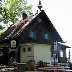
Viktoria-Adelheid refuge
| Viktoria-Adelheid-Schutzhütte ÖTK hut |
||
|---|---|---|
| location | on the Brandstetterkogel ; Lower Austria , Austria ; Valley location: Neustadtl an der Donau | |
| Mountain range | Bohemian mass | |
| Geographical location: | 48 ° 13 '14.4 " N , 14 ° 52' 29.6" E | |
| Altitude | 532 m above sea level A. | |
|
|
||
| owner | Strudengau section of the ÖTK | |
| Built | 1936 | |
| Construction type | Hut; Wood | |
| Usual opening times | all year round, except Tuesday | |
| accommodation | 0 beds, 0 camps | |
| Hut directory | ÖTK | |
The Viktoria-Adelheid-Schutzhütte , today mostly called Brandstetterkogelhütte , is an alpine refuge on a hilltop of the Brandstetterkogel in the village of Schaltberg in the municipality of Neustadtl an der Donau im Strudengau in the district of Amstetten in Lower Austria .
description
The refuge was opened in 1936 on the site of a refuge that was opened in 1926 and has since become too small, at 532 m above sea level. A. built on a hilltop of the Brandstetterkogel and named after Viktoria Adelheid , the wife of the landowner and financier of the building, Carl Eduard Duke of Saxe-Coburg and Gotha . The Strudengau section of the Austrian Tourist Club is the owner of the refuge and maintainer of the Matras dough that ends at the hut . The Danube Heights circular hiking trail from Passau to Ybbs an der Donau leads past the refuge.


