
Vysoká pláň
| Vysoká pláň | ||
|---|---|---|
 Vysoká pláň seen from the Violet Stone |
||
| height | 1497 m nm | |
| location | Poland / Czech Republic border | |
| Mountains | Giant Mountains | |
| Coordinates | 50 ° 46 '43 " N , 15 ° 33' 17" E | |
|
||
| rock | granite | |

The Vysoká pláň (German: Tafelsteinplatte) is a plateau on the western Silesian ridge of the Giant Mountains on the Czech-Polish border.
location
The plateau, whose name Vysoká pláň or Wysokiej Równiny in translation means nothing else than plateau, lies between the peaks of the High Wheel ( Polish Wielki Szyszak , Czech Vysoké Kolo ) in the east and the Violet Stone (Polish Łabski Szczyt , Czech Violík or Labský štít ) in the west and can be reached via the path of Polish-Czech friendship (Kammweg).
In the southwest, the area is bounded by the Labská louka (Polish: Łabska Łąka , German Elbe meadow ), which is about 100 meters lower, and in the south by the Labský důl ( Elbgrund ). On the northern and eastern slopes of Vysoká pláň are the steep rocky slopes of Śnieżne Kotły (Czech: Sněžné jámy , German snow pits ), two extensive glacier cirques .
Valley towns are the Spindleruv Mlyn (Czech: Špindlerův Mlýn, Polish: Szpindlerowy Młyn) located about 7 km to the south-east on the Czech side and Szklarska Poręba ( Schreiberhau ), which is just 6 km to the northwest in Poland.
Nearby peaks
| Ostroga | Koralowa Góra | |
| Violet stone |
.svg)
|
Big balaclava |
| Lysá hora | Gold height | Medvědín |
features
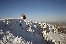
The highest natural point is reached on a rock formation at an altitude of 1497 meters above sea level. This rock group with the wool sack weathering typical of the Giant Mountains is known under the Czech names Krakonošova kazatelna ( giant pulpit ) or Ďáblova kazatelna ( devil's pulpit ); the Polish name is Czarcim Ambona and in German the name Rübezahlkanzel is common.
The granite rocks, which are also the highest rock group in the Giant Mountains, can be climbed via steps and offer a great panorama over the Giant and Jizera Mountains , the Bober-Katzbach Mountains , the Landeshuter Kamm and the Hirschberg Valley . When the weather is clear, you can see as far as Ślęża (German Zobtenberg) in the Sudeten foreland. In addition, there is a little thrill, because below the lookout point, the rock walls plunge over 100 meters vertically into the Great Snow Pit.
Next to it, at an altitude of 1490 m , is the television and radio station R adiowo- T elewizyjny O środek N adawczy Śnieżnymi Kotłami, which is housed in the former Schronisko "Nad Śnieżnymi otłami" ( Snow Pit House ). The origins of this building go back to 1835, when the first youth hostel was founded here at the beginning of tourism in the Giant Mountains through an initiative of Count Schaffgotsch .
gallery

The Hotel Schneegrubenbaude, early 20th century

High wheel, Vysoká pláň and the two snow pits
Snow pits and transmitters on the Vysoká pláň in winter


Individual evidence
- ↑ mapire.eu map from the 19th century