Wallenstedt
|
Wallenstedt
City of Gronau (Leine)
|
||
|---|---|---|
| Coordinates: 52 ° 4 ′ 0 ″ N , 9 ° 47 ′ 57 ″ E | ||
| Height : | 93 m above sea level NHN | |
| Area : | 4.47 km² | |
| Residents : | 299 (Nov. 30, 2016) | |
| Population density : | 67 inhabitants / km² | |
| Incorporation : | March 1, 1974 | |
| Incorporated into: | Rheden | |
| Postal code : | 31028 | |
| Area code : | 05182 | |
|
Location of Wallenstedt in Lower Saxony |
||
|
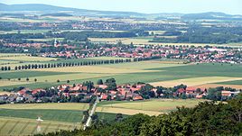
Aerial view of Wallenstedt from the southeast
|
||
Wallenstedt is a district of the city of Gronau (Leine) in the Hildesheim district in Lower Saxony .
geography
Wallenstedt is 1 km northeast of Rheden and 2.5 km south-southeast of Gronau. Heinum is about 2 km to the east on the K 415 district road. At the edge of Wallenstedt, the Heinumer Leine flows into the Rodebach . The glider airfield "An den Sieben Bergen" is located a good 1 km southeast of the town on the northern edge of the Seven Mountains ridge .
history
Wallenstedt was first mentioned in the first quarter of the 11th century under the name Wallenstide . Other names were 1194 Wallenstede and 1206 Wallenstehde . In 1974 Wallenstedt became part of the municipality of Rheden and was incorporated into the city of Gronau in November 2016.
A chapel with the year 1597 in the lintel was demolished in the 1870s. About 1 km south-southeast of the village is an old water mill that used to belong to the Escherde monastery .
The Wallenstedt school became a village community center in 1975. This was later sold by the municipality of Rheden and has served as a restaurant ever since.
politics
City Councilor and Mayor
Since November 1, 2016, Wallenstedt has been represented at the municipal level by the City Council of Gronau (Leine).
coat of arms
The then municipality was awarded the municipal coat of arms on August 16, 1938 by the President of the Province of Hanover . The district administrator from Alfeld presented it on December 20 of the same year.
| Blazon : "On red an old Germanic silver spade helmet withnose irons, which is underlaidbetween the clasps with golden plates decoratedwithribbon motifs." | |
| Justification of the coat of arms: During the early Middle Ages, the "de Wallenstide" family is often documented in Wallenstedt, which showed a helmet as a symbol in the seal. The coat of arms described above is designed based on this model. |
Personalities
Sons and daughters of the place
- Karl Wolter (1879–20th century), director of the Prussian Electricity Corporation
Web links
- Wallenstedt at the Hildesheim cultural portal Kulturium
- Internet presence of the half-timbered house “Brunottescher Hof” from the year 1594
Individual evidence
- ↑ Population of the Leinebergland - Wallenstedt community. In: www.vennekohl.de. November 30, 2016, accessed on September 25, 2017 (PDF; 3.5 kB).
- ↑ a b Wallenstedt. (PDF; 23 MB) In: The art monuments of the Alfeld district, II. The former Gronau district . Self-published by the Provinzialverwaltung, Hanover, T. Schulzes Buchhandlung, 1939, pp. 215–216 , accessed on March 12, 2017 .
- ↑ a b Municipality of Rheden - Wallenstedt. Samtgemeinde Gronau (Leine), accessed on May 7, 2017 .
- ↑ Lower Saxony State Chancellery (Ed.): Law on the unification of the communities of Banteln, Betheln, Brüggen, Despetal, Rheden and the city of Gronau (Leine) as well as on the new formation of the Duingen area and the Leinebergland community, Hildesheim district . Lower Saxony Law and Ordinance Gazette (Nds. GVBl.). No. 22/2015 . Hanover December 15, 2015, p. 399-400 ( digitized [PDF; 278 kB ; accessed on June 29, 2019] pp. 17–18).
- ^ A b Wilhelm Barner : Coat of arms and seal of the Alfeld district . Rebinding. Lax GmbH & Co. KG, Hildesheim 1998 ( digitized version of the text part of the first edition from 1940 [PDF; 10.0 MB ; accessed on June 11, 2019]).


