
Betheln
|
Betheln
City of Gronau (Leine)
|
||
|---|---|---|
 |
||
| Height : | 125 m above sea level NHN | |
| Area : | 17.67 km² | |
| Residents : | 817 (Nov. 30, 2016) | |
| Population density : | 46 inhabitants / km² | |
| Incorporation : | November 1, 2016 | |
| Postal code : | 31028 | |
| Area code : | 05182 | |
Location of Betheln in Lower Saxony |
||
 Betheln in the Hildesheim district
|
||

Betheln is a district of the small town of Gronau (Leine) in the Hildesheim district in Lower Saxony .
geography
Betheln is located east of Elze between the Weserbergland and Harz nature parks . It is located on the western flank of the Hildesheim Forest .
In a northerly direction outside of the place are the remains of an old ring wall , the Beusterburg .
The places Eddinghausen and Haus Escherde belong to Betheln .

Escherde Monastery in Haus Escherde
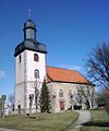
The church in Betheln


history
The place was first mentioned in a document in 1022. His name at the time was Betenem. On May 22nd, 1125, Bishop Berthold registered a branch of the Augustinian Congregation in Marienrode in his church . The church , which until then belonged to St. Mauritius in Moritzberg , was given to the Augustinians. After a major fire caused by lightning, which destroyed the church and many houses in Betheln in 1714, the church was restored in 1733. In 2018 the facade, roof and the eleven windows of the church were renewed.
On March 1, 1974, the communities Eddinghausen and Haus Escherde were incorporated. On November 1, 2016, Betheln was incorporated into Gronau (Leine) with four other parishes.
politics
City Councilor and Mayor
Since November 1, 2016, Betheln has been represented at the municipal level by the City Council of Gronau (Leine).
coat of arms
The municipality was awarded the local coat of arms on October 15, 1938 by the President of the Province of Hanover . The district administrator from Alfeld presented it on December 18 of the same year.
|
|
Blazon : "In green a golden Cheruscan garment from the 1st century AD, so-called fibula with a double-lobed roller cap ." |
| Justification of the coat of arms: Since the historical traditions of the village of Betheln offered no links for the design of the coat of arms, the rich evidence of prehistoric settlement that can be traced back to the Neolithic Age was used. The garment, which was chosen as a coat of arms symbol, was recovered in 1935 in a Cheruscan courtyard on the Schwalenberg in the district of Betheln, which was opened up through an excavation. By unanimous decision, this beautiful piece of jewelery from the past was elevated to the symbol of the community. |
Economy and Infrastructure
- traffic
Betheln is connected to the road network via Bundesstraße 1 , which runs north of the town .
Nature reserve Leineaue under the Rammelsberg
The nature reserve Leineaue under the Rammelsberg lies between Gronau (Leine) and Elze and places a section of the middle course of the Leine with its floodplain and parts of the slopes of the Uthberg and the Großer Rammelsberg in the east under protection. The periodically flooded lowland is characterized by the meandering river course with oxbow lakes and flood channels. The line is often accompanied by remains of alluvial forest . In addition, there are wet meadows and fallow land rich in shrubs . The slopes included in the nature reserve are characterized by forests and shrubbery as well as remnants of poor grassland and orchards .
Personalities
Sons and daughters of the place
- Friedrich von Mejer (1843–1932), Prussian officer, most recently lieutenant general
- Ernst Ohlmer (1847–1927), customs officer , most recently sea customs director in Tsingtau
- Edgar Hennecke (1865–1951), pastor in Betheln
- Hans Hennecke (1897–1977), literary critic and translator
- Walter Hennecke (1897–1984), naval officer, most recently Rear Admiral in the Navy
literature
- Hildesheim and Kalenberger Börde. Nature and landscape in the Hildesheim district. Communications of the Paul Feindt Foundation Volume 5. Hildesheim 2005. ISBN 3-8067-8547-3
- Hildesheimer Land travel guide - paths through Hildesheim and the surrounding area , Gerstenberg Verlag, Hildesheim 2003 and 2006, ISBN 3-8067-8506-6
Web links
Individual evidence
- ↑ Population figures in the Leinebergland - Banteln community. In: www.vennekohl.de. November 30, 2016, accessed on September 18, 2017 (PDF; 3.5 kB).
- ↑ Hildesheimer Allgemeine Zeitung, September 27, 2018, p. 18.
- ^ Federal Statistical Office (ed.): Historical municipality directory for the Federal Republic of Germany. Name, border and key number changes in municipalities, counties and administrative districts from May 27, 1970 to December 31, 1982 . W. Kohlhammer, Stuttgart / Mainz 1983, ISBN 3-17-003263-1 , p. 204 .
- ↑ Lower Saxony State Chancellery (Ed.): Law on the unification of the communities of Banteln, Betheln, Brüggen, Despetal, Rheden and the city of Gronau (Leine) as well as on the new formation of the Duingen area and the Leinebergland community, Hildesheim district . Lower Saxony Law and Ordinance Gazette (Nds. GVBl.). No. 22/2015 . Hanover December 15, 2015, p. 399-400 ( digitized [PDF; 278 kB ; accessed on June 29, 2019] pp. 17–18).
- ^ A b Wilhelm Barner : Coat of arms and seal of the Alfeld district . Rebinding. Lax GmbH & Co. KG, Hildesheim 1998 ( digitized version of the text part of the first edition from 1940 [PDF; 10.0 MB ; accessed on June 10, 2019]).
- ↑ a b Coat of arms of the Betheln community. (PDF; 45 KB) In: Website of the Samtgemeinde Gronau (Leine). Retrieved June 10, 2019 .
.png)
Dumbbells | Barfelde | Betheln | Brüggen | Dötzum | Eddinghausen | Eitzum | Gronau (Leine) | House Escherde | Heinum | Nienstedt | Rheden | Wallenstedt